Storm Highway by Dan Robinson
Weather, photography and the open roadClick for an important message
Storm Highway by Dan RobinsonClick for an important message
The Open Road

"The Open Road" Series

Since 2003, I have spent much of my life on the road, 'living the dream' of photographing storms and covering weather events as a part-time (and occasionally full-time) job. Unlike most people, I love long road trips and almost never get tired of driving. Calling the road my 'second home' would not be too far from the truth. This series documents the sights and scenes along some of my favorite travel routes across the country.

(Recent posts are listed first)

Home | Blog Index | Blog Archives | Christianity & Faith Essays | Storm Chasing Essays

                   Monday, September 6, 2010 - 11:02AM

Second Home: "The Open Road" - Part 5

By DAN ROBINSON
Editor/Photographer
Important Message 30 Years of Storm Chasing & Photography Dan's YouTube Video Channel Dan's Twitter feed Dan's RSS/XML feed


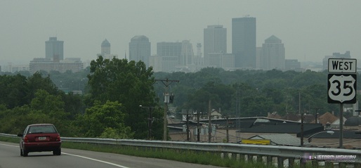
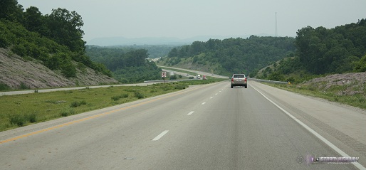
Approaching Dayton, Ohio

This is a resumption of a 3-year-old blog series from back in 2007, a subject that holds an even deeper meaning for me now that these "open roads" have brought me to a new home. Even after moving away from West Virginia, a road trip is still my greatest pasttime. Routes both old and new are always places I look forward to traveling. Thanks to the move to the St. Louis area, I'll have some new routes to add to this series over time. For now, the latest installment covers the one last out-of-state storm chasing route from my West Virginia days.

Part 5: US Route 35 from Scott Depot, WV to Dayton, OH


View Larger Map

Although I-64 was by far my most frequently-used westbound highway for storm chase expeditions, there was one other route that, despite my relative infrequency of using it, deserves a feature in this series. From Charleston, US Route 35 is the best way to reach the upper Midwest and Northern Plains regions, including the cities of Chicago, Indianapolis and Des Moines. It was typically rare for a spring Plains chasing trip to require this route, but all of my lightning-storm chasing trips to Chicago utilized this length of US 35. In addition to the long trips that carried me past Dayton to Chicago and points north, Route 35 was also a common 'local' chasing highway, carrying me to many nighttime lightning outings in southern and central Ohio over the years.

This highway, like many of my longtime routes, has undergone major improvements over the years - namely being upgraded from two to four lanes for all but a short remaining section in West Virginia. Today, Route 35 is interstate-like for most of its length, with only a few isolated places requiring a slowdown from highway speeds.

Some highlights of traveling west on Route 35 from Scott Depot:

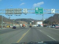
  • Teays Valley/Scott Depot - The recent changes to the US 35 route are most apparent at the highway's southern section in Putnam County, WV. Prior to 2009, starting the journey westward on Route 35 required exiting at the Teays Valley ramp on I-64, then following State Route 34 (pictured at right) to the 35 intersection in Winfield. Traffic was always heavy and slow on this segment, with three traffic lights to get through. Although the true southern terminus of US 35 was at the St. Albans exit near Nitro, the Teays Valley/Rt. 34 connection was a far shorter drive in both time and distance, despite the traffic. If one chose to start at the St. Albans exit, US 35 followed the Kanawha River to Winfield - with a very long speed-restriction zone leading into the town.

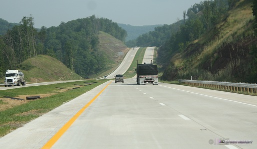
    A major upgrade of US 35 in West Virginia included a completely new alignment of a 4-lane divided highway that interchanged with I-64 at Scott Depot, about 2 miles east of the Teays Valley exit. This interchange now marks the 'true' start of the journey to Dayton and points west and north from Charleston.

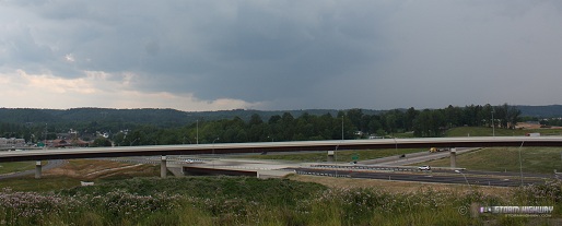
  • Route 34 crossing - The new highway crosses over the 'old' route between Teays Valley and Winfield.
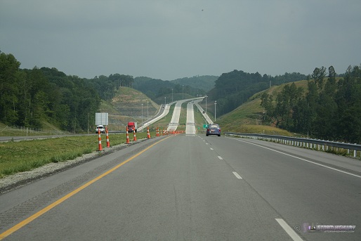
  • Rural Putnam County - The new 4-lane traverses the rolling hills just west of the Kanawha River (and the old alignment) to the Buffalo Bridge.
  • Buffalo Bridge - just north of Frazier's Bottom, the new 4-lane highway ends at the Buffalo Bridge. From here, the route continues on its old alignment along the west side of the Kanawha River to Henderson (Point Pleasant), the only 2-lane section remaining. Construction on the 4-lane upgrade for this segment is still in progress.
     
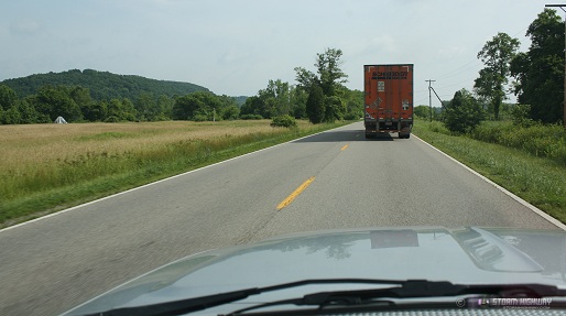
  • 2-lane section - The infamous legacy of the old US 35 unfortunately was its narrow 2-lane section from Winfield to Henderson, on which cars shared the road with heavy truck traffic. Accidents were common on this stretch of the route, ultimately providing the main justification for the 4-lane upgrade.
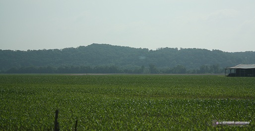
  • Lower Kanawha River valley - Some of the flattest land you'll find in West Virginia lies along the original 2-lane Route 35 north of Pliny, with scenic farmland and open skies very uncharacteristic of the state.
  • Henderson/Point Pleasant - The road widens back to 4 lanes just prior to crossing the Ohio River bridge, next to the Kanawha/Ohio rivers' confluence at Point Pleasant (of Silver Bridge/Mothman fame).
     
  • Southeastern Ohio country - The highway leaves the Ohio River valley quickly, entering a long stretch of rolling hills that include the towns of Jackson and Rio Grande, as well as the original Bob Evans farm.
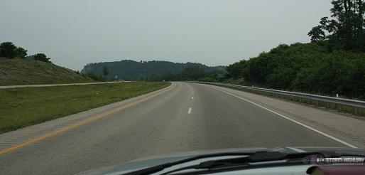
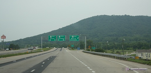
  • Richmond Dale - Another recently realigned and upgraded stretch of the route begins here. Prior to 2005, the old route narrowed to 2 lanes and followed the CSX railroad tracks about 8 miles to just outside Chillicothe. The old route crossed under the railroad twice, with dangerous sharp curves on either side of both underpasses. The new alignment bypasses the entire 2-lane section to the north, providing a continuous 4-lane highway all the way to Chillicothe and on to Dayton.
  • Chillicothe - A good-sized town, one of the largest on the route between Dayton and Charleston and the highway's Scioto River crossing. Chillicothe marks the point at which US 35 leaves the Appalachian foothills and transitions to the flat Midwestern prairie landscape. From here, Columbus is a short distance to the north, Portsmouth is due south.
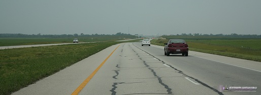
  • Ohio prairies - Much of Ohio is flat, particularly in its western and northern sections. From Chillicothe westward, terrain along US 35 is indistiguishable from nearby Illinois and Indiana - with cornfields and open skies typical of the American Midwest.
  • Washington Court House - another good-sized town with another recently-upgraded section that previously required traversing two-lane segments with traffic lights. Everything now is 4-lane highway like the rest of the route in Ohio.
     
  • Interstate 71 - I-71 is the only interstate highway encountered on the route between I-64 and the Dayton metro area. I-71 connects Cincinnati and Columbus.
     
  • Xenia - Hallowed ground for storm chasers, Xenia was the site of the infamous F5 tornado during the April 3-4, 1974 Super Outbreak. On the west side of Xenia, the highway's limited access status ends for roughly 3 miles, with several traffic lights to get through before resuming non-stop travel.
     
  • Dayton metro - US 35 resumes its interstate-grade quality through the Dayton metro area.
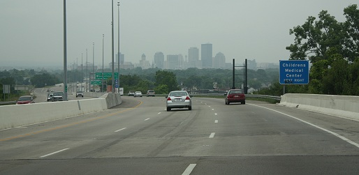
  • I-75 interchange - The typical trip on US 35 comes to an end at the I-75 interchange in downtown Dayton. From here, a turn north on I-75 to westbound I-70 is the path to continue the trip to Indianapolis, Chicago and points beyond in the upper Midwest and northern Plains.

NEXT ROAD: Stay tuned!

"Open Road" Blog Series:
Part 1 - I-64 from West Virginia to Missouri
Part 2 - I-44 from Missouri to Oklahoma
Part 3 - I-79 from West Virginia to Pennsylvania
Part 4 - I-77, I-74, Route 52 and I-40 from Charleston to Raleigh
Part 5 - Route 35 from Teays Valley to Dayton
Part 6 - I-70 from St. Louis to Kansas City (still to come)
Part 7 - I-55 from St. Louis to Chicago (still to come)
Part 8 - I-55 from St. Louis to Sikeston (still to come)

Home | Blog Index | Blog Archives | Christianity & Faith Essays | Storm Chasing Essays

                   Thursday, November 8, 2007 - 11:02PM

Second Home: "The Open Road" - Part 4

By DAN ROBINSON
Editor/Photographer
Important Message 30 Years of Storm Chasing & Photography Dan's YouTube Video Channel Dan's Twitter feed Dan's RSS/XML feed


Downtown Raleigh, NC

North Carolina has always been a part of our family. Various relatives scattered around the Tar Heel state meant that a trip each summer to visit everyone was a Robinson tradition. I had great aunts in High Point, great-grandparents in Kinston, an aunt, uncle and cousins in Raleigh, and an aunt and uncle in Murfreesboro (I have just as many North Carolina roots as I do West Virginia). The usual Robinson NC trip consisted of a 2 to 3 day stop in each of those locations, followed by a trip to the coast to go to the beach, usually at Atlantic Beach/Morehead City. Occasionally, the trip would include a drive across the Chesapeake Bay Bridge-Tunnel up to the eastern shore town of Parksley, Virginia to see another great-grandmother. In retrospect, during those trips we never envisioned the significance that Raleigh would come to have for us in our futures. My brother and sister both decided to attend North Carolina State University after they graduated from high school, and both met their future (NC native) spouses there, further entrenching our family ties to Raleigh. In the midst of all this, my late grandmother purchased my brother-in-law's former house, which served as her 'second home' as well as our family's 'base' in Raleigh for many years. And even I myself have briefly entertained the possibility of moving to Raleigh - a prospect that even now, isn't entirely out of the question for the distant future.

My first trips to North Carolina were as an infant - and they are still continuing today. From those early days of my childhood until now, the familiar route from West Virginia to the North Carolina Piedmont has remained the same - but many things have changed along this route in those 30 years.

Part 4: I-77, I-74, Route 52 and I-40 from Charleston to Raleigh


View Larger Map

The route from Charleston to Raleigh includes traveling on four highways - Interstate 77 from Charleston to Mount Airy (including the WV Turnpike), Interstate 74 and Route 52 (future Interstate 74) from Mount Airy to Winston-Salem, and Interstate 40 from Winston-Salem to Raleigh. While today the entire route consists of four-lane-minimum limited-access highway, it hasn't always been that way. During the early years of my childhood, the West Virginia Turnpike was originally a two-lane road for part of its length, and the Mount Airy connection to the Route 52 highway required a few two-lane roads and intercity streets (with traffic lights) for many years. I-40 was a paltry four lanes for much of its length in those early years, compared to its mostly six, eight and ten-lane sections today. Today, the entire 318-mile journey (without stops) takes roughly five hours.

Some highlights of traveling south on I-77 from Charleston:

  • Rising mountains - East of Charleston, the sharp rise in ridgetops indicates the route's plunging deep into the heart of the Appalachian mountains.
     
  • Belle DuPont plant - Across the river from Marmet lies the huge DuPont chemical plant, intensely lit up with thousands of lights at night.
     
  • Cabin Creek - Here, the highway sharply curves away from the Kanawha River, permanently leaving the valley to start the mountainous climb toward Beckley and the summit at Flat Top. The speed limit also drops from 70mph to 60 here as the West Virginia Turnpike officially begins. The turnpike's first toll booth is just beyond the curve.
     
  • Cabin Creek Valley - The 60mph speed limit is well-justified through this section of very sharp curves bounded by steep mountains on either side. The jersey barriers on either side bear scars and missing chunks of concrete from the frequent accidents.
  • Memorial Tunnel and cut/fill - A few miles past the Sharon exit, the highway leaves the Cabin Creek valley and climbs over a summit into the Paint Creek valley. At the crest of the hill, a massive cut marks the location of the old Memorial Tunnel, which is still visible to the west of the road. Memorial Tunnel, a two-lane bore, was in service during the Turnpike's pre-interstate years. It was abandoned after the four-lane highway was finished in 1987. Immediately after the cut is an equally massive fill across the valley, previously spanned by the Bender Bridge. The bridge was demolished when the interstate was completed, leaving the south portal of Memorial Tunnel to dead-end out of the side of the mountain. Today a narrow access road leads up to the tunnel, which is now used for Homeland Security traning excercises.
     
  • Paint Creek Valley - The mountains are high, steep and scenic through this almost gorge-like valley, in which the interstate meanders perilously through. The abandoned right-of-way from the Paint Creek branch of the C&O railway is visible snaking along the valley along the interstate, with a few old bridges still in place. The tortuosity of the highway here contributes to another section with a high accident rate.
  • Mahan - The forgotten coal mining town of Mahan lies isolated in the valley, nearly invisible to passing drivers if not for its blessing of having an exit from a busy four-lane highway nearby.
     
  • Mossy - The highway is gaining some significant elevation by the time the road reaches Mossy. A mile or two north of the Mossy exit boasts some spectacular mountain vistas to the east. South of Mossy, the interstate enters a less-curvy plateau-like region, where the speed limit accordingly increases back to 70mph.
  • Pax - The second toll booth on the turnpike demands another $1.25 from your car's coin holder and signals that you're approaching the small town of Pax. The old Virginian Railway line (now Norfolk Southern) merges in close to the highway here, roughly following alongside of it for the next five miles or so.
     
  • Bradley - A couple of miles before you reach the Route 19 interchange at Bradley, the highway makes a major climb upgrade to 2500 feet and the Beckley area plateau. During the winter, this stretch of road is known for being a common rain/snow changeover point as the elevation increases.
     
  • Tamarack - Tamarack is the round, spiked red-roofed craft shop/museum at the Beckley rest area/travel plaza. The goods here are expensive, but the food is worth stopping in for.
     
  • Beckley - A seemingly isolated mountain urban center, Beckley is surprisingly large and bustling for a town located where it is. They've even got an Outback Steakhouse and a couple of Starbucks now.
     
  • I-77/I-64 split - I-64 breaks off and heads east toward Richmond and Virginia Beach.
     
  • Flat Top - Just after the third and final toll both of the turnpike, the highway crests the summit of Flat Top Mountain at over 3200 feet. Just past the summit, a sweeping view of distant mountains is visible straight ahead.
     
  • Princeton - The last good-sized town on I-77 before the state line, Princeton is located right off of the highway and has experienced growth in recent years.
     
  • Ingleside - A high steel bridge carries the former Virginian railway over the interstate here as the road descends into the East River valley.
  • East River Mountain - The first of two tunnels on I-77 carries the road across the state line into Virginia through East River Mountain, a classic Appalachian ridge that stretches as far as the eye can see from right to left. Although the Bluefield exit is located here, the actual town is some distance west of the highway.
     
  • Bland - The Bastian and Bland exits lie in the valleys between the long, high ridges. A gas station at Bland competes with Wytheville's low gas prices, and its lesser traffic flow has made it my preferred stopping point.
  • Big Walker Mountain - The second and final tunnel on the southbound I-77 trip.
  • Wytheville - Wytheville has been a common stopping point on our North Carolina trips, mainly due to the gas prices usually being 20 to 30 cents cheaper than most other places along the way. I-77 interchanges with I-81 here. The Log Cabin restaurant downtown is a good dinner stop.
     
  • New River Valley - The highway crosses the New River at Poplar Camp on a high, newly refurbished bridge. The 'Shot Tower' and park is visible off to the east of the road.
     
  • Fancy Gap grade - I-77 leaves the Appalachians just south of the Fancy Gap exit, descending 1800 feet down the face of the eastern edge of the mountains on a steep grade. Three runaway truck ramps testify to the length and steepness of the descent. The views to the east here are spectacular, with the rolling hills of the Virginia and North Carolina Piedmont extending to the horizon. In the distance, Pilot Mountain rises from the landscape. On a clear day, even the skyline of Winston-Salem (50 miles away) is briefly visible to the left of Pilot Mountain. Unfortunately there are no places to stop to take in this view, so enjoy it during the one or two minutes that it is visible. At the base of this long grade is the North Carolina state line.
  • Mount Airy - The route to Raleigh necessitates leaving I-77 here on the new I-74 connection to Route 52 at Mount Airy. Mount Airy is the hometown of Andy Griffith and the supposed inspiration for the classic TV show bearing his name.
     
  • Pilot Mountain - One of the most prominent landmarks of the entire trip is the unmistakeable Pilot Mountain, an isolated peak with a distinctive rock dome rising to 2500 feet beside Route 52.
  • Winston-Salem - An impressive skyline highlights this busy metro area, the first major city encountered on the trip. At downtown, the turn eastward on Business I-40 toward Raleigh is made. We've timed the Business 40 route versus continuing to the main I-40 interchange south of town, and the former route is faster by a few minutes.
  • Greensboro/High Point - Once Business I-40 joins the main I-40 near Kernersville, the highway expands to 10 lanes. From this point eastward, a fairly continuous pattern of dense urban sprawl, wide highways, businesses, hotels and factory outlet stores fill up the space on either side of I-40. The growth of this region is more than apparent, with new highways and interchanges going in in multiple spots. The Koury convention center is the tallest building along the highway between Winston-Salem and Raleigh.
  • Durham - Raleigh's 'sister city' is not visible from I-40, but its suburbs stretch south across the highway.
     
  • Raleigh metro - The trip for us ends in Raleigh, with the skyline peeking briefly above the trees along I-40.
     
Next road: Route 35 from Teays Valley to Dayton

Home | Blog Index | Blog Archives | Christianity & Faith Essays | Storm Chasing Essays

                   Thursday, September 27, 2007 - 5:09PM

Second Home: "The Open Road" - Part 3

By DAN ROBINSON
Editor/Photographer
Important Message 30 Years of Storm Chasing & Photography Dan's YouTube Video Channel Dan's Twitter feed Dan's RSS/XML feed


Classic Interstate 79 scenery near Frametown, WV

Of all the roads in the country, no highway is more familiar to our family than Interstate 79. Counting trips by me, my parents, brother and sister collectively, this stretch of road has been traveled by us literally hundreds of times during the last 25 years. I was 7 years old when I first made the trip, as my family and I moved from Charleston, West Virginia to Washington, Pennsylvania in 1982. With my grandparents still in Charleston, each year saw us making at least 4 round trips down I-79. Even as a kid, I had all of its exits and landmarks memorized - even to the point of compiling a crude 'traveler's guide' for the route. Every childhood memory of mine from Christmases, Thanksgivings and summer vacations past involve this highway, making it so familiar that I never feel like I'm traveling as I'm driving on it. Today, Interstate 79 still plays an integral role in our family's transportation routes, and probably will for decades to come.

Part 3: I-79 from West Virginia to Pennsylvania


View Larger Map

Interstate 79 in West Virginia follows the western side of the Appalachian Mountains northeastward from Charleston, staying mostly in the rugged and scenic foothills to the west of the higher terrain. The topography along the route means there are very few flat and straight sections, however the mostly mild curves are still comfortably negotiable at the 70mph speed limit. While the highway travels in a general north-northeasterly direction, the winding route occasionally turns east and even southeast in spots. The road meanders through a landscape comprised of tree-covered mountains and hills, fully green in the summer, brown in the winter and spectacular with colors in the fall. While much of the route is in remote rural country, the I-79 traveler is never far from the neccessities of the road - with food and gas stations located near most of the exits.

Some highlights of traveling north on I-79 from Charleston:

  • Airport approach light superstructure - We used to call this unusual structure the 'airplane bridge': a series of guyed towers joined by a continuous truss at the top. The structure, visible from I-79 at Mink Shoals, carries the approach lights across a deep valley at the north end of the main runway at Yeager Airport. Since Charleston's airport is built on top of a mountain, with steep dropoffs at the ends of the runways - the tower structure is the only way to allow the approach lights to be installed on a level grade with the main runway. The structure runs through the heart of Charleston's Coonskin Park.
     
  • Elkview - The small community has seen a recent explosion of development at the I-79 interchange, with hotels, restaurants and grocery stores.
     
  • Elk River - The Elk River loosely parallels I-79 from Charleston to Flatwoods, crossing under the highway at Frametown and Sutton. The river is a short drive east from the exits at Elkview and Clendenin.
     
  • Amma - Sandy Brae golf course is part of a nice scenic view looking eastward.


  • Wallback - Your sense of direction will be challenged approaching Wallback, as the highway turns east and then southeastward before the exit, then more than 90 degrees back to the northeast past the exit. In November, cars and trucks will be parked off of the highway as hunters take to the woods for deer season.


  • Frametown/Route 19 - The junction with Route 19 takes place just north of here, near the summit of one of the higher grades of the highway. Route 19 has become a major north-south artery itself, after being expanded to four lanes all the way to Beckley. This has made it a preferred connection for travelers coming north on I-77 from the southeastern US states. As a result, the traffic flow on I-79 will often increase abruptly at the Route 19 interchange northward.
     
  • Sutton - The final crossing of the Elk River takes place here as the highway takes a more permanent turn toward the north. An impressive concrete dam holding back Sutton Lake is located a few miles east of the exit, but is not visible from the interstate itself.
     
  • Flatwoods - Located in a bowl-like valley, Flatwoods is another area that has seen development in recent years with the addition of a factory outlet mall.
     
  • Burnsville - The town of Burnsville lies deep in the Oil Creek/Salt Lick Creek valley. This exit has the distinction of being exit #79, at milepost 79, on Interstate 79, a fact the "79er" family restaurant takes advantage of. Another major grade is located past the Burnsville exit, carrying the highway to a scenic series of ridgetops.


  • Weston - Route 33 (Corridor H), another recently four-lane-expanded highway to the east, interchanges here. Weston marks the halfway point between Charleston and Washington, PA.
     
  • Lost Creek - An abandoned railway grade follows the highway here, crossing an old wooden trestle at one point. The rail line was active as recently as the early 90s, serving a now-shut down coal mine near Jane Lew.
     
  • Clarksburg - Next to Charleston, Clarksburg/Bridgeport is the largest urban area in West Virginia served by I-79. A large selection of restaurants make it a common stop for lunch or dinner on the way. Past the main Clarksburg exit, look for the B&O railroad tunnel to the west of the highway - for a split second, you can see all the way through it.
     
  • Shinnston - A new FBI facility is located at the brand-new Jerry Dove Drive interchange here.
     
  • Tygart River - The highway crosses the Tygart on a high bridge here. Look east for the tall railroad bridge across the river.
     
  • Fairmont - Another respectable urban center that has been seeing quite a bit of construction on I-79, including a new interchange and arch bridge across the highway.


  • Monongahela River - Just past the interchange with I-68, the interstate crosses the highest and longest bridge of the route over the Monongahela River Valley.
     
  • Morgantown - While descending another long grade before the first of three Morgantown exits, the distinctive dome of the West Virginia University's basketball coliseum is visible in the distance.


  • Osage - On the right of the highway just past the Star City exit, an abandoned coal mine entrance is visible. At one time, electrified tracks were installed here, but were recently removed.
     
  • Mount Morris/Pennsylvania state line - One of the few state lines where the change in highway maintenance practices is evident, with West Virginia surprisingly having the smoother roads of the two.


  • Kirby 'railroad pipes' - Railroad tracks pass under the roadways here via huge corrugated steel pipes.
     
  • Southwestern Pennsylvania terrain - While the hills seem to become only slightly less rugged here, Pennsylvania's hills have much more open fields and meadows than trees compared to West Virginia. The result is some nice scenic views in spots whenever the highway rises in elevation.


  • Waynesburg - The seat of Greene County, with an airport beacon located on top of a hill rather than on top of the control tower.
     
  • Ruff Creek mine subsidence - Underground longwall coal mining is common in this part of the state, where large machines remove the coal seams and allow the rock to collapse behind it. The result is corridors of surface subsidence that visibly affect the roadway, the most dramatic of which can be seen after the Ruff Creek exit. On this straight stretch, several dips in the road from the collapse of underground mines are evident.


  • Laboratory/I-70 interchange - I-79 'multiplexes' (shares) a stretch of highway with I-70 through part of Washington, starting with an interchange just past the town of Laboratory. Northbound I-79 traffic must negotiate one of the sharpest curves on the interstate system here - nicknamed 'The Dangerous Curve' by us as kids due to the numerous accidents that happen here. The huge concrete wall on the outside of the curve bears the scars of frequent vehicles crashing and scraping along it.


  • Washington - The Beau Street exit is the the northern terminus of the typical Robinson family trip on I-79.
     
Next road: I-77 and I-40 from Charleston to Raleigh

Home | Blog Index | Blog Archives | Christianity & Faith Essays | Storm Chasing Essays

                   Sunday, September 23, 2007 - 7:04PM

Second Home: "The Open Road" - Part 2

By DAN ROBINSON
Editor/Photographer
Important Message 30 Years of Storm Chasing & Photography Dan's YouTube Video Channel Dan's Twitter feed Dan's RSS/XML feed

St. Louis has grown on me ever since I first passed through late one evening in May of 2001, on my way to my first Great Plains storm chase expedition. In a way, St. Louis was (and is) a symbol of my new-found freedom in the open road. It was the first new major city I had visited alone, and marked (up to that point) the longest single drive I had traveled solo. From Charleston, St. Louis is a little more than halfway to the Great Plains region, and is a landmark milestone in the trip westward. When I see the Arch, I know the open skies, big storms and new, unexplored territory of the Plains are just a few more hours away.

Part 2: I-44 from Missouri to Oklahoma


View Larger Map

Interstate 44 has also made it high on my list of favorite highways. When the severe weather targets set up in Oklahoma and Texas, I-44 is the 'home stretch' of the trip - with St. Louis well past the halfway mark to the first Great Plains destination city of Tulsa, 395 miles and little less than 6 hours' drive away. Tulsa has become a common 'launching point' for many of my storm chase expeditions since I started, thanks in part to the hospitality of veteran observer Dave Crowley and the members and good friends of our original observing group who also lived in the area. Although Kansas and the I-70 route have brought many great tornado intercepts, I'm always hoping that the storms will set up south of the Kansas border - making I-44 the route inbound. Once in Tulsa, most targets in Oklahoma, northern Texas and southern Kansas are within a 4 to 7 hour drive, enough time to leave in the morning to make a late afternoon storm initiation.

Some highlights of traveling west on I-44 from St. Louis:

  • Downtown St. Louis - As soon as I-64 crosses the Mississippi into downtown St. Louis, the first exit ramp begins the jump over to I-44 along a brief section of I-55, passing next to Busch Stadium in the process.
     
  • Maplewood, MO - A strange landmark in the form of two mysterious towering, cylindrical trusses is located in this St. Louis suburb. From the info I can gather, these are abandoned natural gas storage tanks called 'gasometers' with telescoping expandability.
     
  • Ozark mountain terrain - Traveling westward, one can see the topography on I-44 west of the Mississippi is in stark contrast to the flat prairie-like land along I-64 in southern Illinois. I-44 plunges into Ozark country for much of its journey across southern Missouri, with rolling hills punctuated by a few deep valleys and high ridges. The first major hill is enountered west of the I-270 beltline interchange. While not as rugged as the Appalachians, a few spots in the Ozarks are reminiscent of West Virginia scenes.


  • Allenton - The roller coasters of the Six Flags amusement park, located just north of the highway, are visible here.


  • Route 66 - The entire length of I-44 between St. Louis and Tulsa follows the alignment of the historic Route 66 highway. In some places, the original Route 66 parallels the interstate as a frontage road, in other spots the interstate replaces it altogether.
     
  • Jerome/Newburg - The highway descends into one of the deepest valleys on this section of the route. The eastern grade of the descent was recently re-routed to form a much straighter alignment.
     
  • Tourist traps - Numerous repeating billboards relentlessly advertise the area's popular caves, an outdoor wild animal exhibition, and Branson's shows and attractions.
     
  • Springfield - Second to St. Louis, Springfield is the largest city served by I-44 in southern Missouri. Billboards for nearby Branson (a Vegas-like tourist destination) clutter the highway.
     
  • Karst topography - As I-44 exits the Ozarks, the rolling hills reveal the Karst topography common from near Springfield to around the Oklahoma state line. Every so often, large light-colored boulders and rocks jut from the grassy fields and embankments along the highway.
     
  • Joplin - The last major city on I-44 before the Oklahoma state line. The Joplin-Springfield area is the common overnight stopover point for many of my Plains storm chasing trips, with the usual arrival time there between 1 and 3 AM. Many times my overnight stays (if I'm by myself) are in my car, at either one of the two rest areas or any secluded, quiet place I can find. I don't do this as much as I used to, but 'car lodging' was and is symbolic of the new freedom I was enjoying on the road - the cost savings from hotel stays is what financially enabled me to make many of those first trips to the Plains.
     
  • Baxter Springs/Galena, KS - The site of the last exit on I-44 in Missouri before the Oklahoma state line. The exit is labeled for Kansas towns, because they are closer than the nearest Missouri or Oklahoma town. The 'triple-point' of Kansas, Missouri and Oklahoma is located within a few hundred yards of here. If you're so inclined, you can take the exit and drive a couple of minutes to the point (on a dirt road) where all three states meet. The Baxter Springs exit is also the last chance to stop before entering the tolled Will Rogers Turnpike section of I-44.
     
  • Oklahoma state line - When you first enter Oklahoma, the terrain doesn't immediately announce that you're entering the Great Plains region. However, that gradually changes during the next 20 miles as you move westward.


  • Northeastern Oklahoma country - Exits are few and far between here - come to think of it, paved roads are scarce too - with the occasional dirt road crossing over the highway on concrete overpasses. The land flattens out dramatically by Miami, though the gently rolling hills are not quite as flat as you would expect. In fact, a newcomer to these areas will discover that large portions of the Plains states are not flat at all, particularly the eastern ends of Kansas, Texas and Oklahoma.
     
  • Vinita - The rest area near Vinita boasts the claim to the largest McDonald's restaurant in the world, built across all four lanes of the highway.


  • Tulsa - The trip to the Plains is complete! From here it's westward on any number of potential routes to wherever the severe weather patterns set up.

Next road: I-79 from Charleston to Washington

Home | Blog Index | Blog Archives | Christianity & Faith Essays | Storm Chasing Essays

                   Tuesday, September 18, 2007 - 1:26PM

Second Home: "The Open Road" - Part 1

By DAN ROBINSON
Editor/Photographer
Important Message 30 Years of Storm Chasing & Photography Dan's YouTube Video Channel Dan's Twitter feed Dan's RSS/XML feed

During the past seven years, I have spent much of my life on the road, 'living the dream' of photographing storms and covering weather events as a part-time (and occasionally full-time) job. Unlike most people, I love long road trips and almost never get tired of driving. Calling the road my 'second home' would not be too far from the truth. My storm chase expeditions across the country have opened my eyes to the world outside of my home state, so much so that for the first time, the prospect of moving away became more appealing. The fact that I've started considering living in new places is largely a result of storm chasing and the 'open road' making me more comfortable with new horizons.

Part 1: I-64 from West Virginia to Missouri


View Larger Map

By far, this section of I-64 has become my favorite travel highway. Since I began my photography chases to the Great Plains in May of 2001, I have made no less than 19 round trips (38 trips each way) on Interstate 64 between Charleston, West Virginia and St. Louis, Missouri. Nearly every storm chasing trip will take me either west on I-70 (to Kansas and Nebraska) or southwest on I-44 (to Oklahoma and Texas), making I-64 to St. Louis my 'gateway' to the Plains. The 506-mile leg to St. Louis takes a little over 7 and a half hours, crossing five states and a time zone boundary in the process. I look forward to the trip out west as much as I do the destination, and despite the long distance it is never tiring or boring.

Some highlights of traveling west on I-64 from Charleston:

  • Teays Valley, WV - This stretch of I-64 runs through some of the flattest topography in the state. Here I usually set my clocks to Central Time, since that's where I will be at the end of the day.
     
  • Cattlettsburg, KY - The sight of the oil refinery on the Big Sandy marks the first state line crossing of the trip. Leaving West Virginia and entering Kentucky brings on the feeling like the journey is finally 'under way'.


  • Grayson, KY crosses - Three wooden crosses on an isolated hill near the interstate have stood the test of time, despite much of the hill being excavated away around them.


  • Morehead, KY - A common place to stop for a cold drink, namely the ginger-ale-like "Ale-81".
     
  • Owingsville, KY - Here I-64 crosses the western boundary of the Appalachian mountain topography. Between Owingsville and Mt. Sterling, the mountains abruptly end as the road breaks out into the classic rolling hills and open fields of Kentucky Bluegrass country.
     
  • Lexington - Lexington lies in the heart of Bluegrass country, with rolling hills and open skies. Endless brown, black or white wooden horse fences stretch across vast, green fields.
     
  • Louisville - The first major city encountered on the trip, with the highway squeezing close in between big Ohio River road and rail bridges to the north and the downtown skyline to the south.


  • New Albany, IN - The towering double-deck bridge over the Ohio marks the second state line crossing of the trip.


  • Indiana hills and forests - I-64 enters a hilly, forested area that covers much of southern Indiana, parts of which are within the boundaries of Hoosier National Forest. I-64 crosses the Eastern/Central Time Zone boundary here. Near the end of this region lie the towns of Jasper and Santa Claus.
     
  • Evansville - By the time I-64 reaches the Evansville area, the Southern Indiana hills have leveled off into flat, open fields. The interchange at Highway 41 is the designated first stop for fuel of the trip. Gas prices here tend to be the lowest of anywhere I have traveled, and the pumps are usually very busy. In the springtime, bright, photogenic yellow flowers often cover many of the fields here.


  • Griffin, IN - This small town on the Wabash River floodplain was in the path of the infamous Tri-State tornado of 1925. Past Griffin, the sightings of oil and natural gas pumping jacks become more numerous, many of which have open flames burning from small stacks. Some of the pumping jacks near the Wabash river are elevated on platforms to protect against the frequent floods.
     
  • Wabash River - The Wabash River bridge marks the third state line crossing of the trip. An old railroad bridge is to the north, with one of the spans collapsed into the water from a previous flood. If you stop at the rest area on the Illinois side, listen for the chugging of the old gas pump jack next to the parking lot.
     
  • Southern Illinois country - Flat and sometimes swampy ground is the norm for some distance before and after Burnt Prairie. Watch out for the legions of large insects hitting your windshield at dusk through this stretch! Some of the land is so flat and treeless here that it is almost indistinguishable from the Great Plains.
     
  • Mount Vernon, IL - A brief merger with I-57 takes place here.
     
  • Mascoutah, IL - Mid-America airport and Scott Air Force Base, both visible to the south, are signs that St. Louis is close. Plains-like flatness abounds here also.
     
  • Fairview Heights, IL - Just past this exit, the Interstate descends the bluffs down onto the Mississippi floodplain, at which point the Gateway Arch and downtown St. Louis skyline first become visible in the distance.
     
  • Mississippi River Bridge - The 'Grand Entrance' to St. Louis, with a spectacular view of the Arch to the right.

Next road: I-44 from St. Louis to Tulsa

30 Years of Storm Chasing & Photography
Important Message
Dan's YouTube Video Channel
Dan's Twitter feed
Dan's RSS/XML feed

GO: Home | Storm Expeditions | Photography | Extreme Weather Library | Stock Footage | Blog

Featured Weather Library Article:

How lightning works
Does it go up or down? A detailed description of lightning from start to finish.
More Library Articles

All content © Dan Robinson. All usage requires a paid license - please contact Dan for inquiries.

Web Site Design and Internet Marketing by CIS Internet