DAY 1: Charleston to Louisville
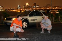
Louisville - Digital photo by Matt Robinson
EXPEDITION VIDEO: WV/KY storms, Windows Media, 3MB
Day 1 was eventful and long, and I'm exhausted - so this entry's eloquence is going to suffer. After last-minute scrambling to get final obligations taken care of in the morning, this trip is finally 'officially' under way.
To make things interesting right off the bat, the atmosphere threw us a little bit of a curveball today. Matt arrived in Charleston, and we were heading west by 6PM EDT. Not content to let us make a hasty exit, storms fired in West Virginia and Kentucky, and were impressive enough for us to stop and grab a few shots in Charleston and Huntington:
Video captures - click to enlarge
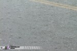  
Small hail and lightning were the only attractions today, nothing compared to what we are expecting to see out west. Nonetheless, we spent a couple of hours filming the show. We stopped by the WOWK-TV (Channel 13) studios in Huntington to share the catches - which you may have seen on their 11PM Charleston/Huntington broadcast.
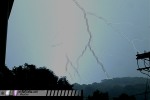
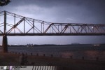
After these unplanned diversions, we continued west, stopping twice to check out the Lexington and Louisville metro areas after dark. Matt will be posting more of his skyline shots on raleighskyline.com later. BELOW: The Storm Highway Freestyle in urban Kentucky scenes - Lexington (left) and Louisville (center and right):
Digital photos by Matt Robinson - click to enlarge
  
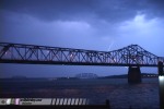
Weakening storms rolled through the Louisville metro late, giving us a few more photo opportunities. We tried for some Ohio River bridge/lightning shots until the rain moved in.
Digital photo by Matt Robinson - click to enlarge
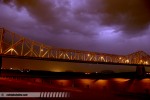
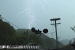
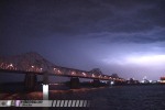
BELOW: Matt sets up and shoots lightning over a bridge in Louisville:
Video captures - click to enlarge
After a somewhat difficult search for a reasonable hotel with WIFI, we're currently staying along I-65 in southern Indiana for the night - with Indianapolis and Chicago on the timetable for Saturday.
So what about the tornadoes? Well, we just missed a string of active days in Texas, and the next few days in the Plains look to be very quiet severe weather-wise. So, we're taking this time to relax and tour some midwestern cities while we wait for the atmosphere to recover out west. The long-range forecast models are showing that severe weather will return to Tornado Alley by Thursday or so of next week, so we are expecting some good storm photography days up ahead.
Thunder and lightning are *still* ongoing outside the hotel as I type this, but we're too tired to give it any attention. Signing off, until tomorrow...
GO: Home | Storm Expeditions | Photography | Extreme Weather Library | Stock Footage | Blog
Featured Weather Library Article:
|