 Severe storms in southern IL: April 24, 2010 Severe storms in southern IL: April 24, 2010
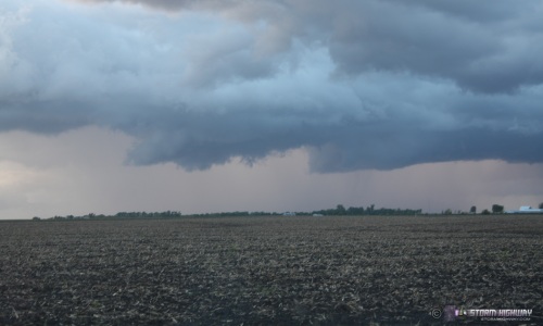
ABOVE: A small storm briefly gets organized near Trenton, IL on April 24, 2010.
HD EXPEDITION VIDEO: Lightning near Irvington, IL: Watch Video
Click any thumbnail on this page to view a larger version.
TRENTON, IL - Today was the first SPC High Risk day of the year, with the bulk of the extreme tornado threat down in the deep south. However, parameters supported tornadic storms well to the north, and the SPC included much of southern and central Illinois in a Moderate Risk. A surface low was forecast to move eastward into southern Illinois by evening, with strong winds at all levels providing ample directional shear. Since the southern areas in the High Risk would be under the gun very early in the day, and since numerous storms were in progress between St. Louis and the southern target by early morning, I decided to stay close to home and cover the threat in Illinois. Due to lacking instability, I did not expect to see much, but with the extreme wind profiles and low center close by, I knew I could not ignore any storm that went up here. The day ended up as mainly a 'scenic storm' photography day, with the closest to anything looking supercellular occuring after I arrived home in the evening.
I left New Baden at 11:30AM and headed eastward to intercept a storm moving up west of Paducah, Kentucky. The thinking was to intercept a broken line of cells as they moved up through the Paducah/Evansville region, where instability was slightly better. I made it all the way to the Ohio river crossing near Shawneeville, IL before finally getting a visual on the storm's inflow region. The storm showed no signs of organization, so I decided to break off of this region and head back west to where small cells were developing closer to the low center.
I was too far away to catch the tornadic storm moving through St. Louis, and probably would not have opted to intercept it anyway, due to the traffic and visibility around the metro area. Storm chasing in a large city is almost never a good idea. The ironic thing about being a storm chaser is that you are most likely not going to be close to home during a major severe weather event, unless the parameters strongly point to a storm right at home - and that is very rare. Typically the setup will take you some distance away from home, and if an odd storm happens to go through your town, you are more than likely not going to be there for it. I've come to accept that fact - if something big ever happens in my home area on a major storm chase day (in this case downtown St. Louis or at my apartment), I'm probably going to miss it! As a storm chaser, you have to go to where the data tells you that the better parameters are - a continual confinement to a single metro area, in spite of the data pointing elsewhere, may allow you to catch the odd event or two - but will cause you to miss many more faraway storms and tornadoes than you'll miss at home.
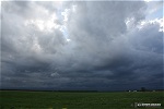
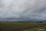
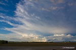
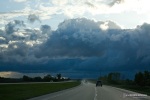
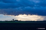
So at this point, I just decided to get in front of the cells now developing in a line south of St. Louis. The storms would cross I-64 at and west of Mount Vernon, so I made it to Irvington (south of Centralia) and waited. At one point, WxWorx showed a 115mph shear marker on the storm just to my southwest, but I saw no corresponding structure. These two images show the storms - severe warned at this point for wind - about 35 minutes and 20 minutes before arrival, respectively:
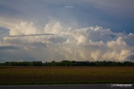
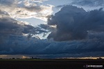
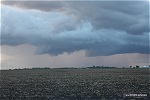
The lightning was infrequent (see video above) but seemed to slowly fizzle as the storms approached. I saw no lightning flashes as the activity passed over. As the precip hit, I headed back to the interstate, hitting an area of intense winds probably around the 60mph range just north of the interchange. I was out of the rain completely at Okawville (that's pronounced 'Oak-aville' if you're wondering) and had a nice view of the back side of the storms to the north:
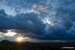
At this point, a tiny cell south of St. Louis had just started producing lightning strikes. Again, though it appeared weak on radar, it was in such a potent environment that I didn't think I should ignore it. As I approached Albers, I could see the base of the storm over south St. Louis over 40 miles away:
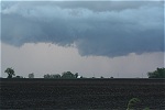
I exited at New Baden, with the intention to watch any remnant convention put on a 'sky canvas' show at sunset before heading back home. The precip core of the storm in the distance in the first image is right over downtown St. Louis, about 26 miles away. The line of cloud bases in the first image below also shows the area where the next storm of interest will develop.
A second cell developed to the east of the now-weakening St. Louis storm - and suddenly began to look interesting. As the precip core rapidly strengthened, a base developed with rising motion:
The convection remained low-topped as it moved off to the north, but the precip core continued to become more dense:
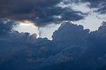
An apparent weak RFD became visible in the base, with rapid rising motion and easily discernable rotation:
  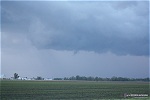
I quickly got back on the road and headed north through Trenton to Highland to catch up with the storm. Rotation and rising motion continued in the area of interest for a few minutes, but eventually precip began falling through the circulation, transitioning everything to outflow. The storm continued to produce some lowerings as it raced northeast, but in the fading light I could not discern rotation.
GO: Home | Storm Chase Logs | Photography | Extreme Weather Library | Stock Footage | Blog
Featured Weather Library Article:
|


