|
Home | Blog Index | Blog Archives | Christianity & Faith Essays | Storm Chasing Essays
Annual March 1 post
It's that time of year again! We've made it through another meteorological winter to the season of green trees and grass, warm air, longer days and most importantly to storm chasers, storms! Not only has this winter been on the mild side, most of the country hasn't been exactly storm-starved this year. February was quite active in that regard across the Plains, Midwest, South and even parts of the northeastern US. As in 2014 and 2017, I'm going into spring with a tornado already on the books.
As for chase plans, there's not anything new to report: Lord willing, I'll be keeping to the status quo of one or more Great Plains expeditions as tornado opportunities present themselves, as well as covering most Midwest events within a few hours of St. Louis. Equipment-wise, I have a couple of new things going. I purchased the parts needed to build the new lighter-weight hail shield rig for the car, so that hopefully will be complete before the first Plains trips of the year. I also passed my FAA Part 107 exam last November and have been flying a drone for winter weather coverage since then. I'll have that as another tool in the arsenal for capturing imagery and video of storms when the situation warrants.
On the documentation/logging side of things, I've settled into a routine of frequently updating this site after most chase events. Rather than a dedicated blog post for each event as in the past, I'm updating a monthly "recap" blog post on the fly, then posting that to the feeds at the end of the month. The post itself will be publicly readable prior to its "official" publication date. I'll also be updating my 2024 chase logs page after every event, linking to each event in the corresponding recap post. In the case of the more major/notable events or captures, I'll create a dedicated page as I've done in the past.
That covers the plans for chase operations this year. Now let's get into the weather!
The medium-to-long range models have been performing poorly over the past couple of weeks, so for the foreseeable future I'm reluctant to put much stock into what they are saying beyond 4 or 5 days. Earlier this week, both the Euro and the GFS were in decent agreement on a high-end upper trough to eject out into the Plains that was configured ideally for a tornado event. Models went from agreeing on that setup to completely trashing it within a few days. Instead of that monster trough resulting from the phasing of the northern and southern stream jets, the two jets are now shown maintaining as separate entities, with a much tamer/flatter northern stream trough feature affecting the Plains/Midwest this weekend. Despite the epic downgrade from what was shown earlier in the week, it still appears this system may bring some chaseworthy storms to the Midwest on Monday afternoon/evening. Some models indicate supercell and possibly tornado potential with this as the fast flow of the trough barely grazes some moisture and instability, so it's something I'm definitely watching.
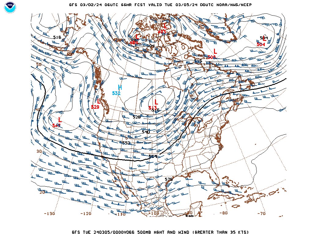
GFS 500mb forecast for Monday evening, March 4
Beyond that, the long-range models (GFS, Euro, GEFS ensemble) are plotting MUCAPE (most-unstable CAPE) frequently in the Plains and Midwest through the middle of the month (MUCAPE is my go-to parameter for discerning lightning potential in the medium-to-long ranges). There also aren't any major cold air intrusions indicated making it much farther south than the I-80 latitude, which would mean low chances for winter storms during that period. Right now, models point to the possibility of a warm and active March for thunderstorms. Again, I'm not putting too much stock in models that haven't been reliable recently, but that's just what they show for the time being. As always, I'll likely make a post or two for any big tornado signal that shows up.
As always, a big thank-you to sticking around on this site in our social media-dominated era. I genuinely appreciate your readership, stay tuned for what this season has in store!
GO: Home | Storm Expeditions | Photography | Extreme Weather Library | Stock Footage | Blog
Featured Weather Library Article:
|