|
Home | Blog Index | Blog Archives | Christianity & Faith Essays | Storm Chasing Essays
Storm chasing and photography roundup from September 2023 to January 2024
My apologies again for the long gap between storm summary posts! The last three months of 2023 were uncharacteristically quiet, with winter weather non-existent through the end of December. In addition to full-time I.T. work during that time, I passed my FAA Part 107 exam in November and have been drone-equipped for storm and weather photography since then. After the first of the year, I've been very busy with numerous winter weather events and trips, making a southern US/south Texas expedition for the third winter in a row.
Here's a summary of events covered since September of last year:
September 2023 - January 2024 Event List
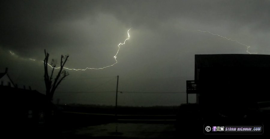
 September 5: Bourbon, MO lightning September 5: Bourbon, MO lightning
A nighttime chase to Bourbon, MO for high speed lightning. I captured two 6,000fps sequences of positive "anvil crawler" leaders.
September 26: St. Louis metro thunderstorms
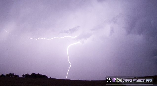
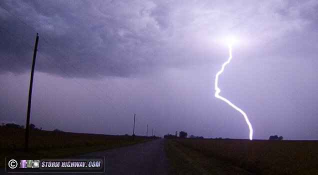
I started out at my usual spot downtown awaiting the development of new storms. When this occurred east of the city in Illinois, I moved to just north of Lebanon to watch the rapid development of this cell:
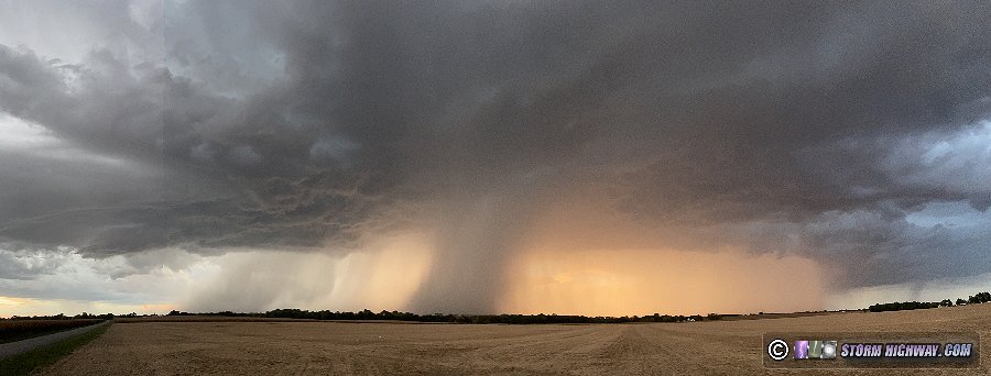
Most of the lightning was above the cloud base, with no cloud-to-ground activity until the storm had moved off to my east. At that stage, I was able to grab a few 6,000 fps high speed shots. After sunset, new storms developed to the south near I-64, and these put on quite a nice show of lightning after dark. I captured a few nice high speed shots here of positive and negative leaders between Lebanon and New Baden.
 September 27: St. Louis thunderstorms September 27: St. Louis thunderstorms
More thunderstorms moved through the city overnight. I went to my usual spots downtown, but didn't capture any photos or videos.
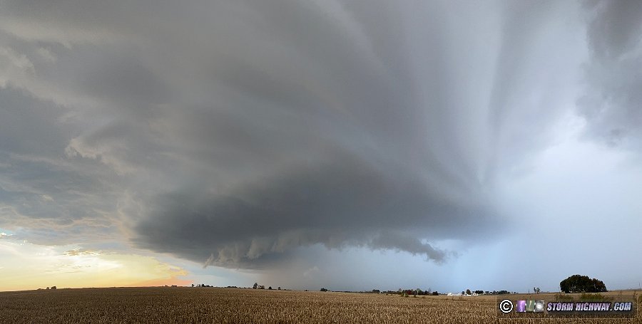
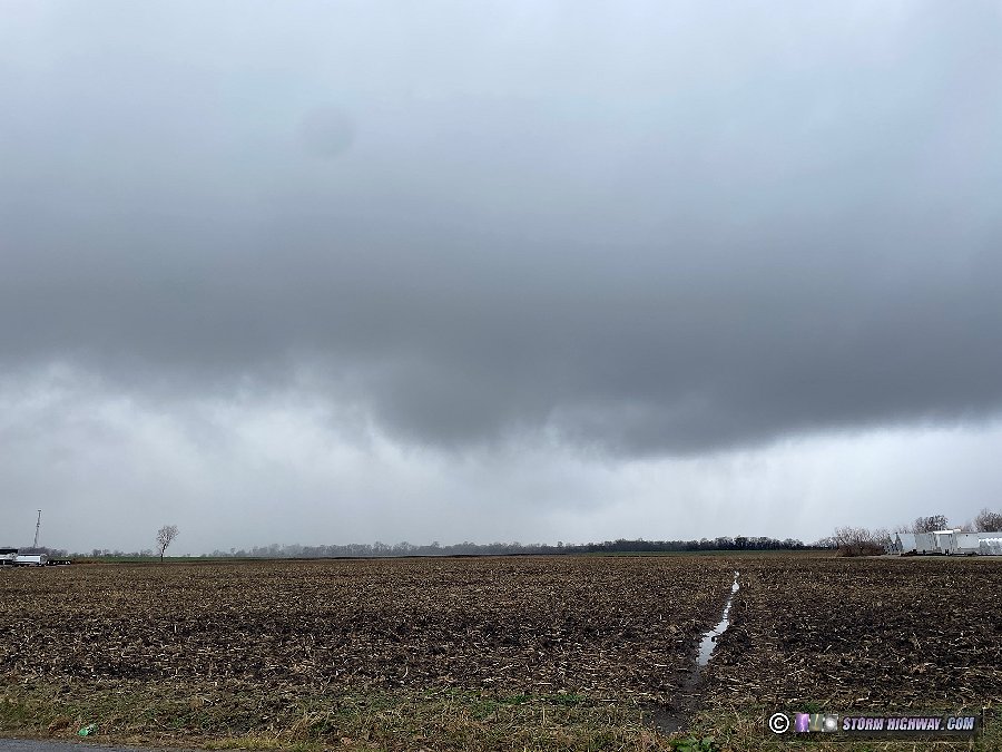
October 27: New Baden storm
I observed better-than-expected storm structure with these cells moving through New Baden, staying with them until they fell apart at Okawville. There was not enough lightning to warrant attempting high speed shots.
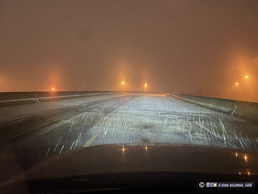
 October 28-29 Amarillo freezing rain October 28-29 Amarillo freezing rain
This freezing rain event in western Oklahoma/northern Texas Panhandle looked interesting enough to take the first long-distance winter weather trip of the season. I left in the middle of the night and drove most of the way to Amarillo, with an "overnight" stop in Shamrock where I slept from noon until late evening. I awoke at 10pm and began observing the event in the Amarillo area through the night and into the morning. I encountered icy bridges after midnight in the northern and western parts of the metro area, capturing footage on a bridge on I-40 just west of the city. This video is part of the latest compilation of icy road footage posted to my Youtube channel.
By daybreak, most icing issues had either stopped or were mitigated by road treatment crews, so I began heading home before noon. I stopped in Oklahoma City for the night and made the rest of the drive home the next day.
 December 4: New Baden, Illinois Lightning December 4: New Baden, Illinois Lightning
I had not planned on going out for this event, as models showed little in the way of storm potential due to very weak instability. I was surprised, then, to see thunderstorms developing to my west after midnight. A few visible channels peeked out of the clouds as the storms moved overhead, but I didn't manage any high speed captures. I pulled this example off of my dashcam.
 December 8: Meteor fireball December 8: Meteor fireball
I saw this meteor in the northwestern sky on the way home from work in Shiloh, IL.
 December 18: Indiana snow squalls December 18: Indiana snow squalls
Thanks to the complete lack of viable winter weather events within range of St. Louis, I haven't embarked on an icy road coverage expedition since the October Amarillo trip. As a result, when this snow squall event materialized within a 3-hour drive to the east, it was a no-brainer to go check it out. I left home at 8AM with the intention of driving to Dayton, Ohio where models had agreed a heavy band of snow would set up by early afternoon as temperatures dropped below freezing. I encountered the first snow squalls east of Indianapolis near Quarry Stone Mills. Despite temperatures dropping to 31F in the squalls and roads temporarily becoming covered, the ambient warmer air and even warmer ground prevented the roads from becoming hazardous. I noted one bridge over I-70 that was becoming slick, but this did not last very long.
After those squalls moved south of the interstate, there was nothing else approaching from upstream. Models had backed way off of the daytime snow potential before sunset, showing the temperatures staying above freezing until after sunset when the darkness would make shooting video difficult outside of a well-lit urban environment. I called it a day at 4PM and headed back home. Some high-impact icy roads did develop after sunset on I-70 west of Indianapolis, but again, it was in a rural location with few safe vantage points and no lighting to assist with capturing usable video after dark.  December 25: Spinning rain showers east of St. Louis December 25: Spinning rain showers east of St. Louis
This line of showers moving through the St. Louis metro Christmas Day was doing so in a highly-sheared environment. Despite the weak-to-nonexistent instability, these managed to produce some areas of spin on their leading edges that could have produced weak tornadoes if instability had been greater. This was one such area as the line moved through New Baden.
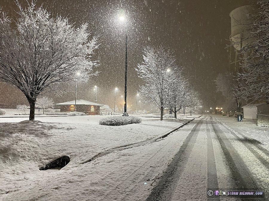
 January 5: St. Louis snow January 5: St. Louis snow
Heavy snow overcame temperatures above freezing this night, creating icy road conditions mostly east and south of St. Louis. I started in St. Charles but ended up all over the metro area - through downtown, then through Edwardsville, then down to Arnold along I-55, and finally to near Otto on Highway 21. No footage captured, but some valuable observations of an above-freezing icy road event were obtained that will be helpful for the ongoing LCR project.
Icy bridge at Pontoon Beach:
Snow downtown:
Edwardsville:
January 8: Godfrey, Illinois snow
Another above-freezing icy road event after sunset, mostly north of St. Louis. I drove up to Godfrey and spent a couple of hours shooting icy bridges along I-255. No footage captured.
January 9: Columbia, Missouri snow
I headed first to Jefferson City and then Columbia this day for a round of snow that models showed occurring in temperatures below freezing. Roads remained clear thanks to warmer-than-forecast temperatures and road treatment.
January 12: Southwest/central Missouri freezing drizzle
I left late at night on Thursday the 11th for freezing rain/drizzle forecast to begin around dawn between I-40 in eastern Oklahoma/western Arkansas up through southwestern/central Missouri. I crossed briefly into Kansas and Oklahoma initially expecting to end up along I-40, but radar and surface observations began showing greater potential up along I-70 in Missouri. I diverted through Springfield up to Boonville as icing conditions started in Kansas City and gradually migrated east. I encountered the first icing on roads south of Boonville, but found no safe spots to stop and set up a camera.

As the arctic air and subfreezing temperatures advanced eastward, I moved into Columbia to await the onset of icing there. Despite several rounds of freezing drizzle, the city avoided a major icing event as the precip ended quickly. The precip changed to snow to the east, but temperatures all the way into St. Louis were above freezing. I stayed with the snow as it moved eastward, but saw no other impacts. No footage captured.
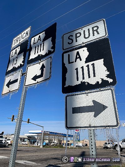
January 13-16: Texas-Louisiana-Mississippi icy road trip
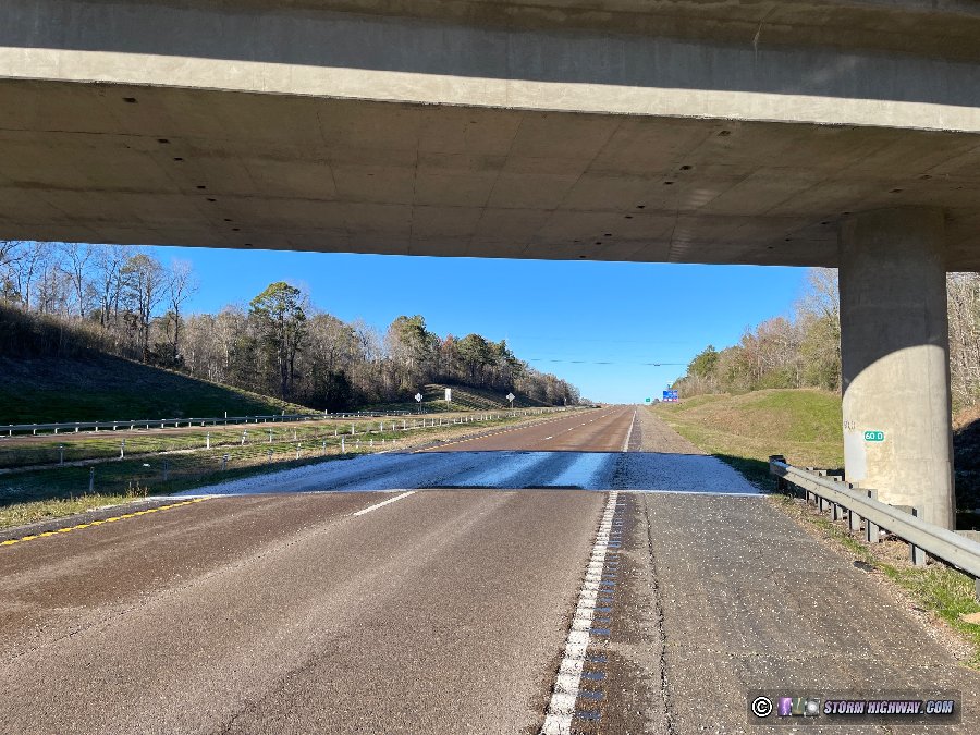
For the third year in a row, winter weather in the South prompts another trip to Texas. I left after midnight on Friday night and drove to Waco, Texas to spend the night. I awoke early Sunday morning, moving back up to the Tyler, Texas area as freezing drizzle began and started icing the roads. As this precipitation moved north into the colder temperatures, I chose to move south to Palestine in order to stay in the critical temperature range (between 20 and 29 degrees F) for bridge icing. However, the precipitation in this area was moving north, with nothing yet upstream. After monitoring the conditions for a couple more hours, I made the decision to head down to Huntsville (Texas) for the night since models showed the possibility for Houston to see freezing rain and critical temperatures on Monday.
I awoke around 9PM that night to see an area of freezing rain approaching Huntsville, with temperatures into the critical range for icing. I stopped at several locations shooting icy bridges through the overnight hours, making my way into Houston in the morning with the falling temperatures. I captured footage before sunrise on I-45 south of Huntsville near the Sam Houston statue. This video is part of the latest compilation of icy road footage posted to my Youtube channel.
As the critical temperatures moved into the Houston metro area, I spent the day shooting several icy bridge locations, capturing two videos that are now a part of the latest compilation of icy road footage posted to my Youtube channel.
Note: these were legal Part 107 drone flights (uncontrolled airspace, over grassy areas).
After I finished feeding out the final video, I ended up in Beaumont, Texas to close out the 25-hour day of shooting. The freezing rain was in progress in Louisiana, Mississippi and Alabama, but I'd reached my awake limit and needed to sleep. I awoke the next morning and headed east through Baton Rouge then north on I-55 in Mississippi where traffic maps indicated icing issues were still in progress. Clear skies, however, were rapidly melting the ice on the highways, with the exception of under bridges and where tall trees shaded the roads.
The sun was setting as I moved through Jackson, and I hadn't found any further video-worthy scenes. So, I continued north toward home. Roads deteriorated into northern Mississippi and into the Memphis metro area, but the very cold temperatures, strong winds and dark night conditions precluded staying outside to shoot anything but the most dramatic scenes (which I did not find). The lack of video-worthy scenes meant that I was able to make it the rest of the way home just after midnight.
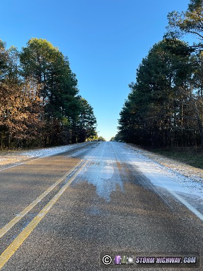
January 18: Memphis, Tennessee freezing rain
After a day at home to rest and regoup, I was back on the road south to Memphis for more freezing rain. Models and realtime data indicated that the critical icing temperatures would be mostly north of the city, so I began my monitoring of the roads on Highway 51 north. The freezing rain moved in at daybreak, creating very icy conditions on the highway. I shot several scenes along this road, capturing footage that is part of the latest compilation of icy road footage posted to my Youtube channel.
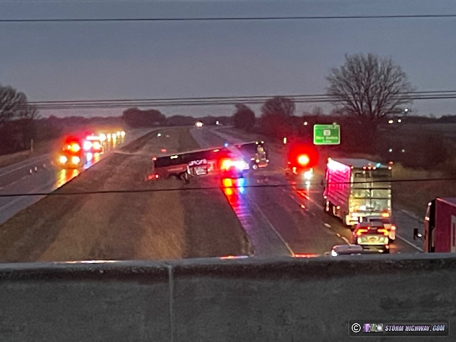
Temperatures warmed above freezing from south to north through the morning, so I moved north to stay in the critical icing temps. I didn't encounter icing again until Dyersburg and I-155 into Missouri. I encountered significantly hazardous icing in Hayti, Missouri but was a few minutes too late to capture any footage there. The above-freezing temperatures quickly arrived thereafter, putting an end to the icing threat there. To the north, skies were sunny, warming everything above freezing downstream and meaning the event was mostly over. I arrived home in mid-afternoon, making this a short out-and-back day trip.
January 22: St. Louis area freezing rain
I chose to stay in the St. Louis area for this event instead of traveling down to Oklahoma for slightly higher-impact icing due to the fact that the latter would be happening mostly at night. I left after midnight and spend the morning covering the metro area from Chesterfield, Arnold, Fenton, downtown into the Metro-East. The main roads remained mostly clear, but the side streets and county roads were treacherous. Despite the abundance of hazardous conditions, I did not capture any footage. I ended my outing before noon as temperatures rose above freezing.
< July-August 2023 Recap | All Storm Chase Logs | February 2024 Recap >
GO: Home | Storm Chase Logs | Photography | Extreme Weather Library | Stock Footage | Blog
Featured Weather Library Article:
|


