|
Home | Blog Index | Blog Archives | Christianity & Faith Essays | Storm Chasing Essays
Forecast update for April 29
The past few models runs have been trending keeping the upcoming western trough to the northern teir of US states. This suggests severe weather possible in the northern Plains during the May 5-8 period.
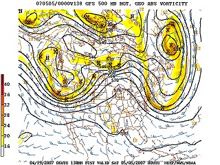
GFS 500mb forecast for May 5
The dryline looks to be active during this time in the southern Plains, but if the trough goes as far north as forecast, upper support will be lacking for the dryline down south. After May 8 or so, the models suggest a more zonal pattern (no real troughs or ridges across the USA). Zonal flow is better than ridging, but not that great for severe storms.
As a result of this information, we'll reduce the chances for a May 1-10 departure.
Based on the current outlook, this probability table charts the chance of our trip starting on a particular date:
| 2007 Storm Chasing Expedition - Departure Date Probability as of April 29 |
| May 1-10 | 17% | |
| May 11-20 | 27% | |
| May 21-31 | 27% | |
| June 1-15 | 27% | |
| No trip | 2% | |
|
GO: Home | Storm Chase Logs | Photography | Extreme Weather Library | Stock Footage | Blog
Featured Weather Library Article:
|


