|
Home | Blog Index | Blog Archives | Christianity & Faith Essays | Storm Chasing Essays
Still on the roller coaster
My last forecast post was during a time when things were looking pretty dismal for the return of chaseable weather on the Great Plains. Now, the GFS is starting to come in to line with the ECMWF on developing an OK-looking western trough and pushing it through the Plains next week.
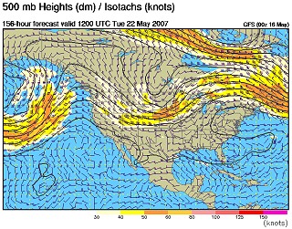
GFS 500mb forecast for May 22
Notice how far north the trough is compared to the last ones. This would suggest the severe weather area setting up from northern Kansas into the Dakotas. Now here's the problem. Here is a look at the current surface map for Oklahoma (current as of this post).
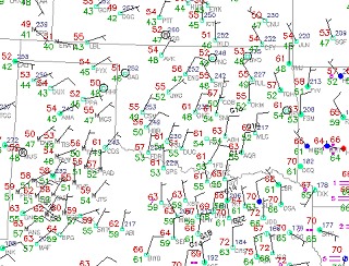
Current surface observations
Notice the wind is pushing the air southward, with widespread dewpoints in the 40s (very low for this time of year). This is due to the passage of a cold front that is surging way down into the Gulf of Mexico. The gist of this is that the moisture situation on the Plains is being 'reset' back to the drawing board. Moisture is one of the critical ingredients for tornadic supercells, so until the dewpoints climb back to the 60s and 70s underneath that approaching trough, the trough will be of little consequence other than a good round of hail and lightning-producing storms. Until the winds turn back northward, the Gulf moisture cannot flow back onto the Great Plains. For this reason, I'm not too excited about the upcoming trough.
However, things are apt to change. A quick turnaround of the winds can rapidly bring the moisture back, and the trough could end up a little further south. It's all to early to tell right now. I'm still more inclined to wait for a better trough with deeper moisture (if we do get one), so we'll keep our higher probabilities on the post-Memorial Day period.
Based on the current outlook, this probability table charts the chance of our trip starting on a particular date:
| 2007 Storm Chasing Expedition - Departure Date Probability as of May 16 |
| May 16-18 | 0% | |
| May 19-25 | 10% | |
| May 26-June 2 | 30% | |
| June 3-15 | 40% | |
| No trip | 20% | |
|
GO: Home | Storm Chase Logs | Photography | Extreme Weather Library | Stock Footage | Blog
Featured Weather Library Article:
|


