|
Home | Blog Index | Blog Archives | Christianity & Faith Essays | Storm Chasing Essays
Possible severe weather Thursday-Friday
The models are showing a good-sized mid and upper level trough moving through the midwest and Appalachians in a few days. If you remember from our forecasting excercises in the spring, these troughs can help to produce severe weather on their front quadrants due to the large-scale wind shear and lift (upward vertical motion) that usually accompany them. This trough should coincide with plenty of warm, moist air at the surface to create a ripe environment for severe storms from the Plains and Mississippi Valley through the Appalachians, Great Lakes and possibly the Northeast. Below are two graphics from the GFS model output for Thursday evening (00:00 UTC Friday).
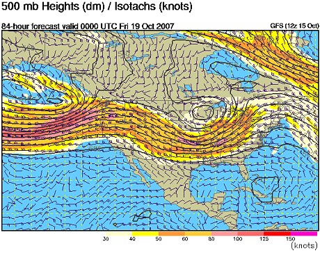
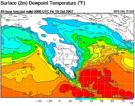
The size and depth of the trough shown seems like a good bet due to model consistency, but the critical factor will be the timing of its passage. Severe weather prospects will be maximized if the trough's shear and lift can arrive during the afternoon, when daytime heating and the resulting instability is at or near its peak. If the trough arrives overnight during the time of minimum temperatures and instability, we may not see storms at all.
Contrary to common belief, the fall season can bring with it its fair share of storms and severe weather outbreaks. October 24, 2001, November 11, 2002, November 12, 2003, November 8, 2005, November 9, 2005, November 15, 2005 and September 22, 2006 are just a few examples from recent years where not only was I out photographing storms, but seeing significant tornado outbreaks, intense lightning and flash flooding. So even though summer is over, it's never time to put away the chase gear!
Judging from the current model output, Thursday's severe weather potential seems to be centered around the Evansville-Louisville area into southwest Ohio, then moving into West Virginia and Pennsylvania (albiet while weakening) on Friday. A chase westward into Kentucky or Ohio may be in order on Thursday if conditions warrant.
GO: Home | Storm Chase Logs | Photography | Extreme Weather Library | Stock Footage | Blog
Featured Weather Library Article:
|


