Introduction to Flash Flood Waves
 One of the more fascinating and dramatic weather-related phenomena in nature is the development and progression of a flash flood wave. One of the more fascinating and dramatic weather-related phenomena in nature is the development and progression of a flash flood wave.
A flood wave is a rapid rise of water in a creek that occurs when a head of storm runoff develops and moves downstream. You can simulate a flash flood wave in miniature by pouring a bucket of water into a shallow ditch - watch how the water forms a leading edge or wavefront, just as a flash flood does in a real creek or stream. Most flash floods consist of several waves in succession - each causing additional water level rises - as runoff from each individual upstream tributary arrives. These waves can arrive suddenly and without warning.
During a strong flood, the first wave is usually a very dramatic sight and very dangerous to anyone in its path. Strong flash flood waves can cause creek rises of 8 to 15 inches or more in less than 30 seconds, usually the most impressive/dangerous of which happens when the creek is initially at normal flow. A large flash flood wave can make a creek or stream go from a trickle to a raging bank-to-bank flood in less than a minute.
Just about any thunderstorm will create, at the very least, minor wavefronts/rises on creeks and streams that it passes over. Most of these waves/rises will be inconsequential and no more remarkable/dangerous than rainwater flowing down a paved street. However, a flash flood wave does not have to reach warning-criteria intensity to be dangerous. Most flash flood warnings issued by the National Weather Service only cover events where the water is expected to overflow creek banks and subsequently affect roads and property. A flash flood event that only fills the creek basin halfway may not prompt an official warning, but can still be life-threatening for someone fishing, swimming, camping, kyaking or picnicking down in and along the creek.
A flood wave - particularly a strong one - can travel many miles downstream from its rainfall source, arriving in areas that haven't yet seen rain (and in some cases, under clear skies). For this reason, the outdoorsperson should be aware of the potential for flash flood waves if he/she plans on spending time in the basin of a creek or stream.
In this article:
Flash flood waves: stages
A flash flood can be classified as a wave, with an onset, crest and recession described in the following stages:
- Wavefront: As the flash flood runoff arrives in a creek basin, it tends to develop a 'wavefront' or leading edge that travels down the creek. This wave can travel at anywhere from a walking to faster than a running pace, depending on the curvature of the creek bed and number of obstacles (rocks, logs) in the basin. The wavefront causes a rapid rise in the water level and an increase in flow rate in a short period of time, from a few inches to more than two feet, sometimes in mere seconds! The first wave can be the most dangerous, catching fishermen and swimmers by surprise. Wavefronts can range from a subtle surge in water level to an actual 'wave' or 'wall of water' anywhere from inches to feet high - the latter being the most dangerous.
- Steady rise and crest: After the initial surge of the wavefront arrives, the water will continue to rise at a slower rate until the crest of the wave is reached, which can take anywhere from minutes to hours.
- Secondary waves: There will be a wave for each upstream tributary/ditch/water source that empties into the creek, resulting in a multiple-stage water rise downstream that an observer must be wary of. This means that before the crest of the first wave arrives, additional wavefronts may arrive, causing additional rapid surges in the water level at any time. In some cases, secondary waves can be larger and more dangerous than the first!
- Recession: Water levels will recede gradually after the crest of the last wave arrives. The observer must still be wary of waves from watersheds far upstream.
While the water rises and flows very rapidly once the wave arrives, in most cases the wavefront itself usually travels somewhat slowly down the creek (from about a walking to running pace). Typically, you can effortlessly drive ahead of a flash flood wavefront and watch it pass again and again. The exception to this is with exceptionally strong floods and in man-made drainage culverts with smooth basins and no obstacles (rocks or debris) to slow the water down. Wavefronts in smooth drainage culverts can travel faster than running pace! The wavefront and the flow behind it will often contain tree branches, leaves, trash and other small floating debris, and the water will be opaquely colored brown or black from upstream silt and mud.
There will typically be multiple waves with any given flash flood event, causing several distinct surges in water level at downstream locations. Each major tributary or watershed (such as ditches, hollows or washes) within the precipitation swath will produce its own upstream wave, which will overlap with preceding and following waves. Some of these individual waves can merge together as they travel downstream, particularly if they occur close together. The following diagram can be scaled up or down to represent anything from a large river with tributaries to a small drainage ditch with culverts:
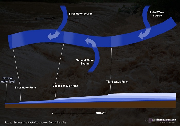 Click to enlarge Click to enlarge
Due to the fact that creeks and streams get wider as they travel downstream (as tributaries empty in to them), a flood wave will gradually spread out and weaken as it moves downstream farther away from the precipitation source. Weaker flood waves may be barely noticable more than 10 miles away from their source, only discernable by a slight silty coloring, a few leaves and floating debris, and a water rise of an inch or two every 10 minutes.
Predicting and locating a flash flood wave
Disclaimer and Safety Warning: I've been 'chasing' these events for a several years now, and aside from icy roads in the winter, no other weather hazard makes me as nervous and demands as much caution from me as a flash flood - they are (second to icy roads) the most dangerous things I encounter when covering weather stories. Consequently I would NOT recommend that a beginner take part in anything I'm about to describe. The main safety issue of a flash flood is having a quick escape route for both you and your vehicle to significantly higher ground (as in halfway up a mountainside). Getting yourself out of harm's way is simple (just walk uphill perpendicular to the creek), but it takes some forethought to make sure you also get your car (and all of its contents) out of the way. A major flash flood can fill a valley from mountainside to mountainside with more than 15 feet of fast-moving water, inundating all roads! It would be quite easy to lose your car in a flash flood if you don't plan ahead. Floodwater is also extremely unhealthy to come in contact with, often being contaminated with all sorts of bacteria and raw sewage that it has picked up along the way. In a rapidly developing flash flood, it's best to abandon efforts to save your vehicle and make the priority to get yourself out of harm's way.
Predicting a flash flood is fairly simple: locate an area experiencing persistent heavy precipitation, then identify the drainage patterns in that location to predict where the water will go. Flash floods and attendant strong waves most commonly occur with thunderstorms spanning less than a few hours, rather than long-term moderate rainfall spanning days. Weather radar is the best tool for detecting areas of heavy rainfall. Look for strong storms that either are not moving or are passing over the same area repeatedly. NEXRAD radar in the USA offers an estimated rainfall product (both hourly and storm-total) that can be useful.
Once it has been identified where the highest rainfall totals have occured or are in progress, then determine where the rainwater will flow. The worst flooding will be inside and just downstream of the area where the most heavy rain has fallen. A topographic map is helpful in identifying watersheds and predicting where the runoff will flow.
Once a suspect location is identified, the observer should start looking for visual 'excessive runoff indicators' that show signs of a developing flash flood. A flash flood doesn't start in a creek, it starts all over the landscape - and therefore the clues of an imminent flood will be everywhere you look. All of this water will soon make its way into the creek beds, where the main stage of the flash flood event begins.
Some examples of excessive runoff indicators that are signs that the runoff volume is greater than the landscape's normal drainage pattern can handle:
- 'new waterfalls' in places where they are normally not present (cascading off of rocky cliffs, etc)
- water ponding on roads and in yards
- swiftly running water filling and overflowing ditches and culverts
- ditches overflowing onto a roadway, with current strong enough to sweep gravel and other debris onto the road
When many of these excessive runoff indicators are present, a flash flood in the nearest creek basin may be imminent or in progress. A flash flood in progress will usually result in a strong, distinctive 'silty' smell permeating the air. The presence of this odor alone can be an indicator that a flood is happening nearby.
Desert 'arroyo' flash flood waves
A dramatic and dangerous variant of flash flood waves is common in arid desert and canyon country, such as the American southwest in portions of Arizona, New Mexico and surrounding regions. Here, the creeks and streams are completely dry most of the year. During the summer monsoon season, sudden and strong thunderstorms dump heavy rain in the deserts and canyons, causing flash flood waves to develop and surge down the 'arroyos' or dry streambeds. In these cases, a wavefront (often full of dirt, debris, branches and leaves) will arrive suddenly and fill the creek bed with raging water. These wavefronts are often literal 'walls' of water and debris, several inches to feet in height. Many incidents are recorded of hikers and their camps, gear and vehicles getting washed away by these sudden floods which strike without warning.
Flash flood waves: safety
Flash flood waves can be deadly for anyone caught in their path. They give little to no warning of their arrival, allowing no time for people in the path to get to safety. For the outdoorsperson planning to spend time in a river, creek or stream basin (fishermen, kayakers, campers, swimmers, etc), awareness of the weather forecast is imperative. Any thunderstorms in the vicinity can produce flash flood waves, even if the storms are far away. If flash flood potential is suspected (thunderstorms in the vicinity), move your vehicle and possessions to higher ground, far from the creek. If a flood wave is in sight, don't attempt to save your possessions - run to higher ground!
Video and photos of flash flood waves
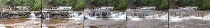
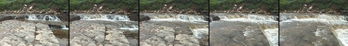
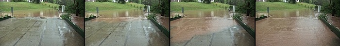
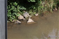
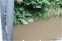
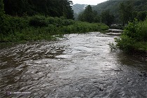
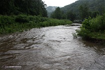
CASE 1: Primary wave arrival
The following example shows the arrival of a primary (first) flash flood wave in Mill Creek in Green Sulphur Springs, West Virginia (Summers County) on August 6, 2005. This flood wave caused a rapid rise in the water level, filling the creek bank-to-bank in a few seconds. The source of the wave was a strong thunderstorm parked on the ridges about 5 miles upstream, which produced an estimated 2 inches of rain in about 40 minutes. I had two cameras set up in the creek bed, not expecting such a rapid rise - I had to quickly get them out before they were swept away.
The following thumnail sequences show the scenes from cameras #1 and #2. The video of this event is available by clicking the images:
 Click for video Click for video
 Click for video Click for video
With this flash flood event, additional waves arrived in the 20 minutes following, causing a total rise of the creek on the order of roughly 14 to 17 inches.
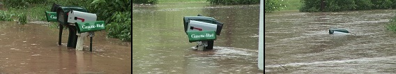
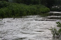
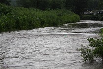
CASE 2: Secondary wave arrival
This example shows the arrival of a secondary wave during a flash flood on Scary Creek near St. Albans, WV on August 10, 2009. In this case, the flash flood was already in progress (the creek already out of its banks) when this significant wave from an upstream tributary arrived. The new wave caused an additional surge in water level of 8 to 12 inches within a span of about two minutes. Before the wave crested approximately 12 minutes later, the water levels had risen nearly two and a half feet.
This sequence of images shows the arrival of the wavefront, causing the water to rapidly surge over the low bridge crossing the creek. The video of this event is available by clicking the image:
 Click for video Click for video
The following sequence of images shows a cluster of mailboxes before the wave's arrival, followed by its rise (center) and crest (last image). Wavefront to crest time was roughly 14 minutes.
CASE 3: Weak flood waves
Stationary and slow-moving storms occurred in the mountains to the east of Charleston, WV on July 6, 2008. For the most part, the storms did not last long enough to create any significant waves.
The following pairs of images are before-after shots of two weak flood waves that I documented this day, the first in Paint Creek near Pax, WV and the second in Pond Fork near Wharton, WV. The waves took about 5 minutes each to reach their peak rises of about 7 inches, not very impressive but still interesting to watch. The creeks were continuing to rise at a rate of about an inch every 10 minutes after the initial wave, though after seeing that no significant waves were coming from upstream, I didn't stay around after the inital rises. (Click photos to enlarge)
Paint Creek, Pax, WV:
Pond Fork, Wharton, WV:
Flash flood waves: links
Major flash flood wave in Australia
This video shows quite possibly the strongest and most dramatic example of a flash flood wave in existence. It occurred February 10, 2007 on Kellick Creek in NSW Australia. Here, powerful thunderstorms dumped extremely heavy rain upstream. This wavefront is at least 2 to 3 feet high, choked with debris and racing downstream. Behind the wavefront, raging floodwaters follow. Imagine fishing or swimming in this creek and seeing this coming at you - there would be very little time to get to safety.
Lake Isabella, CA flood wave
Helicopter footage of a flood wave rushing down a dry arroyo in California.
Flood wave in Italy mountains
A flood wave cascades over several barricades along a mountain stream in Italy.
Arizona wash flood wave 1
This clip shows a significant flood wave arriving along the Nogales Wash in Arizona.
Arizona wash flood wave 2
A smaller flood wave arriving along the Nogales Wash in Arizona.
Desert 'arroyo' flood waves
These clips show minor flood waves in the desert southwest US during the summer monsoon.
Desert flood wave in Israel
Tourists film a weak flood wave as it arrives in a dry creek bed in Sde Boqer, Israel. This is a dangerous activity -a larger wave could have been deadly.
Arkansas creek flood wave
A small wave arrives in an Arkansas creek.
< Back to Weather Library
 About the Author: Dan Robinson has been a storm chaser, photographer and cameraman for 34 years. His career has involved traveling around the country covering the most extreme weather on the planet including tornadoes, hurricanes, lightning, floods and winter storms. Dan has been extensively published in newspapers, magazines, web articles and more, and has both supplied footage for and appeared in numerous television productions and newscasts. He has also been involved in the research community, providing material for published scientific journal papers on tornadoes and lightning. |
GO: Home | Storm Chase Logs | Photography | Extreme Weather Library | Stock Footage | Blog
Featured Weather Library Article:
|


