Thunderstorms triggered by industrial exhaust plumes
Power plants and large industrial facilities that emit large volumes of hot exhaust have been observed to act as triggers or 'initiators' of thunderstorms within an atmosphere primed for convective development. This is particularly true of sites with large cooling tower installations that release large amounts of steam and resultant hot air into the atmosphere.
In This Article:
- Trigger mechanism
- Observed behavior
- Visual appearance
- Associated hazards and enviromnental impacts
- Related links
Trigger mechanism
The mechanism for convective initiation by a industrial exhaust plume is unclear, although it appears probable that the phenomenon is very similar to the wildfire-associated pyrocumulus, when a focused area of lift created by the rising, warm exhaust may play a role in locally eroding a capping inversion directly above the site, allowing ambient convective avaliable potential energy (CAPE) from the surrounding atmosphere to be realized in the form of a small convective cell. Once this cell is established, it may go on to mature into a heavy rain shower or full-sized thunderstorm with lightning. It is important to note that the exhaust from the site is not the source of the convective energy, rather the exhaust acts as a trigger for thunderstorm development in a synoptic/mesoscale environment already primed for convection (IE, instability, deep boundary-layer moisture, steep lapse rates, and/or vertical and speed shear).
It appears that the meteorological conditions needed to allow the exhaust plume to act as this artificial trigger are somewhat rare, and require a delicate balance of parameters. If a capping inversion is too weak or if other synoptic or mesoscale sources of lift are present (such as a cold front or outflow boundary), storms may develop in the region surrounding the plant, negating any localized effects the exhaust plume would normally have.
Observed behavior
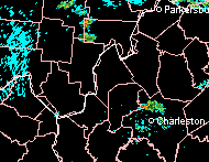
Once a convective cell has initiated over the plant, it will drift in the direction of prevailing mid and upper level winds. If mid-level capping is strong, the cell may dissipate after it moves away from the localized lift offered by the exhaust plume. It may then be replaced by a new cell directly over the exhaust plume, starting the process over again. The following radar loop from the RLX NEXRAD site demonstrates one such occurance of a series of small thunderstorms that developed over the John Amos power plant near Poca, West Virginia on July 18, 2002. The exhaust-triggered cell is on the Putnam-Kanawha county line immediately northwest of Charleston:
Click for larger loop
Notice how other storms in the area move southeastward, while the triggered storm remains anchored at the plant site. On days with weaker capping, the initiated cell has been observed to continue growing or maintaining intensity well after it has left the trigger site.
HD video clip: Watch an HD time-lapse of a triggered convection event
Again, notice in the video how the convective cell remains stationary just downwind of the plant site, just as the radar image from the earlier (separate) event demonstrates.
Visual appearance
The triggered cell appears as towering cumulus or cumulonibus with its cloud base physically attached to the exhaust plume from the trigger site (Watch an HD time-lapse of a triggered convection event). The following photographs were taken at the John Amos plant at the time of the radar images shown above. This cell was producing heavy downpours and lightning at the time of these images.
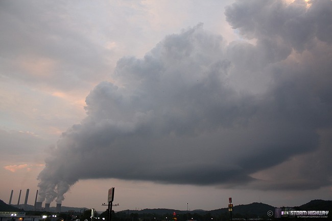
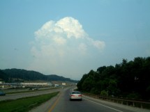
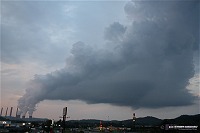
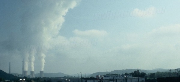
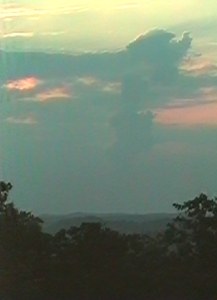
(click images to enlarge) BELOW: Panoramic photo of an exhaust-triggered convective event at the John Amos plant on July 18, 2002, viewed from the west side of the site. The storm was producing lightning and heavy rain at the time of these images. Note the continuous cloud base connection to the cooling tower exhaust.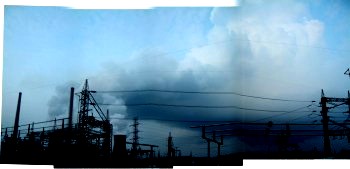
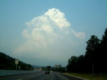
BELOW: A panoramic view of the convective cell from 3 miles to the south. The John Amos plant is behind the hill on the far left (note the top of the stacks visible). The exhaust plume remains attached to the base of the cumulonimbus cloud. The heaviest rain and lightning was occuring in the region marked by the lowered cloud base near the center of the image.
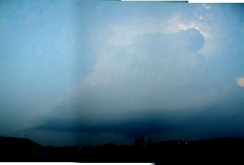
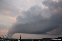
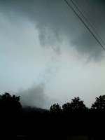
BELOW: Views of the convection from approximately 6 miles to the west of the site.
BELOW: Photos of an exhaust-triggered convective event at the John Amos plant on June 14, 2008, viewed from the south side of the site.
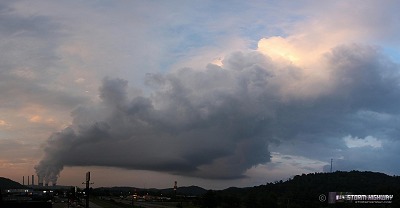
(Watch an HD time-lapse of the above event)
Associated hazards and environmental impacts
As mentioned previously, the incidence of triggered convection over any given exhaust plume site appears to be dependent on a delicate balance of meteorological parameters, and therefore is generally a rare event only encountered a few times per year. It is unlikely that these events have much notable consequence in the broader scope of climatological data for the surrounding region.
Nonetheless, triggered convection does introduce a slightly higher probability of several weather-related hazards for the areas within a 20-mile radius surrounding the exhaust plume sites (particularly areas east, southeast and northeast of the sites in a typical North American region with a general westerly flow aloft).
Flooding and Heavy Rainfall
The main threat from these artificially-initiated thunderstorms is persistent heavy rainfall and flash flooding. Triggered convection can either remain stationary or exhibit 'training' over the same areas downwind of the exhaust plume site.
In the case of the example observed at the John Amos site in July of 2002, a special weather statement was issued by the National Weather Service, indicating that radar estimates showed the cell had dropped as much as 3 inches of rain in the Cross Lanes area, immediately east of the plant. Rainfall amounts of that magnitude in a short time frame usually indicate that localized flash flooding is possible.
BELOW: Long-duration heavy rainfall underneath the triggered thunderstorm at the John Amos plant prompted the NWS to issue statements advising the possibility of flash flooding.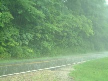
Lightning
A slight increase in recorded cloud-to-ground lightning strikes in the regions downwind of the trigger site would be a reasonable assumption.
Cloud cover
An increase in overall cloud cover is present year-round for regions downwind of the exhaust site, particularly in areas closest to the plume. The resultant reduction in direct sunlight may have a small, localized effect on vegetation growth and surface temperatures.
Other precipitation types
Large exhaust plumes have been observed to trigger and/or enhance frozen precipitation in the wintertime. A slight increase in snowfall instances and total accumulations in the downwind regions of the plume sites could be expected.
More photographs
ABOVE: Steam rising from the cooling towers at the John Amos plant during a non-convective day shows the size of the typical plume by itself.
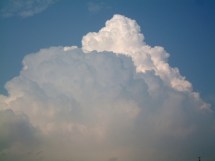
BELOW: A considerably large triggered cumulus congestus formation above the John Amos plant, viewed 6 miles away from the west in Scott Depot, WV. The plant location is identifiable by the small 'funnel' of exhaust below the right side of the cloud.
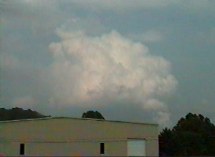
BELOW: This image shows the same cloud formation as the above image, 10 minutes later, viewed 2 miles away from the south. The cloud has started to dissipate as midlevel winds push it to the east.
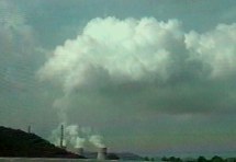
BELOW: A cumulus formation takes shape above the plant. The two narrow main stacks to the left of the cooling towers are releasing burning coal exhaust.
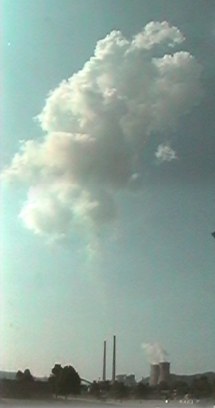
BELOW: This image shows a view from a mountaintop in Charleston, 15 miles to the east of the John Amos site. The narrow exhaust plume has risen to significant heights, breaking through a layer of what appears to be high cirrostratus clouds.
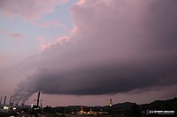
BELOW: Fog formations underneath the John Amos thunderstorm in July 2002 as a result of the heavy rainfall.
Related links
Triggered convection event over oil refineries in Wood River, Illinois
Article by storm chaser John Farley documenting triggered convection over petroleum refineries along the Mississippi River.
Artificially generated snowfall event in Dodge City, KS
Article by the NWS Dodge City office documenting a potent localized snowfall event with accumulations generated by a combination of exhaust from nearby slaughterhouses and a power plant.
Artificially generated snowfall event in Green Bay, Wisconsin
Article by the NWS Green Bay office documenting a localized snowfall event with accumulations generated by exhaust from a nearby industrial site.
 About the Author: Dan Robinson has been a storm chaser, photographer and cameraman for 34 years. His career has involved traveling around the country covering the most extreme weather on the planet including tornadoes, hurricanes, lightning, floods and winter storms. Dan has been extensively published in newspapers, magazines, web articles and more, and has both supplied footage for and appeared in numerous television productions and newscasts. He has also been involved in the research community, providing material for published scientific journal papers on tornadoes and lightning. |
GO: Home | Storm Chase Logs | Photography | Extreme Weather Library | Stock Footage | Blog
Featured Weather Library Article:
|


