|
Home | Blog Index | Blog Archives | Christianity & Faith Essays | Storm Chasing Essays
Appalachian upslope snowstorm to start 2008
A strong cold frontal passage is the start to our new year's weather, turning winds northwesterly with subfreezing temperatures and abundant low-level moisture - prime ingredients for a strong upslope snow event for the central Appalachians. The following graphic from the HPC outlines the probabilities for at least four inches of snow across our region:
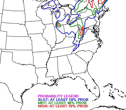
Most areas in the mountains will likely exceed the four inch mark, with some locations in the northeastern WV higher terrain getting a shot at a foot or more of accumulation.
Widespread icy bridge event on December 31
The freezing fog/freezing drizzle that created the surprise icy bridge accident episode across the Kanawha Valley yesterday morning (including at the Oakwood/Fort Hill Bridge) was part of a widespread outbreak of similar conditions across the midwest and northeast. Ice on bridges and overpasses created havoc in Kentucky, Pennsylvania, Ohio, Virginia and Maryland at the same time as in West Virginia - including in Cincinnati, OH, Lexington, KY and Allentown, PA. Numerous news articles from yesterday morning describe some of the incidents.
Since I totally missed this event (as did the NWS, local meteorologists and the Department of Highways), out of curiosity, I pulled some archived images from the StormCam, which has been focused on the deck of my back porch to monitor precipitation. The edges of the decking will usually accumulate ice and snow at roughly the same rate as bridges and overpasses in the area, so I figured that the deck would have shown some of the icing. The time-lapse video from the WCHS towercam shows the fog was a valley-fog type setup, with most of it initially concentrated over the river. But just before daybreak, the fog expanded to cover more of the valley. It appears that the fog did not reach my camera location until right at sunrise, as no ice is apparent on the deck at the start of the day. However, patches of ice can be seen forming on the deck just after sunrise.
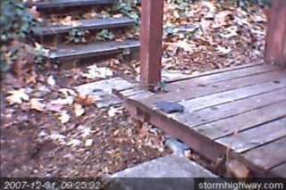
I took the archived images from yesterday and compiled a 24-hour timelapse that shows the ice on the deck beginning to form.
GO: Home | Storm Chase Logs | Photography | Extreme Weather Library | Stock Footage | Blog
Featured Weather Library Article:
|


