My work is, at this very moment you are reading this, generating the most income it ever has in my career. Yet, I was forced to shut down my successul operation, against my will, due to one cause alone: 95% of that revenue is being stolen by piracy and copyright infringement. I've lost more than $1 million to copyright infringement in the last 15 years, and it's finally brought an end to my professional storm chasing operation. Do not be misled by the lies of infringers, anti-copyright activists and organized piracy cartels. This page is a detailed, evidenced account of my battle I had to undertake to just barely stay in business, and eventually could not overcome. It's a problem faced by all of my colleagues and most other creators in the field.
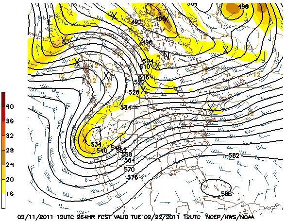
Some very nice pictures are being painted by the last few model runs of the Euro, the GFS and its ensembles. If they turn out to be right, we could almost move the 2011 start date for meteorological spring up to tomorrow rather than March 1, as the weather pattern over the US will be of the seasonal 'transition starter' type that we'd normally see a few weeks later. Along with a strong warming trend beginning tomorrow for the lower 50% of the US, a persistent western upper troughing pattern is shown developing into the later half of next week and staying in place for several days. This should not only result in an even more robust and entrenched warmup for the central/eastern US, but introduce the possibility of thunderstorms - maybe even an storm chase day or two for the Midwest and Great Plains.
GFS Forecast for Tuesday 2/22
Now again, we all know these models are not reliable more than 5 or so days out - but the big western trough is showing up with consistency and agreement among multiple models into late next week, which lends a little more believability to something like it happening. At some point, we do know that if such a trough does develop, it eventually will either move eastward or shed 'shortwaves' of energy to its east, increasing the chances for thunderstorms over the Plains/Midwest. Of course, deep moisture will not be as available as it is in later weeks/months ahead. That simply means a lesser chance for tornado outbreaks, but reasonable chances for thunderstorms. For a lot of storm chasers (including me) that's a welcome thought.
If the large trough comes through as advertised, we will be looking at a brief cold spell on its back section, possibly even a winter storm tracking somewhere through the nation's midsection. Any cold snap and snowpack, however, should be much shorter-lived and less brutal, something we'd expect as February moves into March.
At any rate, we've got some interesting weather to keep an eye on in the coming weeks.
Will watch this one with intrest Dan !! - Posted by Mick from UK
Web Site Design and Internet Marketing by CIS Internet
From Dan: Please Read
To my regular readers, I offer my apologies for this heavy-handed notice. Unfortunately it has become necessary, so please bear with me!
Please don't copy/upload this site's content to social media or other web sites. Those copies have been a critical problem for me, seriously harming this site and my photography/storm chasing operation by diverting traffic, viewers, engagement and income. "Credit" and "exposure" does not benefit this site or my operation, rather they threaten my ability to cover my operating expenses. Please read my full explanation for this notice here.
Before continuing, check each box to agree to and acknowledge these two statements:
Click this button to finalize this acknowledgement: