 Hurricane Frances rattles Florida: Storm makes landfall as a Category 2: September 6, 2004 Hurricane Frances rattles Florida: Storm makes landfall as a Category 2: September 6, 2004
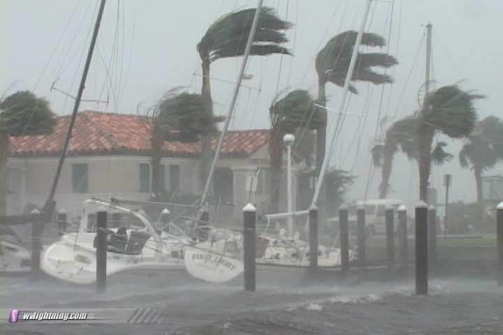
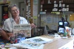
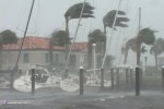
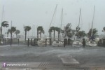
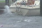
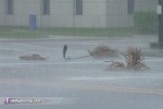
ABOVE: Hurricane Frances rips into the city marina at Fort Pierce, Florida on Saturday. This marina and most of the boats were destroyed a short time later.
EXPEDITION VIDEO: Frances wreaks havoc on Florida: Storm Highway Video Clip
FORT PIERCE, FL - Hurricane Frances made landfall on Florida's east coast on Saturday and Sunday, then moved across the Appalachians, bringing flooding to West Virginia, Ohio, Virginia, North Carolina and Pennsylvania. Meanwhile, Hurricane Ivan could be the next tropical rainmaker to affect our region next week.
Below is a report from the storm chase expedition to Florida into the eye of Hurricane Frances. Photos can be enlarged by clicking on each thumbnail image.
THURSDAY: I departed WV at 10AM Thursday with a target of inland Florida, in anticipation of Cat 4 or 5. Brought the usual chase gear along with two 24-packs of bottled water and 12 cans of canned food. A call to Doug K. as I passed through Savannah advised of the fuel shortage, so I planned to begin topping off my tank every 30 minutes starting in Jacksonville at 10PM. Began encountering northbound evacuation traffic on I-95 in southern Georgia - nearly bumper-to-bumper, but moving along at a good pace:
Video captures:
It was business as usual in Jacksonville - a hot, humid Florida night with no indications of the buzz on I-95 and to the south. Traffic wasn't bad and gas stations had no lines or empty tanks, but hotels were booked. Finally found a hotel in Lawtey, spent the night and left Friday morning heading south on 301.
FRIDAY: Today, the forecast strength was much weaker, and landfall was pushed back to Saturday afternoon or night. With a full day now to get into position and find shelter, I decided the coast would be a doable target. The plan was to avoid I-95 evacuation and corresponding fuel shortages by taking a route through the center of the state away from major highways, topping off every 30 minutes. The route would take longer but there was plenty of time. The plan worked for the most part, no fuel problems or long lines until I got to Melbourne.
On the way to Melbourne in the late morning, I received a warm welcome at the family-owned Holopaw Restaurant and general store in the small town of Holopaw. The restaurant cooks were getting ready to close up for the storm, but were kind enough to offer me one last sausage, egg and grits breakfast before packing up. The owners even turned out to be West Virginia natives! A big thanks goes out to the Holopaw Restaurant for their hospitality.
Video capture:
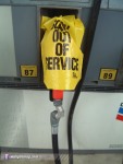
My last fill-up was in Melbourne on Friday at one of only 3 stations I saw open in town. Plastic-wrapped pump nozzles were a common sight for anxious motorists not only in Melbourne, but across most of eastern Florida:
Digital photo:
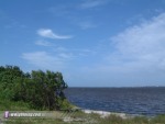
I knew I had to conserve fuel, so I wanted to find a place to stay put until the forecast track became clearer. I drove to the bayside near Palm Bay and sat for several hours watching high cloud bands begin to rotate in:
Digital photo:
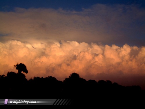
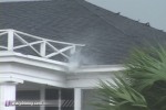
Melbourne area hotels were booked, so I was surprised to see the Days Inn parking lot with only a few cars. Are they open?? Yes!!! The room was inexpensive. The only other people at the hotel were media crews (TWC, CNN, etc). At dusk, Frances' first band of precipitation approached with beautiful sunset-lit hard convection, with an occasional rainbow near the cloud tops:
Digital photos:
The band moved in just after sunset without much fanfare, it looked worse as it approached than it actually was. Stayed up to see the 11PM NHC advisory then called it a night.
SATURDAY: Awoke at 5AM to a stronger band moving through, gusts roaring outside. Saw the 5AM advisory and knew I needed to adjust south to Fort Pierce. Started to pack up as winds and rain pounded outside. I thought to myself, 'I'm surprised we still have power here". Seconds later, the lights flickered - I grabbed the camera and ran outside. Nearly continuous power flashes - orange, green, blue - to the south (see video clip):
Video captures:
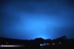 
These arcs must not have been on our circuit, as our power was unaffected. This rain band, as with many of the outer bands, was surprisingly strong and caused formidable damage very early on.
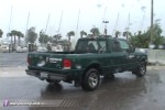
The band subsided at sunrise, and it was back to packing. But not before a bit of a panic - my room key card would not work. The LEDs on the door lock didn't even come on, the lock was dead. The desk clerk on duty on Friday said that the hotel personnel would be gone today, and I thought I was stuck outside with my laptop, second camera, and clothes in a hotel that would likely be flooded in 12 hours or so. To my great relief, I found the lobby unlocked and a couple of attendants and maintenance workers inside, who used the manual key to open my door. They said the windblown rain shorted the lock. Whew. After a quick shower and preflight check of gear, I was heading south for Fort Pierce with a full tank of gas.
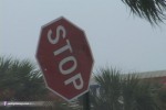
I used up 1/4 tank getting to Fort Pierce at 8AM. Once I arrived, I did a quick survey of the town for potential shelter, safe filming spots, danger spots to avoid - as well as weak structures, signs and objects that might fail in the strong winds. Again, I wanted to limit driving as much as possible so I would have a chance to get out once the storm was over. Met some storm chasers from Texas, California and Mississippi who had found a parking garage in town, we agreed to base there for the eyewall.
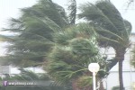
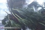
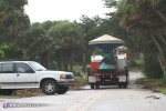
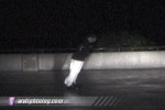
Bands with very strong winds rotated in around 10AM, so I made my first filming stop at the marina. The wind whistling through the sailboat masts was an incredible sound (see video). Big waves smashed into the pier even though we were on the bay. I recorded a gust to 72mph and many more above 60mph here:
Video captures:
Digital photo:
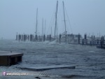
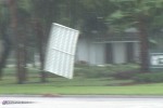
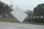
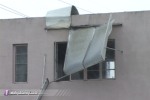
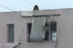
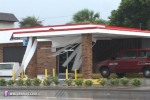
These are the last photos of the intact marina, as the facility was later destroyed as Frances' eyewall moved ashore. With winds this high I felt that structural failures would be starting, so I headed back to the business district on the south side of town. Many large signs had already blown out or fallen over. I found a small business with big aluminum awnings on its second floor windows. A couple of the awnings had been ripped away and the remaining ones weren't far behind, so I parked and filmed for a while as three of the awnings failed and went sailing over the road, barely missing cars! (see video clip)
Video captures:
  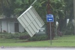 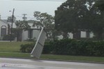
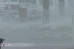
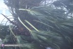
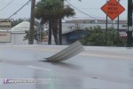
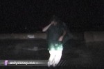
At noon, I left this spot looking for more activity, but even this early, most of the damage to signs had already been done - and landfall was still 12 hours away. Winds still gusted above 60 to 70mph, flailing signs and traffic lights, battering palm trees, ripping siding and paneling from buildings, and sending draining water from gutters upward instead of downward:
Video captures:
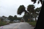
With a 1PM curfew approaching, I did one last check of the town before heading to the parking garage. Saw the DOWs on a bayfront road, where palm trees were leaning over the road.
Video captures:
Saw many media trucks and several storm chasers whom I couldn't identify in passing.
The parking garage was our home for the next 20 hours. It was a great spot with protected, elevated views in three directions. A solid concrete wall on one side and inner walls shielded us and our vehicles from wind and debris, while giving us a clear view out to film.
Digital photo:
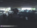
The upper level was easily accessable, and I was able to drive up to the top easily to take wind measurements.
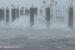
While the view was optimal here, there unfortunately wasn't much more going on outside within our view. Most everything that was going to fall had already fallen. The western eyewall started passing over right at dusk, and winds intensified very slowly but steadily through midnight. I went to the top level to get a taste of the now 65mph sustained winds gusting to 80mph:
Video captures:
At dusk, another tense moment. I was parked on the top level filming to the west, with the truck facing north into the wind, now 40-50mph sustained and getting stronger. When I went to start up to move back below, click-click-click - dead battery! All of the frequent starts and short drives to conserve fuel had drained my battery (not enough alternator recharge time). I had a jumper pack, but no way could I open the hood facing directly into 50mph winds! That is, unless I didn't want to see it rip off and sail away on its way to Miami. I considered connecting the jumper pack into the cigarette lighter, but was unsure of polarity or fuse rating for the circuit. I could not risk a blown fuse as the fuse panel is also under the hood. The other option was to leave the truck on the top level through the duration of the eyewall. Not a good option. I decided to push the truck 20 feet to the sloping ramp and coast downhill enough to where I could turn away from the wind. But when I put the truck in neutral and put one leg outside to push, the wind immediately began pushing the truck backwards. OK, this is not going to be easy. I took a deep breath, grit my teeth and leaned into the doorframe with all I had. It worked!! I started moving forward. I made it to the base of the slope and coasted around facing southeast. Even at that, the hood was not enjoying the winds as I rushed to hook the jumper up and start the engine before the next gust. Made it through this mini-crisis, and left the engine running for a while to recharge.
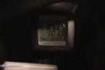
SUNDAY: The most intense winds reached us at midnight. During one burst, I drove up to the upper level and recorded 89MPH sustained with a gust to 102mph, and many more in the 90-95mph range (see video clip above for dashcam video of this event)
Video captures:
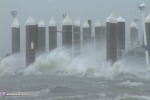
After I returned below, an even more intense burst of wind slammed us with what we estimated to be in the 110-115mph range. This period of peak wind bursts only lasted ten minutes or so before slowly tapering off. One of the most remarkable things we saw during the eyewall was lightning! Infrequent, maybe a flash every 5 minutes or so. We saw at least 15-20 lightning flashes, easily distiguishable from the occasional power flashes from arcing power lines.
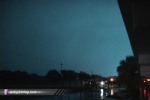
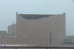
While we experienced a direct hit from the eye in Fort Pierce, we never experienced a true calm. Within the hours starting at midnight, winds shifted from the north, to northeast, then east, then southeast, then south around dawn. The most intense winds were out of the north within the western eyewall. At dawn, we could now see some of the damage that had been done overnight, the worst of which was to a large building downtown:
Video capture:
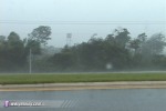
At 11AM, after eyewall winds subsided and weaker inner bands resumed, I decided to try heading home. I had 1/2 tank of gas and thought I could make it as far as St. Augustine. Surely, I thought, there would be gas that far north. Stopping at a rest area a few miles up I-95, I ran into Jesse Bass, Mark Sudduth and crew from hurricanetrack.com. They had 1/4 tank and were also counting on finding gas up north. I resumed my trip a few minutes ahead of them. The drive north was a mixture of relative calm with light rain to heavy rain bands with very strong winds gusting to over 60mph:
Video capture:
I watched debris patterns as I drove, looking for damage to begin to taper off - any sign that I could be approaching areas with power - and gas. To my surprise, damage severity wasn't decreasing at all as I drove north. Uh-oh. Got to St. Augustine - still heavy damage, no power, and no gas! Jacksonville HAD to have gas, I thought. But could I make it? It would be very close, but I had to try. My gauge needle was pegged at empty as I entered the Jacksonville city limits. Folks, prayer works. I must have only had a mile or two of gas left as long as I drove pegged at empty, but I made it. A gas station in southeast Jacksonville was out of 87 octane, but had 89 and 93. A tank of pricey 89 works for me, I was so overjoyed to be filling the tank that I didn't care about it costing over $35. Unfortunately I knew the hurricanetrack.com crew would not make it with 1/4 tank, as I barely made it with 1/2. Wind was generally southerly which helped my fuel economy. Just a few minutes more of driving around in Fort Pierce and I surely would not have made it.
After that I was home free, crossing the border into Georgia, where I finally was out of all damage and evacuation zones, and began seeing open restaurants and signs of life again. A stop at Waffle House was a welcome change to two days of cold canned pasta and lukewarm water. Next time I'm bringing more variety.
In all, a great experience. Learned some new lessons. Much better than Isabel despite the long trip. Looking forward to the next one!
MEDIA INFO: Please contact Dan Robinson via cell phone at this link for more information.
HURRICANE LINKS: National Hurricane Center | Satellite Imagery
| View 1,604 storm chases: |
| by year: |
|
| by type: |
|
|
|
|
My work is, at this very moment you are reading this, generating the most income it ever has in my career. Yet, I was forced to shut down the professional side of my successul operation, against my will, due to one cause alone: 95% of that revenue is being stolen by piracy and copyright infringement. I've lost more than $1 million to copyright infringement in the last 15 years, and it's finally brought an end to my professional storm chasing operation. Do not be misled by the lies of infringers, anti-copyright activists and organized piracy cartels. This page is a detailed, evidenced account of my battle I had to undertake to just barely stay in business, and eventually could not overcome. It's a problem faced by all of my colleagues and most other creators in the field. |
GO: Home | Storm Chase Logs | Photography | Extreme Weather Library | Stock Footage | Blog
Featured Weather Library Article:
|


