RELATED ARTICLE: Artificially-Initiated Thunderstorms
In Charleston, a small stationary cloud is almost always visible on the western horizon. This is the indicator of the presence of the large John Amos power plant, located 15 miles west of downtown.
Steam continuously flows from the John Amos' 3 large cooling towers, pumping heat and moisture into the atmosphere that later condenses into clouds at higher altitudes. Typically the cloud formation remains a small, cumulus-like plume above the plant. However, varying atmospheric conditions often cause the plume to transform into large, spectacular formations.
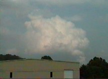
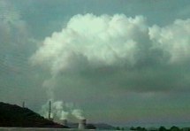
The top image at right shows a growing cumulus congestus-like formation above the plant. Note that the two narrow main stacks to the left of the cooling towers are apparently releasing burning coal exhaust, which contains particles that may encourage condensation.
 The first image at left shows a considerably large cumulus congestus above the plant, viewed 6 miles away from the west in Scott Depot, WV. The plant location is identifiable by the small 'funnel' of exhaust below the right side of the cloud. The atmosphere was somewhat unstable at the time, and many showers and small thunderstorms were popping up around the area.
 The second image at left shows the same cloud formation as the above photo at left 10 minutes later, viewed 2 miles away from the south. The cloud has started to dissipate as higher-level winds push it east.
The second image at right is the view from a mountaintop in Charleston, 15 miles to the east. The narrow plume has risen to signifigant heights, breaking through a layer of what appears to be high cirrostratus clouds.
Is it possible for a mechanism like this to induce large-scale convection and trigger a thunderstorm in unstable atmospheric conditions? Or, is it possible for the plant produce a plume large enough to become a man-made thunderstorm with precipitation and lightning?
At times during winter, the plant produces a persistent, solid layer of low stratus clouds. These stratus clouds often stretch 20 to 30 miles away, with a width a few miles across at the farthest point, then funneling down into a narrow stream that finally ends directly over the plant.
RELATED ARTICLE: Artificially-Initiated Thunderstorms