
 March 19 severe thunderstorms - Charleston, WV: March 19, 2008 March 19 severe thunderstorms - Charleston, WV: March 19, 2008
ABOVE: Ominous shelf cloud over downtown precedes Wednesday's storm (click to enlarge).
CHARLESTON, WV - For one of the first storm events of the 2008 storm season, March 19 didn't turn out all that disappointing. Thanks to just an hour of late afternoon sunshine, the atmosphere in the Charleston area destabilized enough to allow an incoming line of storms to suddenly intensify past severe limits over downtown. Today's local 'chase' of this event took me first to Dunbar, where I observed the initially weakening line of storms (more accurately 'showers', as I saw no lightning) from the hilltop in Grandview cemetery. The impressive arcus/shelf cloud formations were already taking shape here. In the first photo below, the WVAH TV tower is visible in the distance (this is the tower site where I've been heading in recent years to catch upward lightning strikes).
  
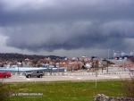
The southern sections of the squall line seemed more intense than what was about to hit the Dunbar area, and there was a little bit of lightning left there - so I decided to head back to Charleston ahead of it. The shelf cloud formations coming into Charleston were quite dramatic as they loomed to the west. I stopped at Greenbrier Street to grab a few shots of these features moving in over downtown:
Radar showed convection pulsing in intensity just to the south, on course to move over Kanawha City. I drove to the Cambpell's Creek area to watch this activity approach. As I did, the section of the line over Charleston became dominant, at which time I turned around. The precip onset was sudden and intense. Yeager Airport showed 53mph sustained winds with a gust to 84mph as the line hit.

That kind of wind can easily produce damage, so I headed back towards the airport vicinity to see what I could find in the swath of the storm. I found some extensive tree damage in a very compact area along Coonskin Drive, just east of the airport runway. Although the damage path was very narrow and I found a tree trunk snapped off halfway up, the debris pattern did not look indicative of a tornado. Furthermore, there was no damage at all that I could see in the woods on the other side of Coonskin Drive that would indicate a tornado track. Most likely an intense gust of straight-line winds descended the runway embankment and struck the row of trees at the base of the hill. More tree and power line damage was reported in Clendenin and Pinch.
 
|


