
|
||||||||||||||||||||||||||||||||||||
ST. LOUIS, MO - The system that brought the prolific tornado outbreak to the Plains on May 29 moved into the Midwestern states on May 30. The following is a journal of the day's chase. Times (CDT) are approximate. Photos can be enlarged by clicking on each thumbnail image. I started the day in Joplin, MO, fairly rested up after the long chase in Oklahoma the previous day. By midday, cells were starting to fire in Oklahoma and Kansas. I stayed in the Springfield area waiting for the new squall line to reach me. I contemplated taking off south after the tail end charlie cell west of Muskogee, but decided to stay put. With helicities better up around St. Louis and cells beginning to isolate and head that way, I finally jumped on I-44 and headed east for the best looking storm at the front of the line. Easy intercept, or so I thought. The cells were screaming east-northeast, I didn't catch the storm until nearly into the St. Louis metro - nearly 3 hours from Springfield! My storm looked impressive on radar, and had classic supercell structure at a distance - bell updraft tower, long inflow tail, low-level inflow was strong. I finally got under the base at Union, MO to see a nice clear slot, but the cell was getting cut off by cold air from another storm to the south. A huge striated shelf cloud materialized in front of the complex, so I decided to stop across the river from downtown St. Louis and get a shot of the mothership coming over the arch. The shelf cloud dissipated and moved off to the northeast, so no arch/storm shot was to be had. Took a few digital shots for posterity:
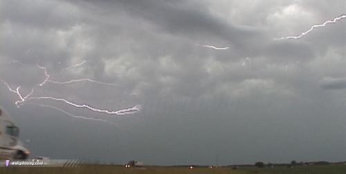
 The big 'squall line of the year' was starting to take shape now just a few miles to my east in Illinois, and I wanted ahead of it at least by central Indiana. I knew that the race with the squall line would not be easy. I jumped on I-64 and gave chase, stopping once for some lightning video ( RealVideo clip, 833KB ):
    The squall line was rocketing eastward. I could not catch the line at 65-70mph on the interstate. It was unbelievable how fast this was moving. I gave up the pursuit at Lexington, Kentucky after too much standing water and fallen trees on the interstate to continue safely. What a mess. So, the squall line wins the race this time. WxWorx showed parts of the line moving east as fast as 81 MPH. I spent the night near Morehead, slept in, and made it home by noon Monday. A big thanks goes out to Dave Crowley for nowcasting support. May 30 marked the end of my second trip to the Plains from West Virginia, and was my last chase of the season. Or so I thought. I was more than satisfied with the 8 tornadoes I was blessed to have captured thus far, and I was just beginning to get back into the groove of 'normal' life. That is, until another potent system began showing up in the forecast models. Another strong negatively-tilted trough was swinging toward the Plains, a surefire setup for severe storms and tornadoes. Before the first week of June was over, I was already ready to get back on the road westward for an 'extra' trip to Tornado Alley - my third one of the season. I left on June 8, stayed overnight in Mount Vernon, Illinois and made it to Colby, Kansas by nightfall on the 9th, barely missing a severe weather event in Colorado. The 10th would be the first chase of Plains trip number 3. NEXT EVENT: Back in the Plains for severe weather on June 10
GO: Home | Storm Chase Logs | Photography | Extreme Weather Library | Stock Footage | Blog
Featured Weather Library Article:
|
||||||||||||||||||||||||||||||||||||


Web Site Design and Internet Marketing by CIS Internet