
|
||||||||||||||||||||||||||||||||||||
The Lord can do anything, including bringing summer-like thunderstorms to West Virginia in the middle of January. Just four days after receiving 7 inches of snow, most of the state was greeted with a bizzare turn of the weather with an all-night series of thunderstorms on Wednesday night. Snow was still covering the ground in many places when a storm system, fueled by unseasonably warm temperatures (caused by northward transport of air from the Gulf of Mexico by a strong and correctly positioned jet stream) moved across the state in the overnight and early morning hours. The storms produced fairly frequent cloud-to-ground and intracloud lightning flashes, unheard of for the middle of winter in Appalachia. This night, I was working late at the office and consequently had access to the neccessary weather data. At midnight, doppler radar showed the north end of a line of storms in eastern Kentucky, moving slowly east-northeast. Some of the best cells in the line seemed to be on a course for the Mason County area, so at 12:30 AM I headed west on US 35. There were several active cells visible by the time I reached Winfield. Flash rates were fairly decent, about one every minute or so. I knew I'd need to be facing south to take photos, so I crossed the river and moved west on Rt. 25.
I finally reached the first cell at about 1:00 AM in Buffalo, WV, and at that point could see more active cells to the west. I kept driving until I reached a point about 5 miles inside of Mason County, when a cell just to my south started firing off bright cloud-to-ground strikes. Despite the relatively heavy rain, I immediately pulled off the road and set up the camera and its crude umbrella shelter and began shooting.
Cell after cell passed overhead, none extremely active, but all good enough to keep me standing out in the cold rain for the next 2 hours. After all was said and done, the only catch was a bright cloud-to-ground channel about 3 miles away, mostly hidden behind a hill and low stratus clouds. Had I got a shot like this during the summer, I wouldn't have thought twice before throwing it in the trash, much less scanning it and putting it online. But due to the extreme rarity of January lightning in West Virginia, I decided to keep it and include it here for the sake of illustration.
Later on at 3:30 AM, radar showed that a second line of cells with a good core of lightning activity was approaching from the west. After some deliberation, at 4:30 AM I headed west on I-64 to try and meet the line near Huntington, but didn't make it in time before the flashes fizzled. I turned around at Kenova just as the front edge of the rain swept over, and headed back home. I managed to get out ahead of the line, and consequently out of the rain, at Milton - the dry pavement making the long drive home a little easier to bear. The fast-dying line moved over Charleston at 6:00 AM, with only one flash of intracloud lightning and subsequent roll of thunder to announce its passage. What a night. It was the first time in 9 years that I've seen bright, loud lightning strikes alongside big piles of snow on the ground.
GO: Home | Storm Chase Logs | Photography | Extreme Weather Library | Stock Footage | Blog
Featured Weather Library Article:
|
||||||||||||||||||||||||||||||||||||


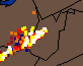 At right: WV lightning strike data at 1:30 AM. White squares show ground strikes occuring at that time, colored squares indicate earlier discharges.
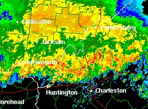 At left: Doppler radar image at 1:30 AM. This line was moving east-northeast (parallel to itself), meaning all the cells in the line were 'training' over the same locations over a two hour period.
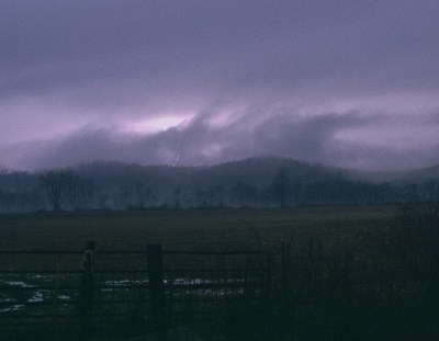 At right: Cloud-to-ground lightning strike behind the clouds about 3 miles away near Leon, West Virginia on January 24, 2002.


Web Site Design and Internet Marketing by CIS Internet