|
Home | Blog Index | Blog Archives | Christianity & Faith Essays | Storm Chasing Essays
Major cooldown/snow ahead, possible chase Wednesday
April is finally here, but the GFS (a computer forecast model) is showing a fairly strong signal of a significant cold Canadian air intrusion into the northeastern and Atlantic coast states by late next week. Snow even looks like a good possibility starting on Thursday! This GFS image shows the forecast temperatures for early Friday morning, bottoming out well below freezing for our entire region:
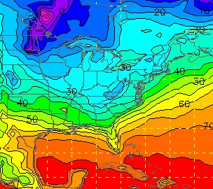
GFS temperature forecast for Friday morning
This image from the GFS shows the forecast precipitation type for Thursday night, showing a large swath of snow across the area:
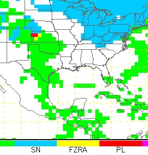
GFS precip type for Thursday night
On a side note, the models sometimes exaggerate temperature extremes in the long term. The GFS is especially known to do this from time to time, so the 'wintryness' above images may be slightly overdone. Nonetheless, a big cooldown seems like a good bet.
This pattern seems to be a fairly persistent one on the long-range models, meaning that the first week or two of April is likely going to be cooler than normal. This has several positive and negative implications. The bad news is our current prolonged warm spell has resulted in widespread trees and vegetation blooming and 'greening up', and the upcoming freezes will put a temporary halt to this. The better news is that from a storm chasing standpoint, right now is a very good time to see this type of pattern. It means that a change back to a severe weather pattern will likely occur toward the end of April, which is when we'll be ready for it. Better to have the cold, northwest flow pattern happening now rather than in late April or May.
Before the big cooldown arrives, one more severe weather episode appears a possibilty in western Kentucky and Ohio. Moisture and upper-level winds appear favorable for severe storms and possibly tornadoes on Wednesday, which we'll be keeping an eye on for a possible chase.
GO: Home | Storm Chase Logs | Photography | Extreme Weather Library | Stock Footage | Blog
Featured Weather Library Article:
|


