| Home | Blog Index | Blog Archives | Christianity & Faith Essays | Storm Chasing Essays
Thursday-Friday outbreak/chase still possible
Models continue to be consistent and in agreement on the large negatively-tilted upper level trough advertised to affect much of the country this week. This will be a very powerful system if it comes to pass as currently shown, and as it stands, Thursday, Friday and Saturday have the potential to see a major tornado (and/or severe thunderstorm) outbreak stretching from the Plains to the eastern seaboard. It looks like a certainty that the wind configuration throughout the layers of the atmosphere will be rather extreme for the necessary ingredient of 'shear' (change of wind speed/direction with height). The main unknowns at this point are the timing of the system and degree of instability. Moisture return is shown as being robust ahead of the trough, but cloud cover and rain could prevent any of this from destabilizing. Instability is needed to allow storm updrafts to grow tall enough to tap into the powerful upper winds in the trough's front side.
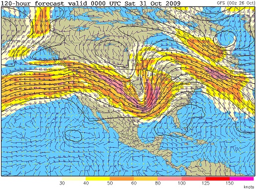
GFS 500mb pattern for Friday
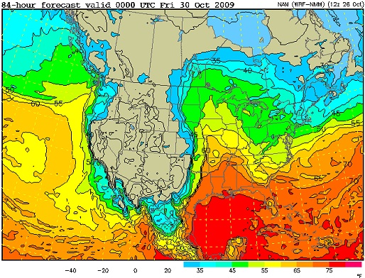
NAM dewpoints for Thursday
If significant clearing occurs ahead of this system on Thursday and Friday, allowing for greater instability to develop, the chances for a major tornado/severe storm outbreak will be high both days. The event could continue into Saturday across the Atlantic coastal areas from the Carolinas into New England. For me, this is looking like a definite chase-worthy event for at least one of the days. As I mentioned, timing is still hard to call - but the current model trends suggest an Indiana/Illinois/western Kentucky target on Friday afternoon/evening. That target will likely change several times as new model runs come out, but I expect I'll be on I-64 westbound on Friday morning nonetheless. Stay tuned for updates!
|


