| Home | Blog Index | Blog Archives | Christianity & Faith Essays | Storm Chasing Essays
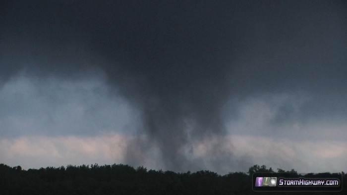
Weak tornado near Geff, Illinois - July 2
HD EXPEDITION VIDEO: Tornado near Geff, Illinois
Update: I was informed on July 25 that the National Weather Service office in Paducah, Kentucky will officially classify this as a tornado. Here are the details extracted from my GPS log:
Time: 23:55z to 23:56z, Tuesday, July 2, 2013
Viewed from: 38.4504033 -88.2945633, 5.6 miles due east of Geff (Jeffersonville)
Tornado was ~1 mile due east.
Day 2 of the Midwestern upper low-induced tornado environments brought this score near Geff, Illinois. Geff, also known on maps as Jeffersonville, is east of Mount Vernon, and north of Fairfield. The view is looking due east. This feature is moving north. Originally, I was only 70% sure that what I saw here was a tornado. If it wasn't, I really wasn't sure what to call it, as I'd never seen anything quite like it!
As with yesterday's tornado event, low clouds and fog were scattered underneath the storms. Both yesterday and today, in many places, columns of fog would extend all of the way to cloud base, leading to a whole host of tornado look-alikes that would probably fool most people unfamiliar with storm features (especially when viewed at a distance). For an experienced storm chaser, however, these 'fog-nadoes' are easily dismissed due to one key characteristic: lack of motion. The fog columns would drift lazily along, coming and going slowly.
Like yesterday, the key characteristic to look for with any suspicious lowered cloud formation was simple: is it rapidly moving upward/rotating or not? Rotation and rapid upward motion in a cloud feature isn't hard to see, especially when viewed within a mile or two. The tornadic features had very clear rapid upward motion and rotation that made identifying them easy. The ambient cloud bases surrounding the tornadoes also displayed easily-identifiable characteristics, like upward motion in cloud tags and rapid horizontal movement toward/around the center of circulation. The non-tornadic fog columns usually were located where the cloud bases displayed no notable motion.
I say all that to preface the description of the July 2 Geff, IL event. This feature actually began as a slowly-rising fog column that was visually non-tornadic. However, the rising motion in the column gradually increased to apparent borderline--minimal-tornadic speeds, followed by the gradual onset of rotation. I have witnessed this behavior with two other tornado events, both associated with cold upper lows:
- 7/1/13 Saint Francisville, Illinois tornado: This tornado started as multiple slowly-rising fog columns that gradually increased in vertical velocity while congealing into a single column. As the single rapidly-rising column became established, it developed rotation. The final result was a fully-established tornado with "normal" tornado motion and rotation by its mature stage. [ View the video of this event ]
- 5/20/10 Sedalia, Missouri tornado: The May 2010 Sedalia tornado began as slowly rising condensation fragments that gradualy increased in both velocity and density. The tornado did not exhibit rapid rotation until the later stages in its life cycle. [ View the video of this event ]
Originally, my best guess was to call the July 2 Geff, Illinois feature a "pre-tornadic pressure fall event", though it was actually a true (yet very weak) tornado. It is apparent that a incipiently-tornadic concentrated column of vertically-moving air was getting established, causing a pressure drop at the surface that resulted in the air parcels saturating and condensing. The difference between Geff, IL and the strongly tornadic events at Saint Francisville, IL and Sedalia, MO is that the Geff feature either 1.) did not endure long enough to allow the vortex to fully mature, or 2.) the updraft/inflow was not robust enough to allow the feature to reach sustained tornadic intensity.
Either way, it's an interesting feature that I'd love to hear commentary on.
NOTE: Chaser L.B. Laforce forwarded me a link to his video of a similar event he captured on July 27, 2011 that apparently made it into official Storm Data as an EF0 tornado.
Dan,
I was nearby, on the East side of these features looking west. I tried to stay just on the east of the center of the main surface low, and followed these features from around Benton at about 2PM until I was stopped by flooding roads Northeast of Fairfield around 6:30. Everything seemed to be loosing intensity by then as well, so I called it a day and went back home.
I'm glad you weren't sure what to call these either. I was close to reporting on a couple of these, but just wasn't sure how to report them. I decided they weren't likely strong enough to do real damage, and by the time I thought about reporting anyway they would dissipate, so I chose not to report.
When these features were at their strongest, I did note that it was during the periods of best inflow. The inflow was backed(almost directly SE), and weak(10 knots or less), but constant. The air temp my car was reporting during these periods was 71 to 74.
I plan to upload a youtube video later, and will post a report in the Target area thread you started on Stormtrack with the video link. You will be welcome to post a link to it here as well, if you feel it adds anything to your post.
- Posted by Scott Sims from Herrin | | |
Thanks Scott, glad someone else was there to see it! The updrafts weren't very robust this day, if they had been able to tap some of the better instability to the south, I believe we would have had a repeat of Monday. I sent everything to PAH to get their opinions, and so far they are leaning toward tornado. I also had to break off the chase due to the flooded roads - that was bad. At one point, without warning I crested a hill and the road ended in a giant lake. If it had been at night I would have probably driven into it.
- Posted by Dan R. from New Baden, IL | | |
|


