|
Home | Blog Index | Blog Archives | Christianity & Faith Essays | Storm Chasing Essays
Plains trip forecast update 5, for April 29
Just a quick update to comment on the system coming into focus for next week. Models are converging on chase-worthy setups on Tuesday (May 1) and Wednesday (May 2) in Nebraska, Kansas and/or Oklahoma, thanks to moisture being in place underneath a belt of southwesterly upper flow provided by a western US trough:
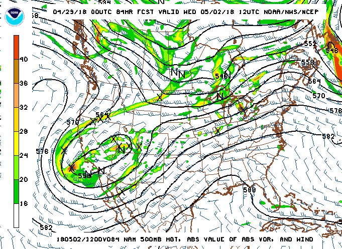
NAM 500mb pattern for May 2
It appears all of the ingredients for supercells and tornadoes will be present in reasonable quantities on both of these days, possibly extending into Thursday (May 3). Dewpoints in the mid 60s are shown making it to the Kansas/Nebraska border by midday Tuesday, and that moisture should remain in place before a cold front pushes it all back down toward the Gulf late Thursday or Friday. Upper-level support in the form of at least 30 knots of midlevel flow through the period will be sufficient for supercells, and a breakable cap will be present to hold off storms until later in the day. Monday's event (April 30) promises a few supercells, but with the deeper moisture not yet arriving until the next day, tornado potential will be limited.
While none of these days appear to be high-end outbreak setups by any means, they are enough to meet my criteria for a Plains storm chase expedition - and trip #1 for the season looks likely. Departure westbound from St. Louis is tentatively planned for Monday afternoon, and I'm on standby to leave Sunday afternoon if Monday's moisture situation improves dramatically.
The following table charts the probabilities for a Plains storm chase expedition taking place for the date ranges shown:
| 2018 Plains Storm Expeditions - Probabilities as of April 29 |
| April 29 | 30% | |
| April 30-May 2 | 75% | |
| May 4-9 | 2% | |
|
GO: Home | Storm Chase Logs | Photography | Extreme Weather Library | Stock Footage | Blog
Featured Weather Library Article:
|


