|
Home | Blog Index | Blog Archives | Christianity & Faith Essays | Storm Chasing Essays
Can we forecast how good or bad a storm chasing season will be?
As we close in on the month of April each year, the storm chasing community is always rife with speculation on how good or bad the upcoming peak season might be. Model forecasts - at best - only give us an idea out to roughly 10 days, so there has always been an interest in trying to discern any inkling of what we can expect a month or two out. Is there a drought in the central/high Plains, or has there been abundant precip? Are we in an El Niño or La Niña period? What does the latest CPC climate outlook predict for April-June? Those three predictors are the most commonly-cited as harbingers for the upcoming tornado season, but exactly how useful are they?
To attempt to find out, I gathered archives of drought maps, CPC outlooks, tornado reports and the Oceanic Niño Index for these two large infographics going back to 1980 that show how these have correlated with the quality of tornado seasons in the past. These images are best viewed in their full-size PNG forms (around 7MB each), the preview images here just give an overview of what is contained in them. The download links are as follows:
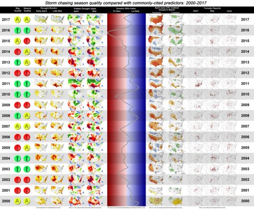
- Graphic A - 2000-2017 (PNG, 6.5MB): Graphic showing UNL Drought Monitor maps for early April and late May, Palmer Drought Index maps for April and May, April-June CPC temperature and precipitation climate outlook issued in mid-March, the full-period (continuous) Oceanic Niño Index plot (beginning of each year at the bottom of each row), SPC tornado reports for April, May and June, and my subjective opinion on whether a May and an entire storm season was above average, average or below average in quality.
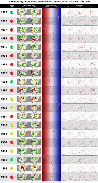
- Graphic B - 1980-1999 (PNG, 7MB): Graphic showing Palmer Drought Index maps for April and May, the full-period (continuous) Oceanic Niño Index plot (beginning of each year at the bottom of each row), SPC tornado reports for April, May and June, and my assessment based on Stormtrack magazine archives on whether each storm season was above average, average or below average in quality. (UNL Drought Monitor maps are unavailable prior to 2000, CPC outlooks are unavailable prior to 1995, hence their exclusion from this graphic)
Small previews of each graphic:
In short, I was not able to discern any of these factors as having any skill in predicting the quality of upcoming storm seasons. My feeling is that the idea that droughts equal bad seasons or "everything east of I-35" seasons are little more than urban legends in the storm chasing community that simply get repeated every year. There have been good and bad seasons in periods of drought and abundant precipitation, during strong and weak El Niños and La Niñas, and during both dry and wet-progged periods as outlooked by the CPC.
There is a good discussion on Stormtrack about this data that contains some important points for and against the conclusions I'm drawing here, I would highly recommend giving those a read.
My assessment of a storm season's quality, while it is subjective, I believe reflects what the majority of storm chasers would find reasonable. That is, taking into account the quantity of easily chaseable, photogenic storms and tornadoes on the dryline in the typical times and places that storm chasers spend their vacations. It's true that a single storm can "make a season" for an individual chaser, but I wouldn't classify a single good event as making for a good storm season overall. Take 2012 for example: while my April 14 chase made the season for me, the scarcity of good events apart from that day - particularly during May when most storm chasers were out - made it a bad one for a large fraction of the community. As a result, I must classify it as a below-average season overall, even though it wasn't for me.
Storm chasing forecast update for March 19: Now, we'll return to our regular look at what the next week and a half might hold in the realm of Great Plains and Midwest severe weather. The system currently making its way through the deep South brought the first tornado to the Plains in the Texas Panhandle on Sunday. Following this system, there isn't a whole lot to talk about. The reason for this is that the larger-scale jet stream has remained encamped in the southern US (as it commonly does this time of year), which has worked to keep moisture confined to the southern tier states. This has also meant that any small ripple in the flow that would trigger severe weather has had a harder time getting moisture much farther north than Interstate 40. Models don't show this overall trend breaking down any time soon.
There is one of those "ripples in the flow" (what's called a "shortwave trough" in meteorological terms) shown traversing the lower 1/3 of the country on Friday and Saturday, with some meager moisture shown making its way north into Kansas on Friday and possibly Missouri on Saturday. To me, this looks like little more than a "chase if it's in your backyard" type event, nothing worthy of a long drive.
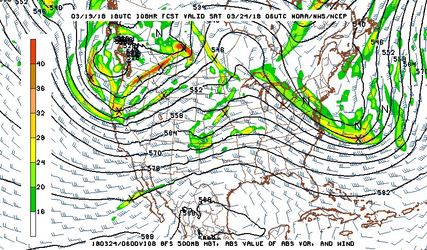
500mb pattern for March 23
Beyond that, I don't see any chase-worthy setups of interest showing up in the long ranges. It's that time of year, so we'll keep watching - the first one will likely get here soon enough.
The following table charts the probabilities for a Plains storm chase expedition taking place for the date ranges shown:
| 2018 Plains Storm Expeditions - Probabilities as of March 19 |
| March 20-22 | 0% | |
| March 23-24 | 2% | |
| March 25-27 | 1% | |
|
GO: Home | Storm Chase Logs | Photography | Extreme Weather Library | Stock Footage | Blog
Featured Weather Library Article:
|


