|
Home | Blog Index | Blog Archives | Christianity & Faith Essays | Storm Chasing Essays
Storm chasing forecast update 7 - for May 16
We're heading into the climatological peak of spring tornado season, but the atmosphere is having other ideas. After our late winter and cold April, we have yet to see a good upper-level wind pattern for severe storms and tornadoes in the Great Plains this season. The closest we got was the positively-tilted trough at the beginning of May which managed to produce a single significant tornado in Kansas, but little else. Other than that, the season has been relatively quiet so far - and models don't offer much hope that this trend won't continue. The main problem has been a "Hudson Bay vortex", a strong loop of upper-level winds in eastern Canada (shown on the chart below) that tends to block western US troughs from forming and/or prevent developed ones from moving east over the Great Plains. The result is only short bursts of weaker upper-level flow over the Plains, limiting storm organization.
Medium-term models show this pattern generally persisting through the heart of peak tornado season, with no end of the Hudson Bay troughing in sight. If this pattern continues, it could mean an end to the classic spring tornado season before it really begins. The upper-level ridging and low-level warming of the southwestern US and Plains that happens during this type of pattern can hasten the permanent season-ending migration of the jet stream into Canada. This migration always happens at some point, typically in early to mid June. While it's too early to say that we won't see a tornado-favorable deep west coast troughing pattern, time is running out for something to show up in mid-to-long-range models before the season ends.
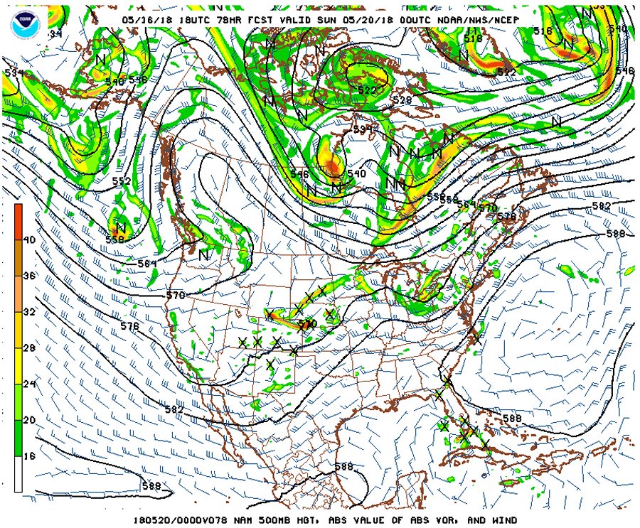
NAM 500mb pattern for May 18
In the short term, despite the Hudson Bay/eastern Canada trough, we do have some weak ripples in the upper-level flow (all shown above) overtop of instability that will provide just enough support for supercells and possibly tornadoes in the Great Plains from Friday-Sunday. However, unlike a large well-organized western troughing pattern, these smaller waves are very hard to forecast much in advance, and it is very easy for something to go wrong with the setups. An upper-level or surface feature shown by the models now being off by 6 hours or 50 miles in the end could make or break the potential. I am holding out some hope that Friday in Kansas may offer something worthy of a short Plains trip #2 (and likely only a one-day trip at that), but it is simply too early to make that call.
The following table charts the probabilities for a Plains storm chase expedition taking place for the date ranges shown:
| 2018 Plains Storm Expeditions - Probabilities as of May 16 |
| May 17-20 | 25% | |
| May 21-26 | 5% | |
| May 27-June 3 | 15% | |
|
GO: Home | Storm Chase Logs | Photography | Extreme Weather Library | Stock Footage | Blog
Featured Weather Library Article:
|


