|
Home | Blog Index | Blog Archives | Christianity & Faith Essays | Storm Chasing Essays
Storm chasing forecast update 14, for May 31
Models have been struggling with the upcoming pattern, illustrating why we often can't rely on them beyond 4-5 days during active periods. Case in point: here was the 500mb pattern forecast for Wednesday evening, June 4 by the 00z GFS model on Tuesday:
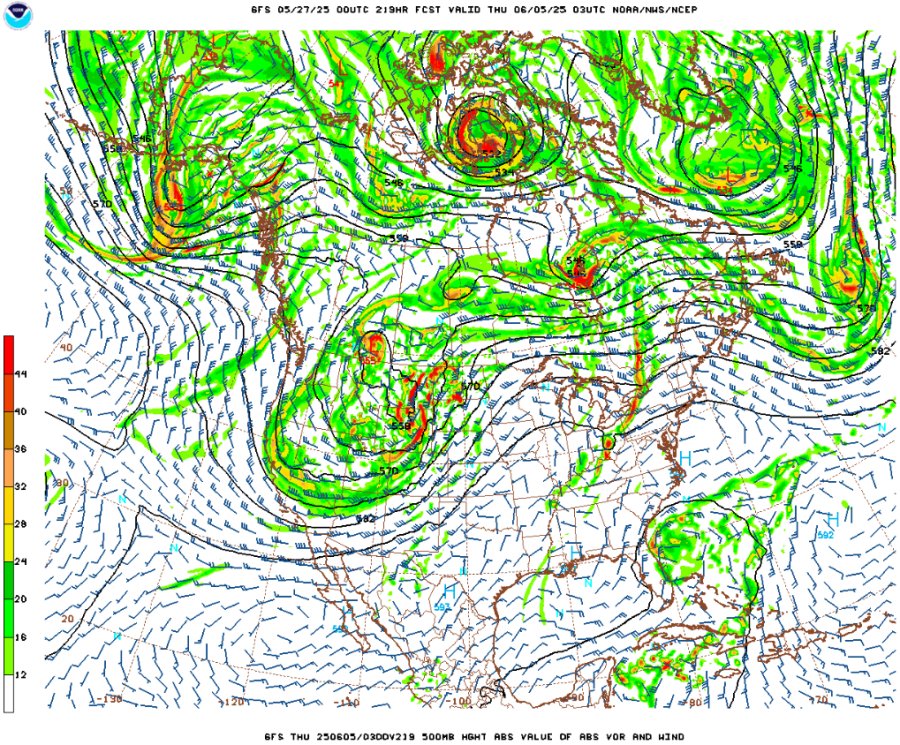
00z May 27 GFS 500mb forecast for Wednesday evening, June 4
And here is the latest (06z May 31) forecast for the same time:
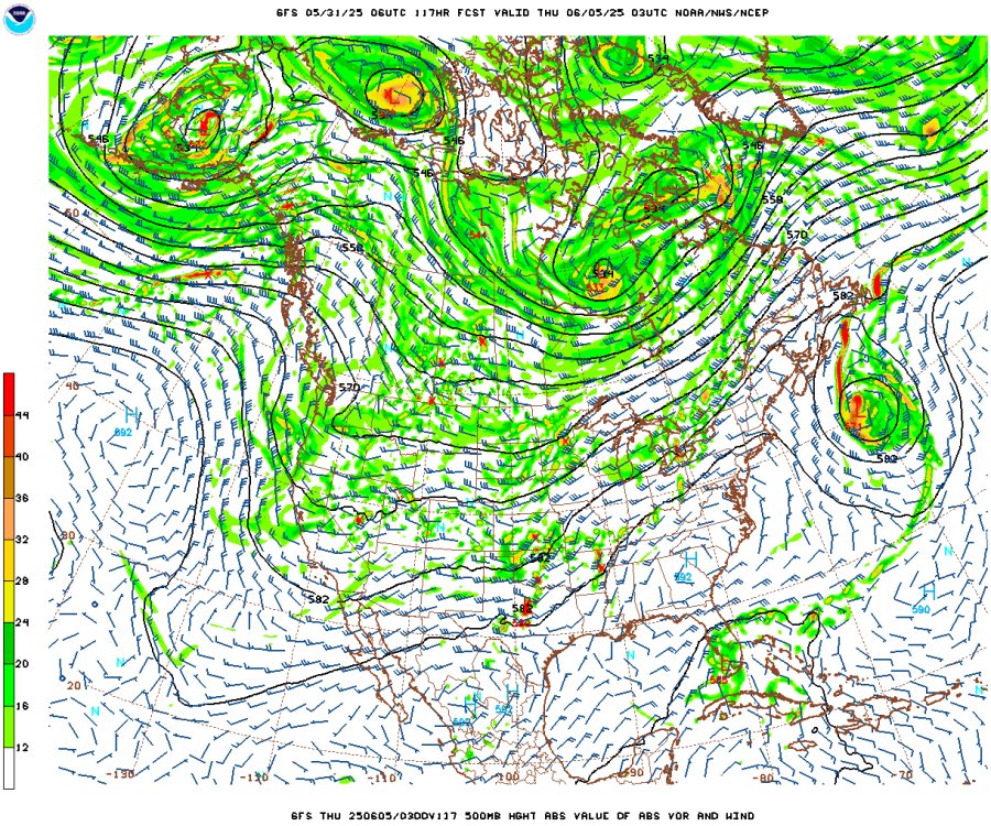
06z May 31 GFS 500mb forecast for Wednesday evening, June 4
That's a massive change with night-and-day implications for storm chasing in the Plains. The May 27 chart depicted a deep western trough dominating the US weather pattern, which would have promoted strong moisture return into the central and southern Great Plains. Now, the models show no big trough, but rather a low-amplitude general western troughing regime, with weaker flow across the Plains and Midwest. It's by no means a dead pattern, just not one that favors big, predictable severe weather episodes. Instead, we're looking at spatially-smaller and harder-to-pinpoint supercell and tornado events mainly in the southern Great Plains and Midwest through the end of the week.
The day of biggest interest in the near-term is Tuesday the 3rd as a shortwave ejects out over the central Plains, with potential action in eastern Kansas/Oklahoma through the Midwest. It's not a blockbuster setup, but it's closer to home than a typical Plains setup. That's the one day I have prior obligations here at home that morning - I won't be able to leave until after noon, limiting my target options. I may be able to make it to eastern Kansas if storms hold off until 5 or 6pm - but some potential also exists for supercells here on that day, which I would favor. For that reason, there is a 50-50 chance for a same-day Plains trip to take place on Tuesday.
Beyond that, the models are in too much disarray to say much of anything about what follows. They have been all over the place with the potential pattern for late week and after, even showing a possible tropical cyclone in the Gulf by early next week. The overall trend considering the GFS, Euro and the ensembles is not great for chasing in the Plains, but not completely dead either. At this point, my long-term optimism for a Plains trip during that time is low. We'll see if the models can settle down on something by the end of the week. For now, Tuesday is the only big event of interest for me as far as Plains chasing is concerned.
The following table charts the probabilities for a Plains storm chase expedition taking place for the date ranges shown:
| 2025 Plains Chase Expeditions - Probabilities as of May 31 |
| May 31-June 2 | 0% | |
| June 3 | 50% | |
| June 4-10 | 35% | |
|
GO: Home | Storm Chase Logs | Photography | Extreme Weather Library | Stock Footage | Blog
Featured Weather Library Article:
|


