|
Home | Blog Index | Blog Archives | Christianity & Faith Essays | Storm Chasing Essays
March-April 2026 Storm Chasing Recap
March and April of 2026 were very active months for storms in the Midwest. Despite my limitations for chasing out of the area, I was able to observe and capture several memorable events. Four tornadoes were observed on March 10. The season's first Plains trip was a one-day outing on April 26. Lightning was the highlight of this period, with several good high-speed and dashcam captures.
March-April 2026 Event List
 March 4: Southern Illinois tornado bust March 4: Southern Illinois tornado bust
I went to bed Tuesday night not planning to do anything with the weather on Wednesday. The all-day messy thunderstorms in fog and low clouds would likely not offer much worth shooting, so I figured I'd just go outside at home or work to watch any of them that passed nearby. When I awoke at 1PM, a few storms to the southwest were heading into what looked like a not-too-shabby environment along a warm front positioned roughly from Sparta to Pinckneyville. The sun had been poking through down there, and the surface winds were backed nicely along and just north of the boundary. I thought it looked worthy of going a county or so to the south to see what this might do, so I headed down through Venedy to Coulterville to get ahead of the first potential supercell. Alas, a strong outflow was already racing ahead of the storm here, with a few new cells just south of Pinckneyville looking to possibly take over southeast of the outflow.
When I finally got in position on these new storms at Benton, I found the outflow was already 5 miles ahead of them. The only other play was isolated cells to the southeast heading for a river crossing into Kentucky. I'd need to drive almost 2 hours to get into position on these via Harrisburg and the Ohio River bridge at Shawneetown, and it didn't look like I'd make it in time. After a few radar scans of these cells still struggling, it was apparent that effort would not be worth it. I hadn't even planned to drive this far today as it was. I turned around and headed back home to seal the bust, after seeing a few distant lightning strikes but nothing of any photogenic value. No cameras touched this day.
Later that night, continuous thunderstorms traversed the St. Louis metro area for several hours - but all of it was obscured by dense fog. The Arch webcams showed this fog layer was very shallow, maybe 200 feet high, with the tops of taller buildings downtown (and the Arch itself) in clear air above it. I went out once near Shiloh during my lunch break at 8:30PM in the hopes that a stronger cell passing overhead would produce enough wind to mix out the paper-thin fog layer, but that didn't happen. March 5: New Baden, IL lightning bust
As distant thunder continued to roll as it had been doing all day on Wednesday, I walked outside at 2AM to take another look at the conditions. The thick fog from earlier was gone, and I could actually see lightning in a storm to the distant south. The stratiform precip of thunderstorms 70 miles to the south was overhead and producing a flash or two every 5 minutes or so, so I took the high speed camera down the road to my typical viewing spot for about an hour. No lightning channels exited the clouds. After the storm moved east of due south, I was done with it - I'd have to start facing the wind-blown rain to keep shooting.
 March 6: Storms from Bowling Green, MO to Springfield, IL March 6: Storms from Bowling Green, MO to Springfield, IL
As the expected two-day severe weather episode on Thursday and Friday (March 5 and 6) neared, I became less enthusiastic about both of them for chase prospects. The main shortwave trough ejection on Friday was shown as the bigger event, with a tornado risk from Texas to Iowa, centered on eastern Kansas and Western Missouri. Thursday's event showed some potential, too.
By Wednesday evening, models mostly agreed that the zone of Thursday's target would be from Amarillo to Oklahoma City. This "day before the day" setup appeared quite nice on paper, with everything needed for supercell tornadoes. The main caveat was that most models didn't fire storms until after sunset. A likely nighttime event with a 12-hour drive (one way) was off the table for me, so I just focused on Friday.
As Friday's "main event" neared, it too was losing a lot of its earlier luster in model depictions. The "shortwave" for this event (a smaller wave embedded in the larger jet pattern) was shown by all but one model to be in a configuration that favored an early squall line (see Stormtrack's event thread for this day for the details on that). Furthermore, the broad warm sector and wide belt of fast upper level flow meant a tornado risk would also be present across a vast area in nearly the entire Midwest region, even up into Michigan. Models suggested supercells could form from Columbia to Hannibal, mostly west of St. Louis - but within a 2-hour drive.
In the 24 hours before this event, model depictions were hodgepodge and not in good agreement of where the best areas would be. The morning didn't bring any clarity to that picture. What I did see was that the day appeared on course to be messy and likely not worth driving more than a couple of hours for. By noon I was committed to staying in my "home area" (for me, that's roughly a 2.5 hour's drive radius). I headed to my starting target of Foristell, Missouri.
As the afternoon wore on, visible satellite revealed many cumulus fields across Missouri and Illinois that could eventually become thunderstorms. It was a roll of the dice of where to go, until I noticed the surface winds in central Missouri veering to the southwest, while winds along the Mississippi River and Illinois were still southerly and even slightly backed to the southeast. This indicated an area of low-level convergence had developed roughly from Foristell through around Jacksonville, Illinois, and this area would likely be where storms would develop. I headed up to Bowling Green, MO as storms began firing all around the convergence zone.
I moved across the river up to Pittsfield as this activity struggled to take off. A few of the cells managed some lightning strikes, but not much else. The updrafts were high-based and the storms quickly became outflow dominant. A gust front eventually developed and pushed far to the southeast, ending the tornado threat in this entire cluster.
With the chase mostly over, I stopped in Jacksonville for dinner. Back on the road, I stayed with a few new cells that had formed behind the gust front along I-72 southwest of Springfield, hoping for a few lightning strikes while the setting sun peeked through the rain shafts to the west near New Berlin. This is the only time I picked up a camera during the chase:
The lightning didn't happen. All of these cells slowly faded along with the daylight, so I was home by 7:30pm.
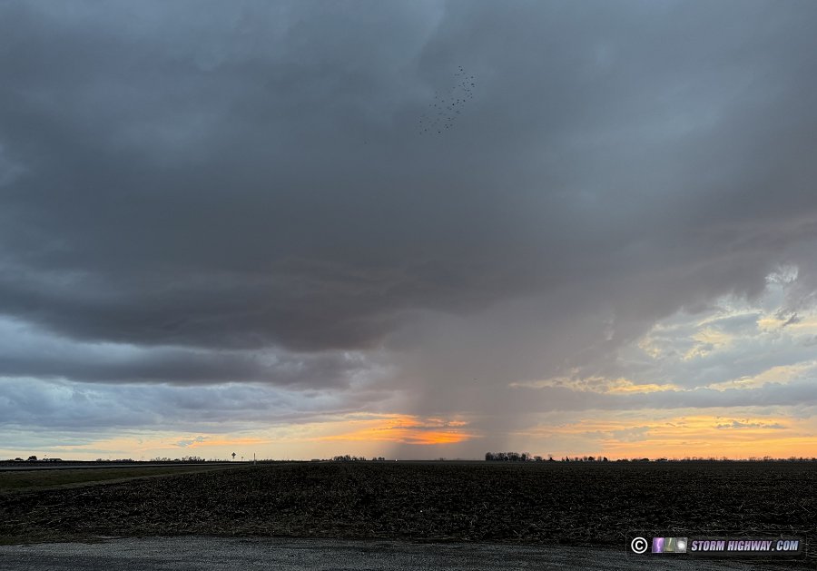
 March 10: Tornadoes at Kankakee & Pontiac, Illinois, northwestern Indiana March 10: Tornadoes at Kankakee & Pontiac, Illinois, northwestern Indiana
A wild chase day just south of Chicagoland in northeastern Illinois and northwestern Indiana. This event has its own page here with more photos and a detailed log.
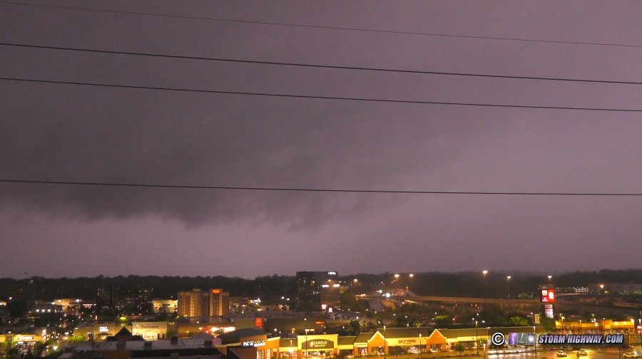
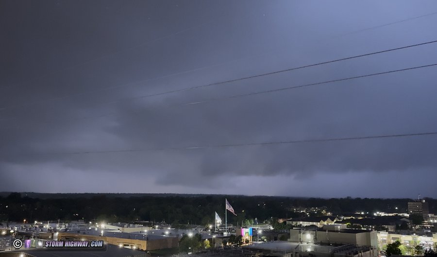
 March 15: Tornado-warned severe squall line in St. Louis March 15: Tornado-warned severe squall line in St. Louis
I had low expectations for this event, so I didn't do much other than watch the line come into downtown St. Louis, then stayed just ahead of it a short distance to the east of home. The main limiting factor for this event was paltry instability thanks to all-day cloud cover. The primary subject then was mesovortex tornadoes spinning up on the leading edge of a severe squall line, should any of the line's updrafts manage to nose out ahead of the plowing cold front. Radar showed that these circulations were plentiful, each triggering constant tornado warnings through and beyond the metro area. While some of these displayed classic features like RFD clear slots, motion at cloud base was very weak. I also did not see a single power flash from my aerial vantage point as this line moved across the dense urban core of the city.
The best-looking meso/clear slot, looking northwest toward the airport:
Video (timelapse and realtime):
As I wrapped up video editing at home, evidence of the strength of the cold advection behind the front was plentiful. At 8:30pm, snow was already being reported in St. Charles county on the west side of the metro area, Kansas City had icy bridges and pings of sleet could be heard on my window. That's only 2 hours after I'd been in a warm-sector thunderstorm with temperatures at 70°F. That's the fastest such transition I've experienced in my chasing career.
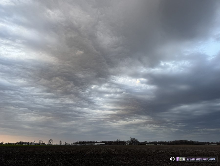
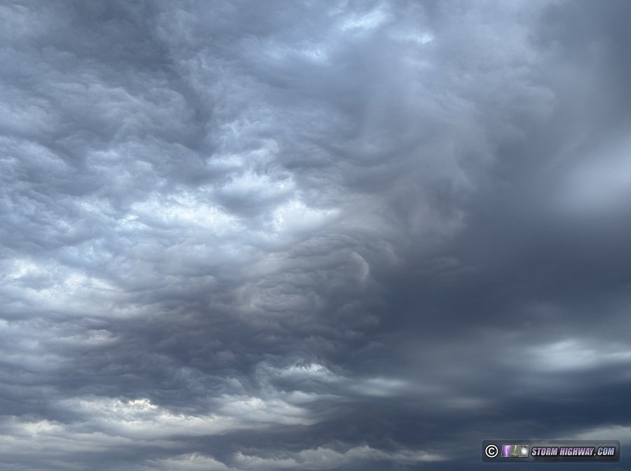
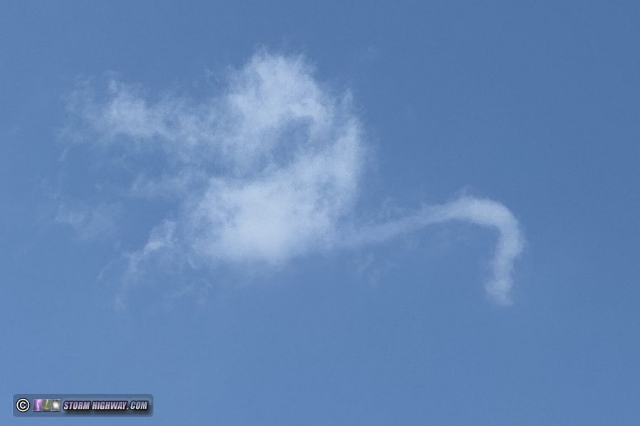
  March 22: Cold front and asperatus clouds March 22: Cold front and asperatus clouds
Storms were expected to fire along and behind a strong cold front pushing through the Midwest this day, but mostly to the northeast of our area. I went out to shoot a timelapse of the dry frontal passage over the Prairie State power plant (as I'd done with a similar front back in 2012), but the front was moving much faster than I'd expected, and arrived before I could get set up. This sequence from my dsahcams is what I was intending to capture on the better camera, the wind shift arriving at the smokestack's plume:
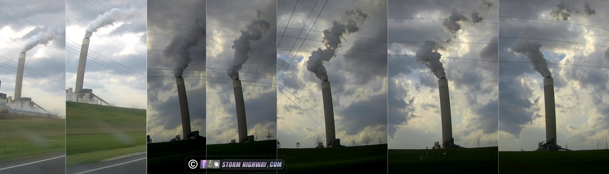
The northerly winds behind the front were quite potent, kicking up dust from the fields and even breaking some large tree branches.
A couple hours later, some post-frontal asperatus clouds moved overhead at sunset just before some weak convection managed to fire just east of town. Data showed a couple of lightning strikes to our east after darkness fell, but I didn't see them.
March 26: Cold front over New Baden, IL
Another strong, but dry, cold frontal passage in the St. Louis metro. About an hour before this arrived, a severe storm up at Taylorville was flashing to the distant north. There were no visible channels exiting the clouds.
I went just outside of town to watch (and feel) the front roll through. There was a nice arcus on the leading edge, and an interesting wind shift sequence (south-southwest to west, then suddenly north). Dirt from the fields kicked up enough that it would have been a more dramatic visual had it been daytime. This was moving fast enough that the cloud features were soft on the longer exposures.

March 31: St. Louis storm bust
I took a short trip into downtown St. Louis to await the possibility of storms developing on an outflow boundary in the city. Storms had fired west of the metro area, but all of them ended up passing well to the north. This activity had low lightning flash rates and wasn't worth the drive to Litchfield that would have been required to intercept. Some weak convection started percolating on the boundary east of downtown near sunset, but never could get established.
April 1: Perryville, Missouri storm bust
I decided the Plains setup this day was not worth the one-day trip to be there for it. Furthermore, a stationary/warm frontal boundary was draped across southern Illinois and Missouri, roughly from Fredricktown, MO to near Vienna, Illinois. Models indicated some storms might develop near or on this boundary during the afternoon and possibly track along it.
At 1PM, after the boundary had been in partial sunlight for a couple of hours, a storm fired west of Ironton right on the front and quickly developed a midlevel meso apparent on radar. It appeared to be already on the boundary and on the verge of latching on. This storm, if it managed to maintain intensity and stay on the boundary, would likely produce tornadoes as it tracked to near Perryville. I headed down there to intercept it, but the storm moved north of the front and completely dissipated before I arrived.
Another storm to the southeast near Cape Girardeau looked like it was starting to take off, but it was already north of the front:
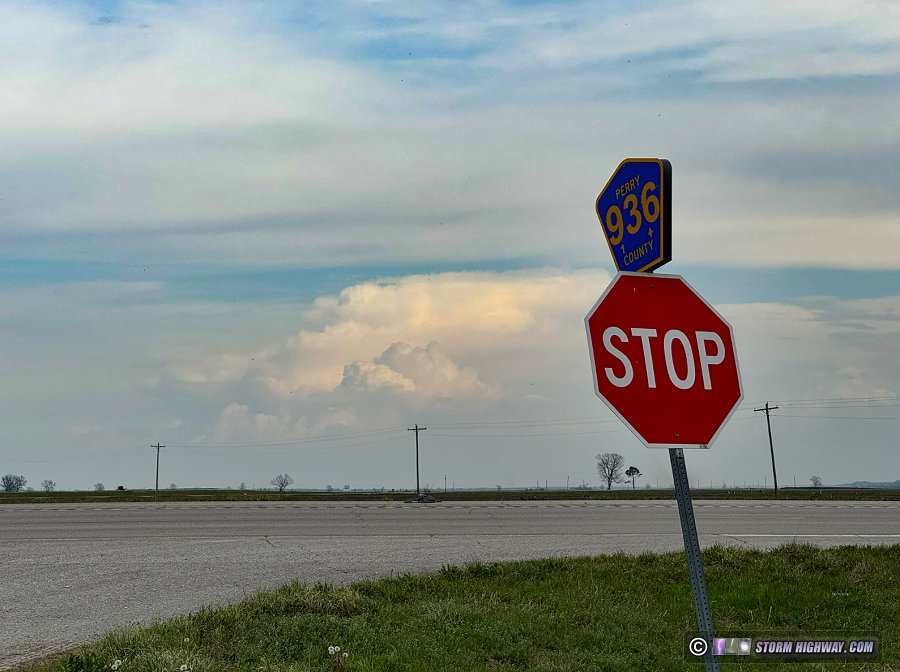
All convection within a 3-hour drive completely died off by 5PM, ending any further chase opportunities within range before dark.
April 2: St. Louis metro storm bust
As is typical for the vast majority of Midwest setups, the main chase target for this event was where storms in the northeast quadrant of the surface low arc interacted with the warm front. This would be all the way up in Iowa, and I just didn't feel like this setup was worth that kind of a drive. Again, thanks to the copyright infringement problem and the current spike in gas prices, I'm going to be much more limited on chasing distances this year and have to be judicious to make sure I have the ability to travel out of the area for the truly big days. Furthermore, models had indicated some decent tornado potential close to St. Louis, making it a no-brainer to stick to my current modus operandi of staying local.
In the St. Louis metro, there were two rounds of storms that offered tornado potential. The first was early afternoon storms that was expected to evolve out of the remnant precip from the overnight hours, but this would be on the eastern edge of the instability axis and at risk of running out of the surface-based CAPE. The second and more appealing prospect was storms ahead of the cold front shown peaking between 5 and 7pm in the northern/western metro area. These would have access to greater instability and have much better low-level shear. I decided I'd just take a quick look at the early activity, then bail west for the second round.
The early activity began after 3pm, with a cell rapidly developing and passing over downtown St. Louis. It was disorganized with no structure nor meso apparent on radar. Some early signs of mesocyclones were apparent at the southern end of this line of activity down near Cape Girardeau, heading toward the Mount Vernon area to the east. However, intercepting this would put me out of play for the evening round in the western metro (particularly with rush hour traffic to go back through). I chose to forego the eastern storms and head to St. Charles to make sure I was past the traffic and in a good position for the evening round.
The western storms began firing right on schedule at 5pm, but when I got my first look at them from Wentzville, the updrafts were skinny, high-based and struggling:
These were also rocketing away to the north-northeast, and given their appearance were obviously not worth a valiant effort to stay with them.
The issue now was that further storms would be developing and intensifying very close to, if not right over, the no-man's-land of the Mississippi/Illinois Rivers confluence zone. This area has few roads, no bridges across the rivers (only ferries) and is heavily forested. If you intercept a northeast-moving storm in St. Charles County, you'll lose it in short order to the confluence zone and have a lengthy, circuitous route via Highway 67 through Alton to re-intercept in Illinois. With storm speeds this day, that route would be non-viable. Usually in these cases, it's better to wait on the Illinois side where roads and terrain are better. The complication being that today, there was a risk for these storms to turn right as they went supercellular. If that happened, they could end up tracking along or even south of I-70 for an extended period, which would not be good for you if you're trying to scramble back there from Illinois.
The solution to this dilemma was to position at St. Louis Mills in Hazelwood. If storms went supercellular quickly, I'd head west back into St. Charles County. If not, I'd move east and north to Godfrey, Illinois. I had to make this shuffle twice as multiple storms died and re-developed southwest of Wentzville. Eventually, as the last storm showed no sign of turning before crossing the rivers, I made a final move up to near Jerseyville to await them there.
Despite convection finally beginning to solidify all along the front after sunset, no mesos were apparent and lightning was weak and all inside of the clouds. After watching this for 30 minutes, I decided I was done with the day. I made it home at 10pm.   April 3: Incredible supercell and close lightning in central llinois April 3: Incredible supercell and close lightning in central llinois
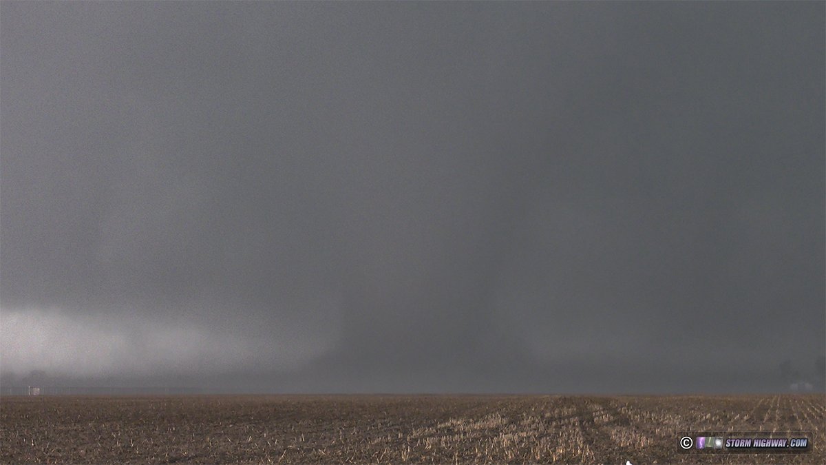
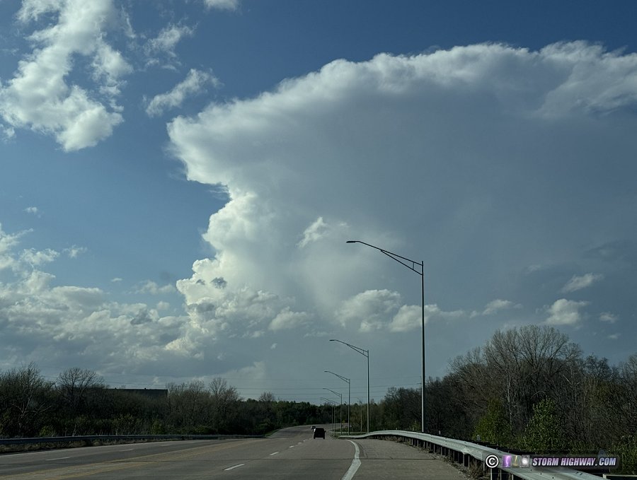
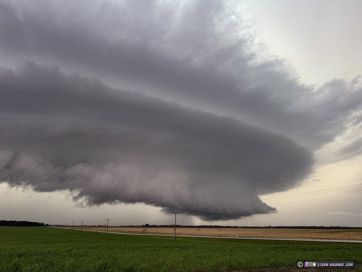
Yet another warm front tornado setup ended up producing the most amazing storm structure I've seen in the Midwest (after living here for 16 years), as well as an absolute lightning bonanza: two of the best close lightning captures in many years, and best of all, the capture of the lightning attachment process at 6,000fps!
Chase log: This day's tornado risk would be focused roughly from Quincy to Lincoln, IL as storms interacted with the boundary draped across northern Missouri and central Illinois. I headed up to Palmyra, MO as my starting point, grabbing a coffee in town before storms began developing to the west and south. When the eastern storms looked like they would be the main plays for the day, I chose to go back to Hannibal to cross the river rather than dealing with the long traffic-light plagued transit through Quincy.
Storms were slow to get going along the warm front. I parked near Camp Point to watch and wait. The more isolated storm near Havana to the east appeared to be a good play, but I felt my area would have similar potential. Finally, storms started taking off to my south and moving my way. But when I got my first visual on them, they appeared to be left-moving with their primary updrafts on the north side of the cores. I've rarely seen storms recover from their main updrafts being on the wrong side, but I decided to stay with it for a while to see what it would do. I didn't have anything else within range.
As I moved north then east to stay with this, a barrage of negative lightning began. One bolt struck a high-voltage power line a few hundred feet in front of me, producing a flashover on the adjacent low-voltage lines on the other side of the road (watch video):
I let the cores overtake me to see if there was any updraft managing to take shape in the right location. There *sort* of was, but it was disorganized and showing no sign of developing further, despite being in the frontal zone. Stronger convection was developing to the south, fouling this storm's inflow. That spelled a long-term pause in tornado potential in this area. Meanwhile the Havana storm, about an hour to the east, was tornado warned and looked poised to start producing. With my storms looking like long-term garbage, I didn't see any other option but to blast east to the Havana storm. I wouldn't be able to catch it until beyond I-39.
After I passed through Havana, I noted that the original tornado-warned storm seemed to be having trouble keeping a meso organized with each cycle, and apparently hadn't become the tornado machine it had seemed on course to be. Meanwhile, the storms to my southwest that I'd left behind were beginning to coalesce around a dominant cell that just had the "look" like it was getting ready to do something. The cell to its immediate south dissipated, and the entire mass began assuming what looked like a supercell transition. And the warm frontal zone was just ahead of it. With every storm chaser in the Midwest heading for the main supercell to the east, I was compelled to give the western storm a chance to do something without the crowds all around it.
I parked southeast of Havana to watch this storm approach. Initially, it looked awful with a long, outflowy arcus along its entire base:

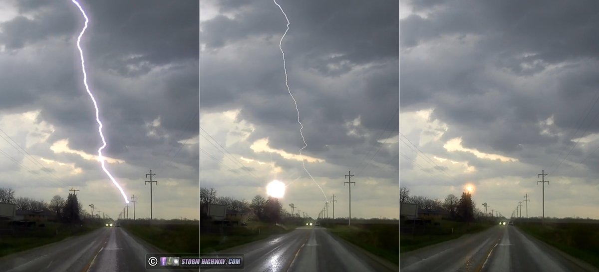
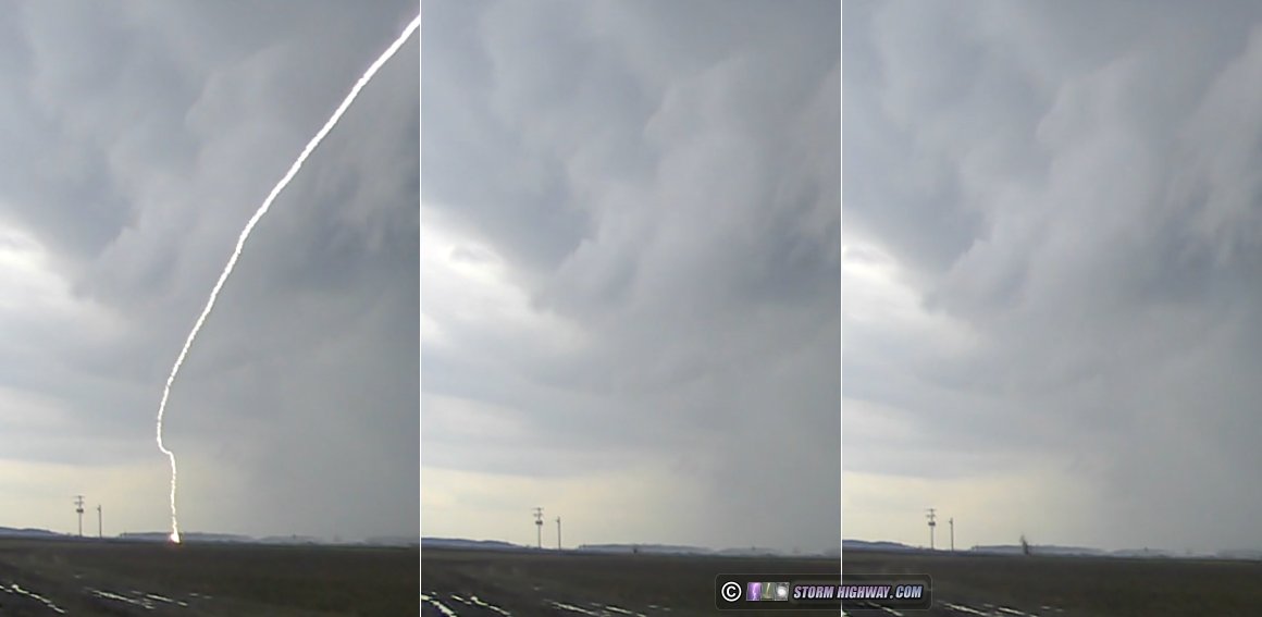
But there were hints that this was changing. Differential motion was becoming pronounced just behind the arcus' leading edge. Northerly/westerly outflow was pushing down low, but the southerly inflow was fighting back just above it. Structure began to improve, and a barrage of lightning began. I captured a few good 6,000fps high speed shots of these bolts here ( watch video).
What will likely be the highlight of my year is the capture of the lightning attachment process with this strike to the smokestack in the distance! Lightning "attachment" is the upward positive leader meeting the downward negative stepped leader to complete the strike. It's been something I've wanted to get at 6,000fps ever since I've been shooting with the high speed camera (watch video):
Kinks began appearing in the arcus as structure and lightning continued to intensify. I moved east to stay ahead. Each time I stopped to look back, the structure just got better and better. The storm appeared to be trying to wrap up on the north side of the outflow surge, transitioning quickly to a supercell structure:
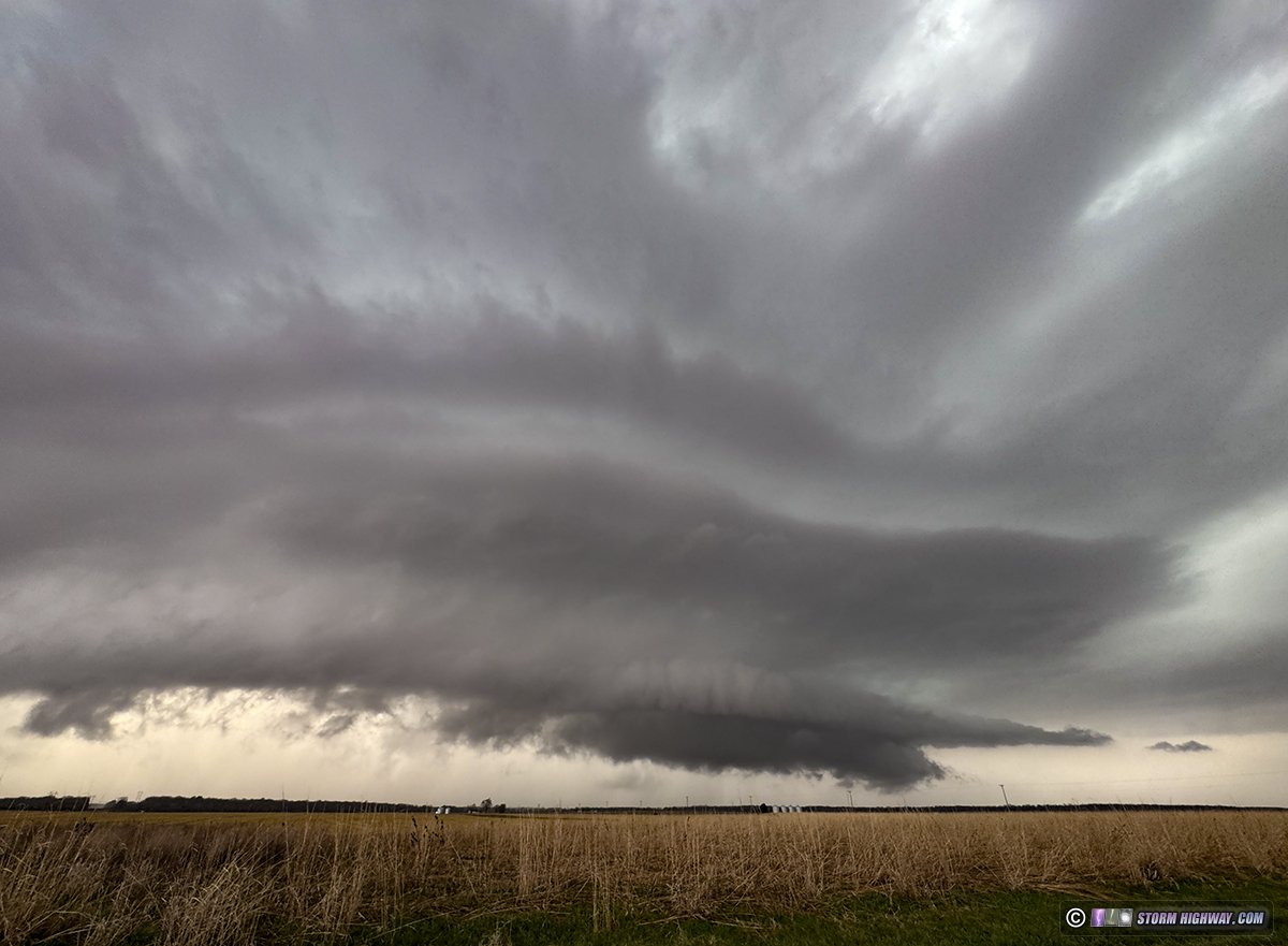
A strong circulation developed and looked to be seconds from producing. The tornado warning sounded as a barrage of intense, sonic-booming positive CG lightning began.

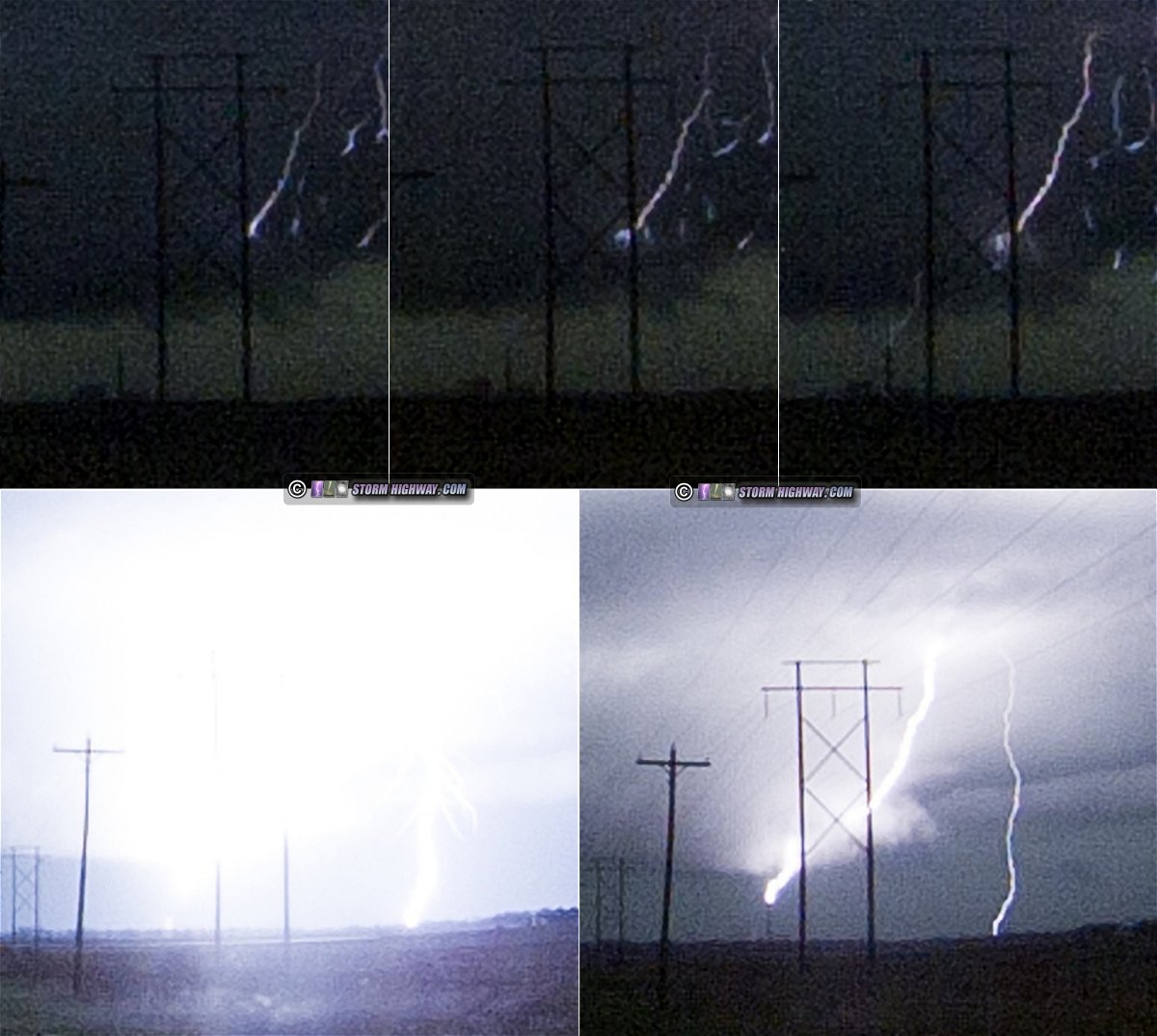
As I got the main video camera on this feature, a positive CG struck within a half of a mile. The thunder blast shook the car to the point that my dashcam's impact sensors tripped! When I pulled the video of this off of the dashcam, I was in disbelief to discover that the bolt had produced an explosion of dirt that shot about 20 feet into the air ( watch video):
This did not appear to produce a tornado here. With the storm now on my heels, I had to move east again to keep ahead. Radar VILs showed a dense, mean-looking wind-blown hail core was not far away, and I didn't want to chance getting caught by it.
I stopped briefly every couple of miles to grab a shot. I didn't notice this at the time, but a possible funnel was present in the right place for a tornado to be:
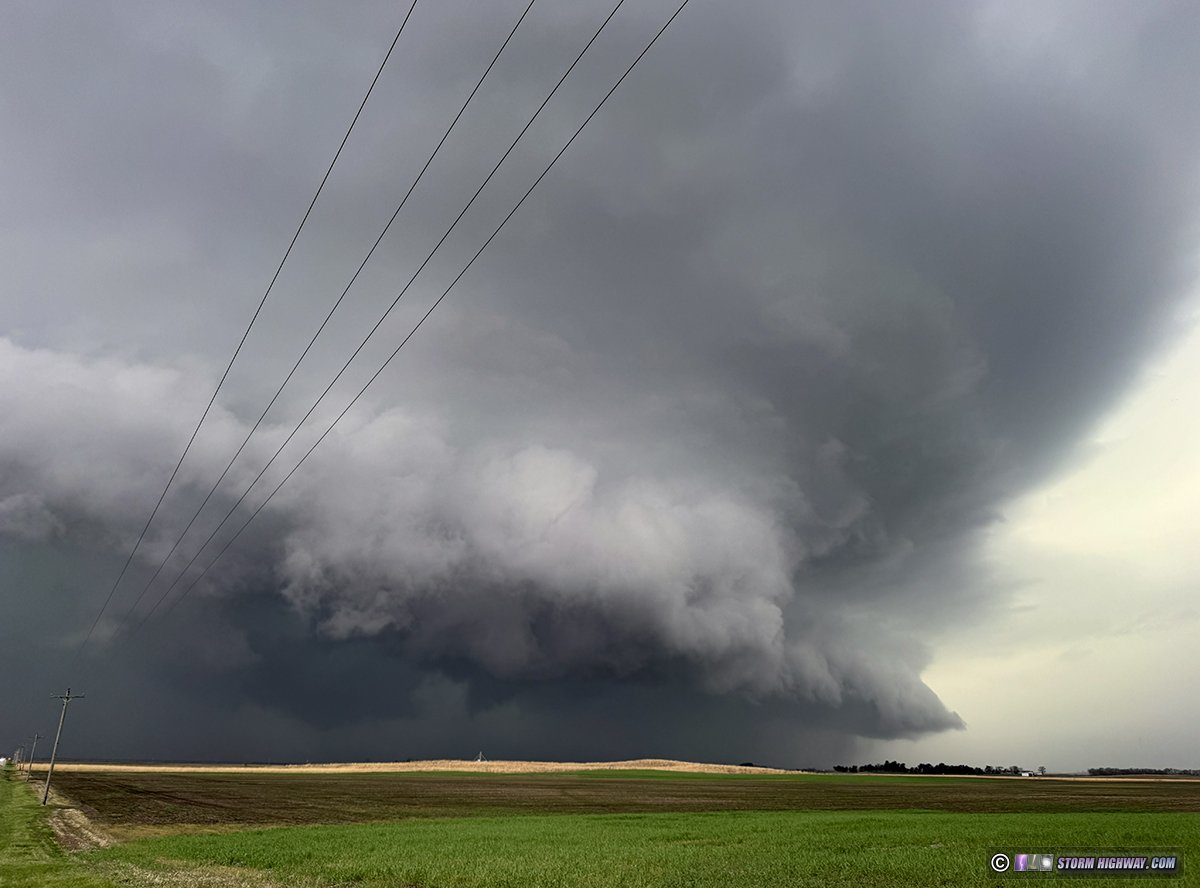
Structure remained top-tier:

As I moved north and east through Delavan, the storm slowly weakened. By the time I reached I-39, all indications pointed to it being done: diminishing lightning, VILs and velocities on radar fading and lazy scud gradually replacing the spectacular structure. The eastern supercell had also become disorganized, and I decided nothing warranted staying or pursuing further. I turned south on I-39 and made it home just after 9pm.
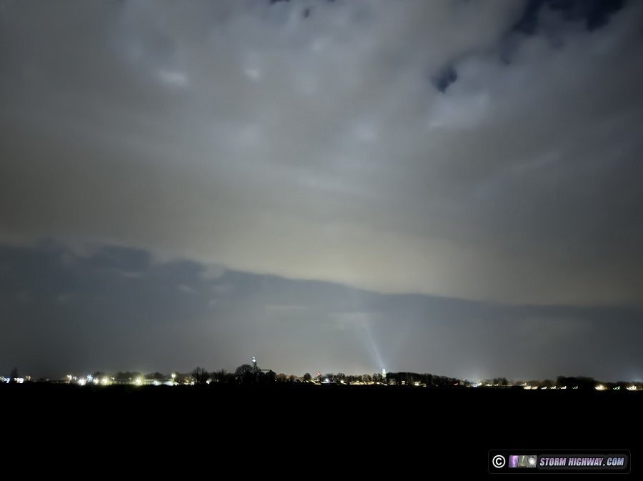
April 13: New Baden, Illinois sprites bust
The tornadic supercells in eastern Kansas transitioned into a single quasi-linear MCS (meso-convective complex) as they moved down the I-70 corridor in Missouri, eventually developing a stratiform region that promised some sprite activity. As is typical for most Midwest MCSs, this one sent its anvil cirrus canopy 200 miles ahead of it, blocking the view of any sprites from the St. Louis region.
Before midnight, this anvil canopy had drifted north enough that the tops of sprites might be visible. But viewed from here at home, this area would be directly over the city of St. Louis' light pollution. The only option to get that out of the way would be to drive an hour south, which I didn't think was going to be worth it. The storms were weakening anyway.
I set up just outside of town to do a 10-minute burst of 1-second exposures with the camera aimed above the cirrus deck, but I didn't see any sprites or even distant lightning flashes. April 14: New Berlin, Illinois horseshoe funnel during cap bust
I wasn't feeling the 7-hour drive (each way) needed to chase this day's primary tornado risk area in northeastern Iowa. Furthermore, during the previous 36 hours, models had been suggesting supercells within my "home area" (roughly 2.5 hours' radius) along the I-72 corridor. This continued into the morning after satellite revealed a decently-oriented outflow boundary from overnight storms just south of I-72. A strong cap would be difficult to overcome, but the models' consistency of firing storms was enough to make the 90-minute jump up I-55 to see what might happen.
Before crossing the boundary on the way north, these altocumulus virga (jellyfish clouds) were west of Hamel:
Models were somewhat consistent on a storm tracking along the remnant outflow boundary in the general vicinity of I-72 somewhere between Quincy and Decatur, and satellite showed several areas of cumulus in this region. It wasn't clear though which ones would be the incipient storms, so I headed to New Berlin (just west of Srpingfield) to sit and watch things evolve.
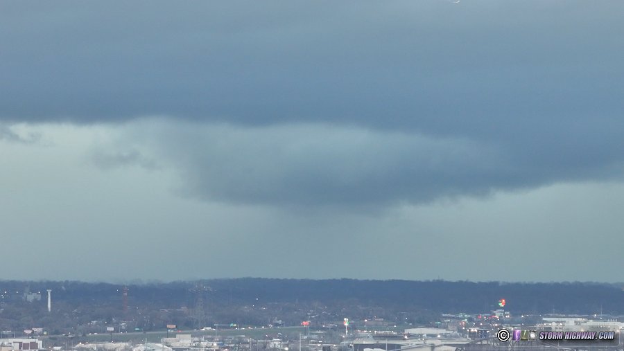
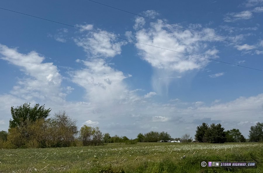
In person, the cumulus clouds were very flat and weren't showing any signs of agitation. Some brief hints of vertical development happened a few times along the Mississippi River to the west, and over Springfield to the east where rows of cloud streets were taking shape. These never progressed further. During this time, a horseshoe funnel appeared nearly overhead:
As the afternoon wore on, the cumulus fields began drying up. I held out for another hour as high-level cirrus was beginning to stream overhead, hoping this apparent arrival of faster upper-level flow might give things the necessary push to get a storm going. The tallest cumulus I'd see all day happened at Glenarm around 6pm, but it only lasted a few minutes before shriveling and sealing the "cap bust". I was home by 7:30pm.
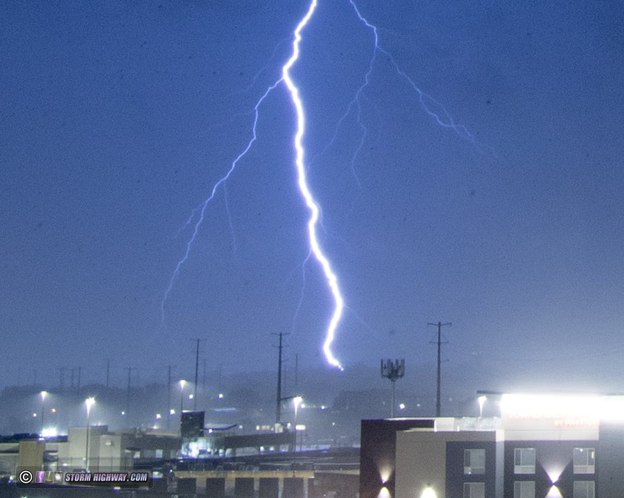
 April 15: Lightning from tornado-warned storm in St. Louis April 15: Lightning from tornado-warned storm in St. Louis
The prospects for storms this day had been poor thanks to models showing that early and midday rain and clouds would persist through the St. Louis metro, preventing any good instability from developing. These forecasts were mostly correct. For a moment, it looked like some clearing to the east of us might be enough for some of this midday activity to organize a little. Radar showed a couple of storms developing RFD surges southwest of Perryville, so I thought it would be worth checking these out as they passed east of Mount Vernon. They rapidly fell apart as they approached me at Belle Rive.
After heading back home to regroup, I saw that a little bit of sun had made its way through the clouds west of St. Louis, and models showed potential for metro area storms to get a bit of a boost from that. A storm near Union tried a few times to get a meso going as it approached me near Chesterfield, but never could maintain this before it faded. It was producing some decent lightning, but new storms looked like they might go up over downtown - so I headed back east. These were disappointing.
There wasn't much else to do but head to Brentwood for upward lightning in case the stratiform region of the storms could stay intact. After stopping for dinner there and waiting for a while, sirens began sounding for a circulation that had developed near the I-270/Highway 40 (I-64) interchange. I set the video camera rolling on this area as it tracked straight down Highway 40 at me. There was no visible structure nor never any indication (power flashes or otherwise) that anything was going on in the rain behind the very weak-looking gust front. There wasn't much lightning to illuminate things:
The southern end of this (with no tornado potential) looked more interesting, but not by much:
I set up the DSLR with the cable release, firing away shots to the south. Lightning was sporadic and uncooperative, aside froom this lone bolt down near Manchester Road on the back side of the storm's cores:
There was no stratiform region lightning after this, and I didn't see any upward flashes. I left after a low stratus deck moved in and blocked the tops of the towers.
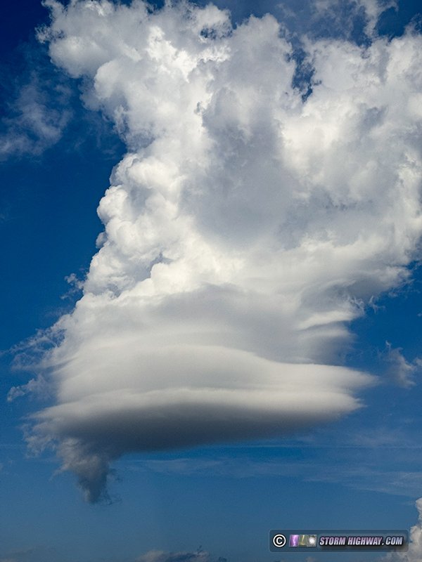
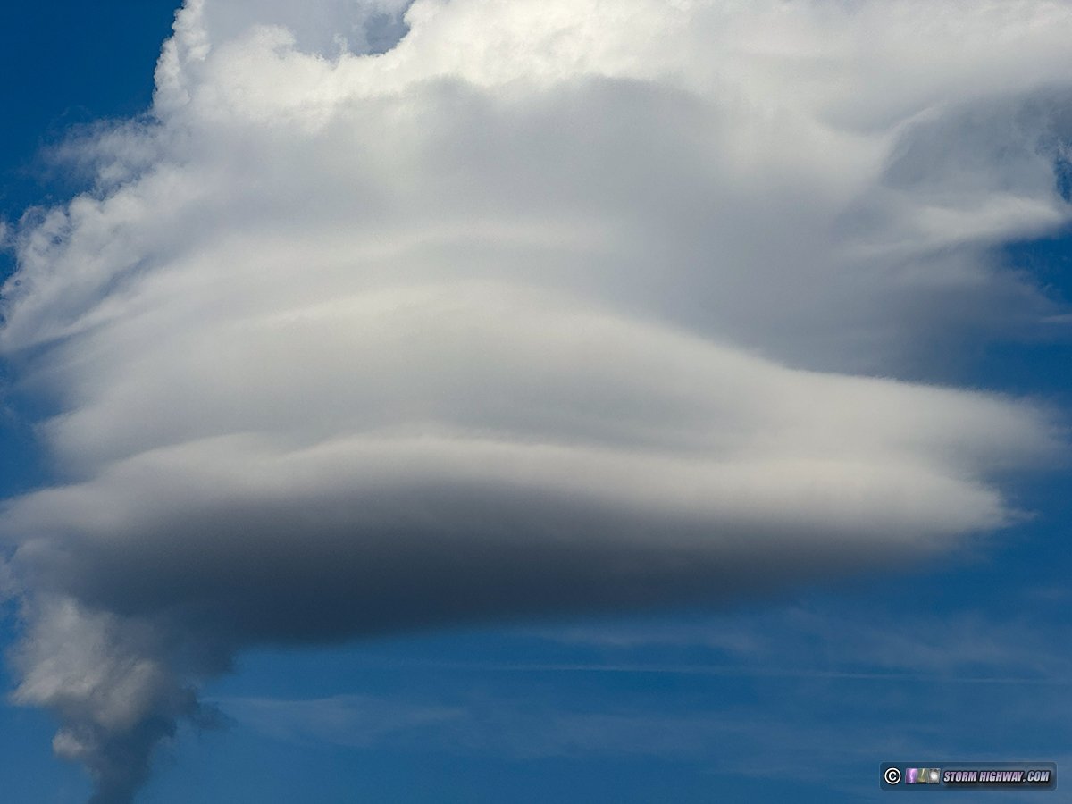
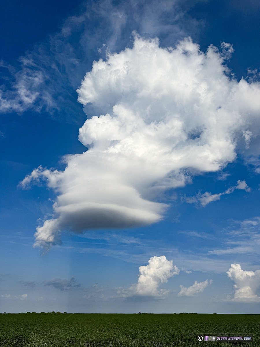
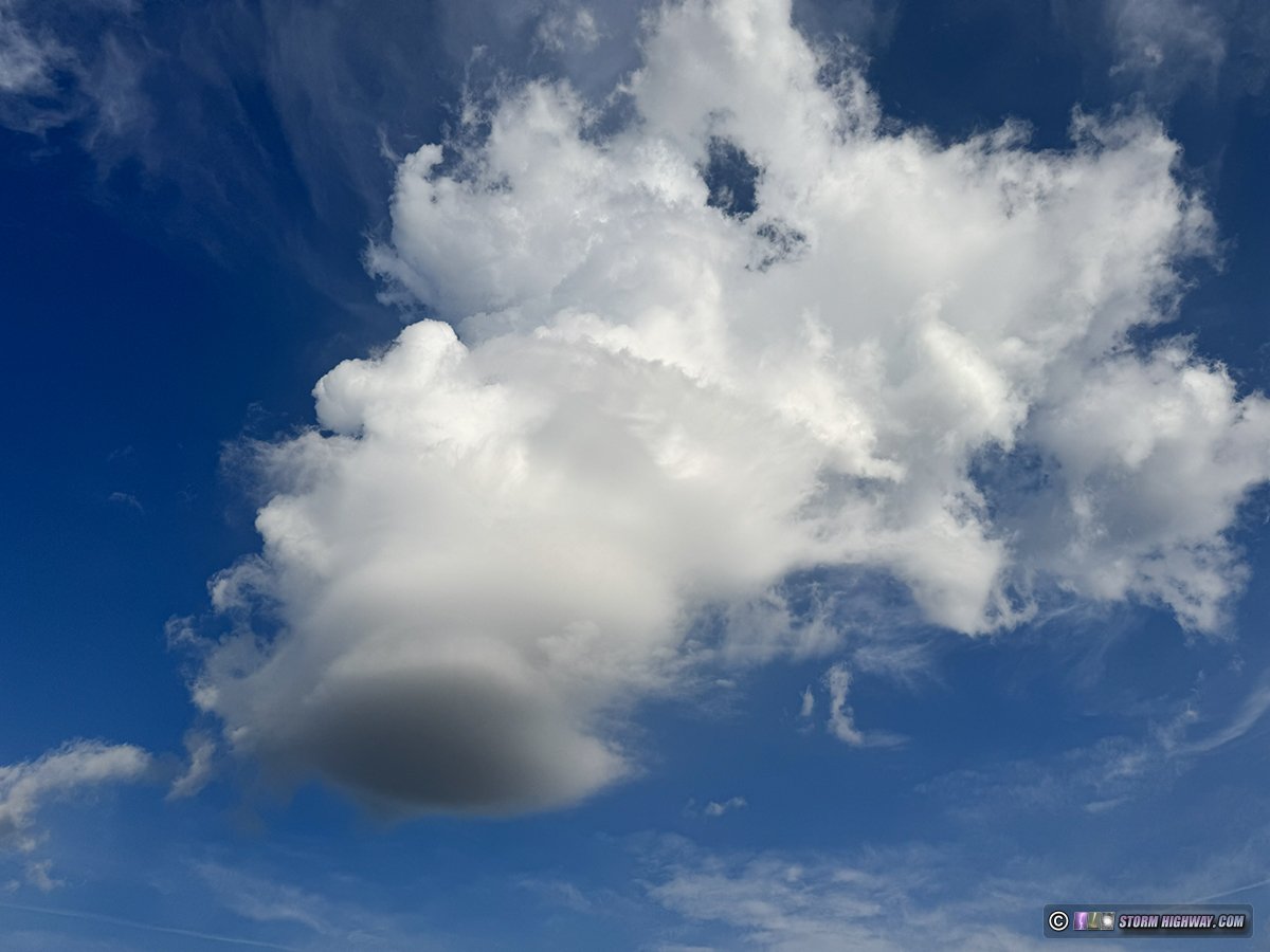
April 17 (morning): Towering cumulus lenticularis over New Baden, IL
A nice treat on the way home from a midnight shift as convection began percolating in the morning light over town. This normally-unremarkable cloud type was made a rare highlight by its formation of lenticular bases.
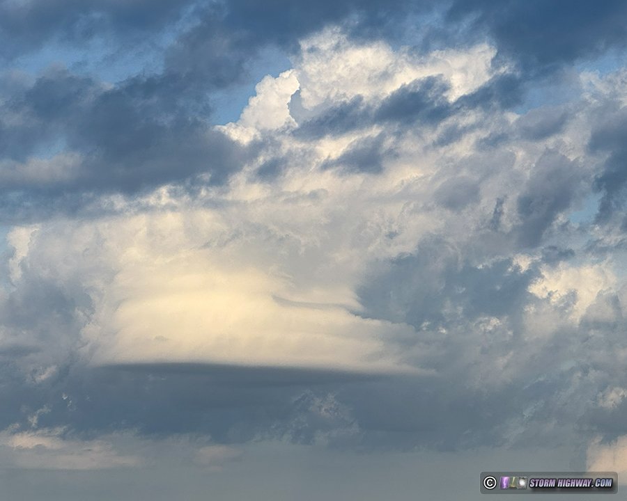
Notice the shadow cast by the cloud in the sky behind it:
Moving overhead with a rounded base reminiscent of an LP supercell:
A stronger updraft to the east, producing a precip shaft, was possibly looking even more impressive that this one - but this wasn't apparent from its backlit side:
April 17 (evening): St. Louis metro storm bust
A short interval of night shifts this week kept me from being able to chase the best areas outside of the metro area, and necessitated setting the alarm for 3pm in case storms fired early close to St. Louis (another direct consequence of the copyright infringement issue - sorry to keep bringing that up, but I want to keep the impacts of that at the forefront of my logs. It's a significantly-relevant part of my storm chasing).
When I woke up at 3, storms had indeed fired and were going severe in the western metro. I drove up to Godfrey to get in front of this activity. The bases were high, lightning infrequent and the storms completely dried up after crossing the river.
After sunset, I headed to Weldon Spring for the late round of storms. I didn't head west or north to the main tornadic supercell ahead of the line at Troy, as I was anticipating some mesovortex circulations on the line in the heart of the metro area. These never materialized (thankfully), and there was no lightning nor any other subjects of note with the weakening line as it traversed downtown. April 24: 50 miles-distant lightning from New Baden, IL
Another backyard outing to shoot distant lightning after work. This storm was down near Selma, Missouri, about 50 miles away. The traffic streaks at the bottom are on Interstate 64.

April 26: Supercells and close lightning from Riverton to Altamont, Kansas

April 27: Mammatus clouds over the Arch
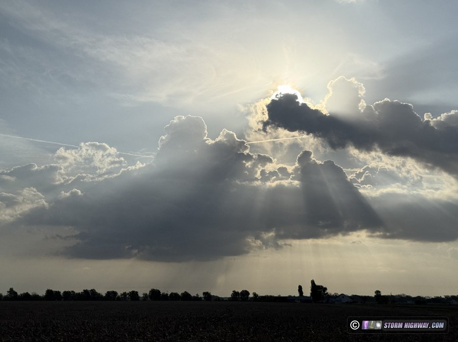
Tornado outbreak forecasts for populated areas, particularly my home city, are things I'm always glad to see bust. While this event wasn't tornado-less in the metro, it certainly wasn't anything like conditions appeared to be setting up for. The outflow boundary from morning storms was expected to be the focus for tornadic supercells in the St. Louis region in the afternoon. So, my target was home this day.
I headed into the city for the first round of storms just after noon. One of these appeared to be setting up to reach out toward intersecting boundaries just ahead of it, but it was still very early in the day when conditions aren't as unstable. Nonetheless, I felt this wasn't something to ignore. As I made my way downtown, this area began looking ominous as a rear-flank downdraft was visible on radar pushing out toward the boundary intersection, and a hook echo was developing. I arrived at my viewing location just after the tornado warning was issued. This was my aerial view of the storms over and west of the city:
This storm remained north of the outflow in the stable air, so it thankfully never got close to producing a tornado as it tracked almost exactly in the same path as the May 16 tornado last year.
This storm and another just behind it actually worked to suppress further tornado activity in the metro area: they reinforced the outflow with fresh surges of stable rain-cooled air. This made the boundary sag to south of I-64 before stalling.
The task as a chaser was to be where a storm could have its updraft reach south of this boundary so it could fully ingest the warm, unstable air south of it. The boundary itself would provide a lot of the 'spin' needed for tornadoes. The issue was that the only storms were going up north of the boundary in the cool air, and none were turning right enough to have any chance of 'grabbing' the boundary. Furthermore, no storms were firing to the south. By 3pm, there were no viable options for imminent tornadoes in the metro area (and again, that was a good thing).
Finally, storms began going up west of the city, in position to reach the outflow boundary. The problem was that they all went up too close to the advancing cold front, which rapidly undercut them. Finally, a storm managed to go up ahead of all of this near Sullivan, quickly organizing into a supercell with a strong mesocyclone apparent on radar. I positioned on the Illinois side of the river to await this, but the cold front ended up catching it and wiping it out before it reached the river.
Now out of viable tornado options, I decided to just go downtown and see if the sunset-lit back side of the storms would offer anything interesting. There was indeed some nice lightning to the east, so I set up in the golden light shooting short time exposures. Alas, the best sky-filling 'anvil crawler' flash happened in the brief gap in between exposures.
After this moved too far away to shoot, I packed up and got back into the car. But just as I started driving away, the sky suddenly exploded in a display of high-contrast, dramatic mammatus - the best I'd seen over downtown St. Louis. I parked again and ran down to the Arch grounds to grab what shots I could before it was gone. These were the best:
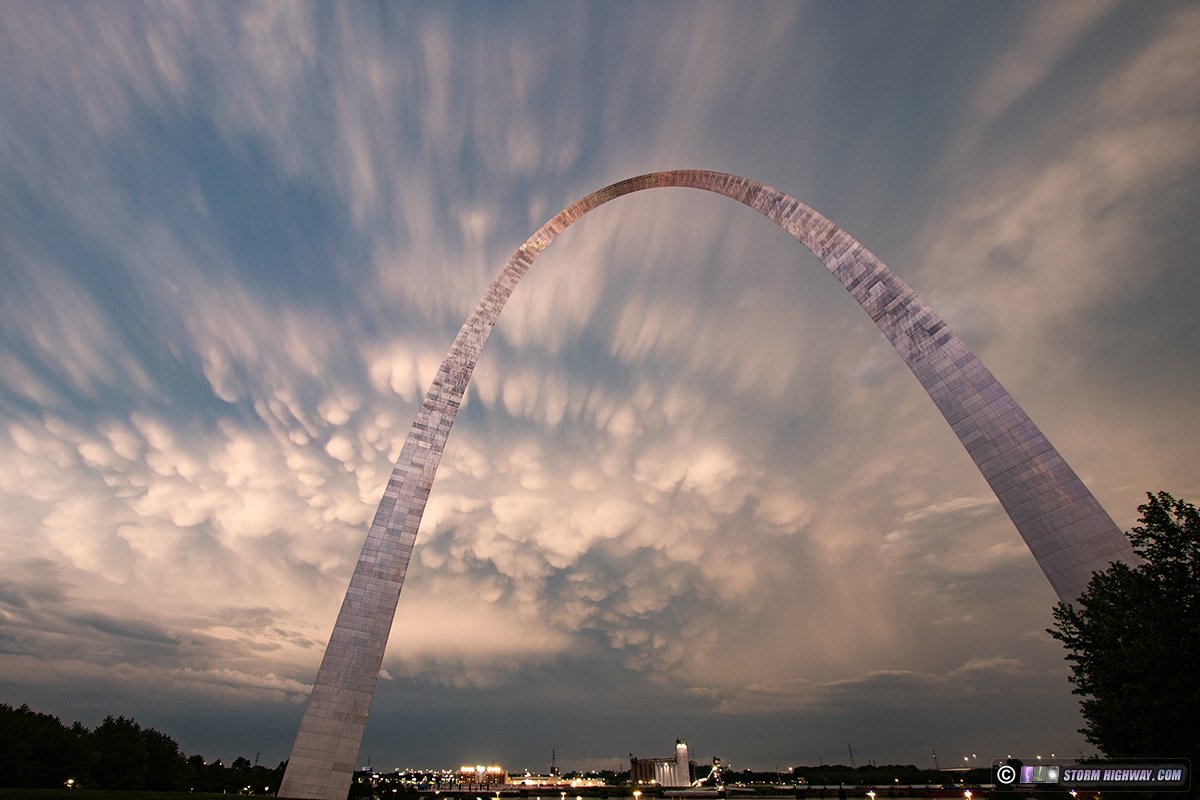 Click to order a print Click to order a print
 Click to order a print Click to order a print
 Click to order a print Click to order a print
While this was going on, the cold front storms had managed to ingest the earlier outflow boundary and produce at least two rain-wrapped QLCS tornadoes to the east: one right north of home at New Baden. I arrived to find the power out in the western end of town and along I-64 to the west.
I made a pass through the radar-indicated track, finding damage in a path that was almost exactly like the EF2 tornado last March 14 (2025), just shifted 1/2 mile north. This tornado was not as strong: I only found two locations of clear tornado damage. The worst was just south of Trenton where a home along Highway 160 had suffered extensive tree damage with several large tree trunks snapped. April 28: Lightning over St. Louis via drone
I didn't think the supercell risk in southern Missouri would be worth spending sparse travel funds on, so I decided to stay in St. Louis and see if models were right about the chances for lightning-active storms in the metro area after dark. These exceeded my expectations, with vivid quality lightning over downtown. I filmed via drone in order to capture the storms as they moved behind downtown to the southwest:
 Order a print of this photo Order a print of this photo


Video:
< January-February 2026 Recap | All Storm Chase Logs | May-June 2026 Recap >
GO: Home | Storm Chase Logs | Photography | Extreme Weather Library | Stock Footage | Blog
Featured Weather Library Article:
|


