|
Home | Blog Index | Blog Archives | Christianity & Faith Essays | Storm Chasing Essays
Annual March 1 post
It's that time of year again! We've made it through another long winter to the date storm chasers around the world celebrate: the start of meteorological spring and severe storms season in the Great Plains and Midwest. The green trees, warm temperatures and open roads of the Plains await us - and of course, the most spectacular storms on the planet!
With the cessation of the professional aspect of my storm chasing operation last fall, I'll be limited to roughly one-half to one-third of my usual spring chase budget this year. Despite all of that, one or two multi-day Plains chase expeditions should still be doable, Lord willing, should the conditions present themselves. Other than that, not much else has changed regarding my setup and focus for this storm season. I'll have all of the same cameras and equipment from earlier years, focusing mainly on aerial storm imagery/video and high speed shooting of lightning in both the Great Plains and here at home in the Midwest. The biggest addition to my gear this season is a lithium power station that will allow plugging in and powering my cameras away from the car. It will run my high-speed camera for several hours or my main A-camera for the entire day, eliminating battery swaps and opening up mainly city photography of storms where the viewing spot isn't close to my parking spot (a problem that has hindered several angles mainly here in St. Louis and in Chicago).
So, what do we have in store for the first week or two of meteorological spring? Right off the bat, the first week of March looks active for storms. After a lead shortwave brings severe weather chances to the Midwest on Wednesday (the 4th), a second larger wave is shown taking shape to the west, spreading strong southwesterly flow over the Great Plains. The second wave is shown stalling in this configuration, with at least two days of supercell/tornado potential in the central and southern Plains on Thursday and Friday. Moisture from the Gulf is shown surging north for all of these events, with at least 60°F dewpoints making it to Kansas and Missouri. And finally, storms are shown developing in the areas of highest supercell/tornado potential on all three of these days.
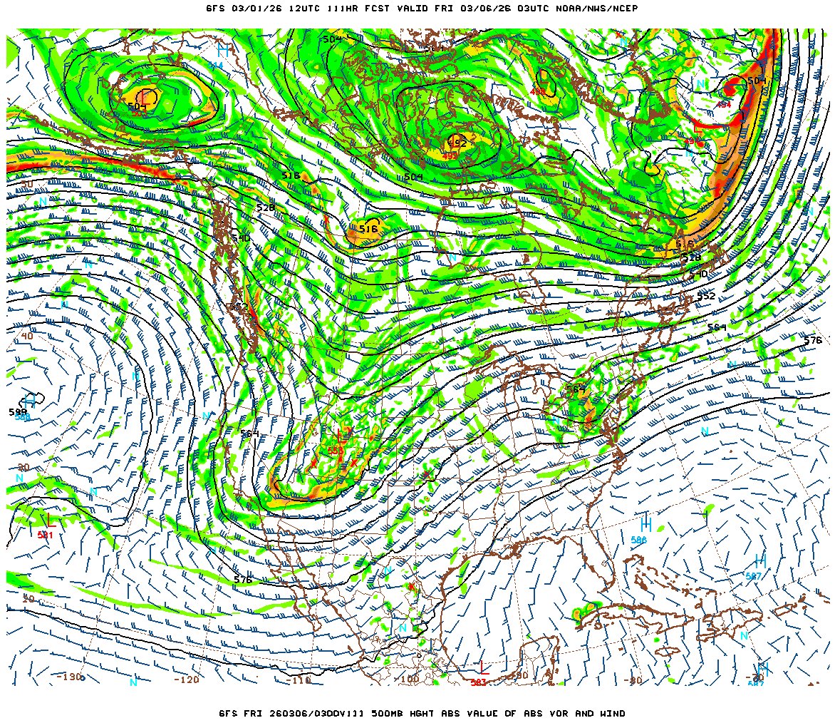
GFS 500mb forecast for Thursday evening (March 5)
Right now these don't look like huge outbreaks, but all of the ingredients will be present for at least a few tornadoes. The biggest potential negative is that capping is shown to be weak or nonexistent, which could mean messier storm modes and/or too many storms going up that interfere with one another. If the waves can slow a little and allow better moisture to be carried north, these could trend upward in the coming days. The jet is shown remaining in place in the period following, with multiple shortwaves that could provide more severe storm chances in both the Plains and Midwest. Most notable is the models' lack of strong cold fronts pushing the moisture back deep into the Gulf, keeping it - at worst - along the coast. Such a configuration would allow easier recovery in advance of each successive wave.
At this stage, nothing looks Plains-expedition-worthy, but there is a good chance for one or more Midwest chases in the coming 10 days.
| 2026 Plains Chase Expeditions - Probabilities as of March 1 |
| March 1-4 | 0% | |
| March 5-10 | 10% | |
|
GO: Home | Storm Chase Logs | Photography | Extreme Weather Library | Stock Footage | Blog
Featured Weather Library Article:
|


