|
Home | Blog Index | Blog Archives | Christianity & Faith Essays | Storm Chasing Essays
January-February 2026 Storm Chasing Recap
The new year started with a snow squall in Washington, Pennsylvania (Pittsburgh area) then a wintertime severe storm risk back in St. Louis. The last half of the month was marked by brutal cold and multiple winter storms. February was mostly queit, aside from a tornado risk on the 19th.
January-February 2026 Event List
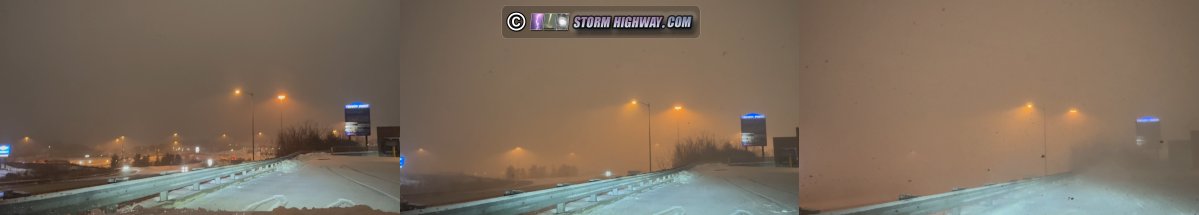
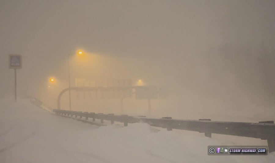
 January 1: Snow squall in Washington, Pennsylvania January 1: Snow squall in Washington, Pennsylvania
This snow squall moved through the Pittsburgh area right after the start of the new year, passing over Washington just before 1:00AM. This was the first time I've been in a snow squall warning, a new type of warning the National Weather Service started issuing a few years ago. Lightning was reported in several locations in the line, but no flashes happened over Washington. A few mesovortices were apparent on radar as the line approached. The precip type was a mix of graupel and snow, resulting in a quick 2 inches of accumulation on top of the 2-3 already on the ground from earlier in the evening (Radarscope screen grab included):
 January 8: St. Louis metro supercells January 8: St. Louis metro supercells
A potent negatively-tilted trough moved through the Midwest on this Thursday as strong southerly winds at the surface brought dewpoints into the 60s F to north of Interstate 70. With excellent shear in place with that kind of moisture, the stage was set for the first tornado risk of the year for the St. Louis metro area. The three major tempering factors were all-day cloud cover (meaning low instability), boundary-parallel flow (which favors linear convection instead of isolated cells) and the strongest activity occurring on the eastern edge of the better moisture, limiting the time storms would have to take advantage of the environment. Furthermore, everything would be after dark. With it being a backyard event though, it was worth going out for a couple of hours to watch.
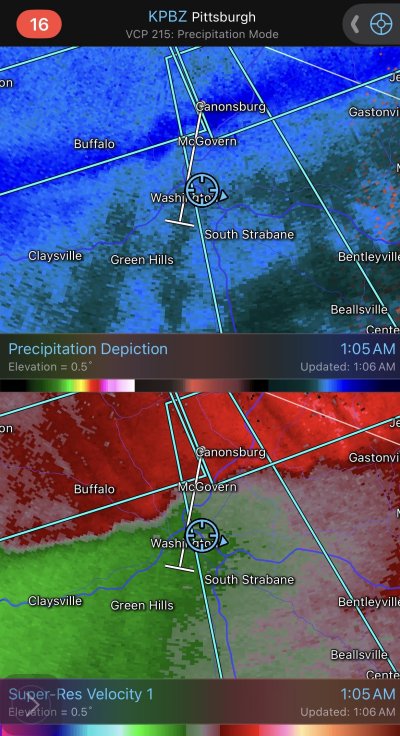
I stayed on the Illinois side for this chase, first sending the drone up at Fairview Heights to watch a tail-end circulation wrapping up over Collinsville. I could not make out any storm structure with that, however. Next I headed up to Glen Carbon for another tail-end cell on a newly-developed line segment. This one had some visible organization, with an RFD clear slot nosing into the base and an inflow tail curving around to the east and south (Radarscope screen grab included):


Motion was weak in this feature as it raced away to the north. I intercepted one last tail-end cell at Marine that had no low-level organization. Storms to my southeast began intensifying as I neared home, but they were out of play thanks to their rapid speed - there was no way I'd get ahead of them at that point.
I did see the first lightning flashes of the year today, but no visible channels exited the clouds.  January 17: St. Louis surprise snow January 17: St. Louis surprise snow
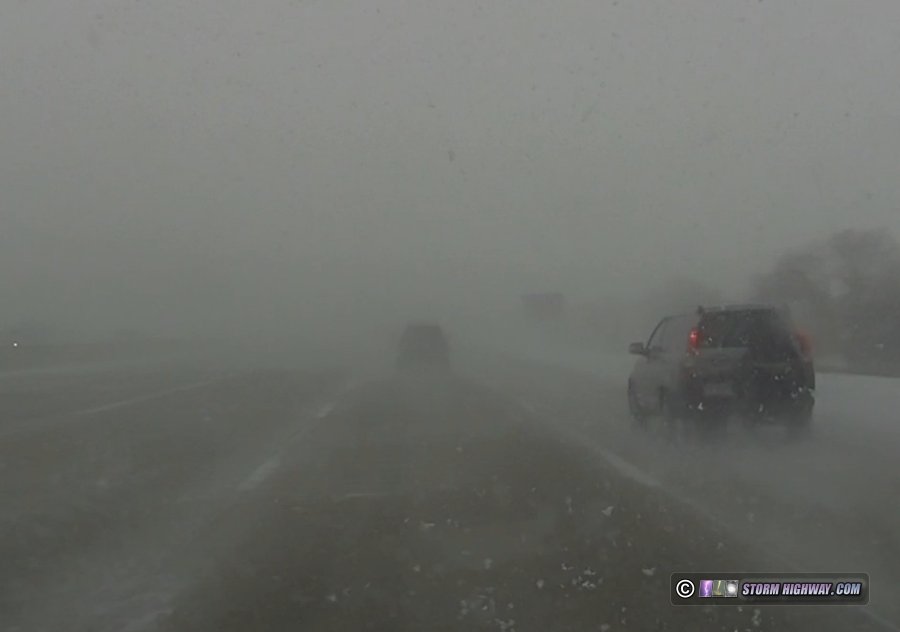
I had this weekend off, so I was originally planning to use it to go to southern Georgia for another deep South winter weather event. Meanwhile, models were hinting at some light snow in the St. Louis metro in the morning - but when I first checked radar after waking up, I was surprised to see heavy snow squalls had developed west of the metro. With temperatures in the low 20s, this meant trouble for St. Louis. Suprise winter precipitation like this means that the DOT crews will not be prepared. which often results in a high-impact road icing event similar to what happens in deep South winter storms.
I left home at 8:30am at headed to St. Charles, hitting the first snow squall at Earth City:
The snow was very dry and powdery, and interestingly was mostly being blown off of the highway by traffic. This kept most of the interstates passable. Ramps and side streets were another story - these quickly became treacherous. I ended up at Highway 40 (I-64) at Ballas Road where vehicles were sliding on the sharply-curving eastbound exit ramp. I captured this footage via drone:
Thankfully no one was hurt in that incident. I had to stop flying as another snow squall moved in, as there is a 3-mile visibility requirement for drone pilots (that I'm planning on but haven't yet got a waiver for). After this last squall moved away, the combination of the DOT crews finally arriving and the direct sunlight helping with melting was resulting in things clearing up fast. So, I was done shooting at 11am, a near-record for my shortest winter weather outing in St. Louis.
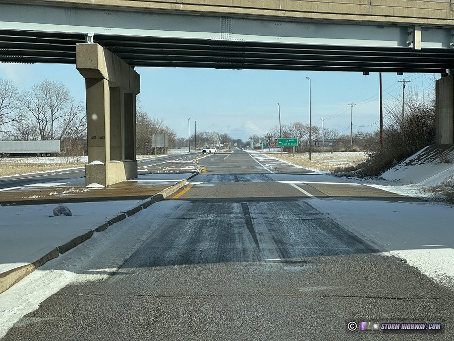
On my way home, I encountered "shade ice" on IL 161 under the I-64 overpass. This is something I've only seen in the South. With no road treatment in those areas - after a storm - the sun and the return of warming temperatures melts everything except shaded spots next to tree canopies, buildings and under bridges. These can have the same effect as an icy bridge, where drivers encounter these sudden icy patches among mostly-clear roads. This is the first time I've observed it in St. Louis, thanks to this surprise event resulting in little to no treatment of the roads.
Interestingly, the HRRR model did pick up on this potential the night before. This is the 24-hour LCR chart at 00z on Friday night depicting a high risk for impactful road icing in the metro:

 January 18: Southern snow turnaround January 18: Southern snow turnaround
As I mentioned in the previous entry, I was originally planning on heading down to either south-central Georgia or the Florida panhandle for the expected snow event on Sunday. With the piracy and infringement issue decimating my operating revenue, I have very limited funds for out-of-area winter weather trips. I can now only afford to do one or two of them per season. The St. Louis snow event made me late for my planned departure time for this trip, so I was running out of time. I needed to get some more sleep for what would be a long overnight drive, arriving just after the snow began down there. After a nap, I left home at 9pm, about 6 hours later than originally planned. I'd be arriving at sunrise, just after the snow was expected to begin.
I made my first data check stop at Marion. While models had come in a little colder and a little heavier on the snow amounts, the window for high road impacts in the heart of the storm appeared to be very short. Temps were only shown falling to 31°F, though I expected a few isolated spots might briefly reach critical icing temperatures (29°F) in the heavier snow. But those conditions would be short-lived, only 2 or 3 hours, maybe 4 - and the sun would be coming out around noon, spiking temperatures rapidly into the mid to upper 40s. With only 3 inches of accumulation tops, this would likely result in most of the snow on the roads melting by late afternoon. I've observed that happen down there before, with much more snow and much colder temperatures than this.
Furthermore, the bigger threat appeared to be Sunday night into Monday morning when temperatures well below critical would spill southward over the snow swath, refreezing anything still on the roads. But I felt that there was a good chance there would not be much snow left on roads after the midday melting took place. 2-3 inches of snow will melt very fast in those temperatures. A 3-4 hour window to shoot a winter storm is just too short to be practical, and I was already running behind and would lose at least an hour of that due to being late. I felt like the chances of not seeing enough significant impacts to capture any compelling footage was too high, so I turned around and headed back home. In a normal year, I'd have made the trip without question - but in these times of infringement and piracy, unfortunately I have to be very selective.  January 20: Magnitude 3.8 earthquake January 20: Magnitude 3.8 earthquake
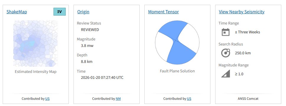
A magnitude 3.8 earthquake occured at 1:28AM near Taylorville, Illinois, about an hour's drive north of here, and was widely felt throughout the St. Louis metro area. A queit night at work was ideal for my experiencing the event. The building creaked, monitors visibly shook and the desk chair I was in was solid enough to clearly transmit the shaking for about 5 seconds. This broke my lifelong curse of missing felt earthquakes on solid ground. The only other one I experienced was in my car during a M4.5 Ridgecrest, California aftershock, with the car's suspension shaking but not really transmitting the true ground motion. In all other notable quakes, I was either driving or had just left the location days earlier. Nice to finally cross that off of the life experience list!
A M3.8 is typically on the low end of perceptible earthquakes, especially any distance away. But as of the time of this posting, the USGS DYFI (Did You Feel It) page has already received more than 1,100 reports, most from the St. Louis metro area. My report was estimated at III on the Modified Mercalli scale. The volume of reports is clearly biased toward St. Louis. I'm not sure if that is just because of the population center, or if the fault rupture orientation directed more of the energy to its south. The data certainly supports that! The moment tensor (beach ball) diagram shows that this was a nearly pure strike-slip (transform) fault rupture, just like the San Andreas Fault in California.
Even though I don't have anything visual captured from this, it's definitely an event that will be one of the highlights of my 2026!
LINK: USGS page on the event

January 20: Clouds lead to an Aurora bust
After this much-hyped aurora event appeared to be a dud thanks to the earth's Bz (magnetic field) being north - coupled with the fact that it was 15°F outside - I didn't plan on going out for this potential northern lights bonanza. Nonetheless, after I got home from work, I saw the Twitter reports of a nice substorm in progress. I drove down to a viewing spot south of town to discover the sky was completely blocked horizon-to-horizon by thick clouds.
January 22-24: Louisiana-Mississippi winter storm
My days off (Friday and Saturday) coincided with this storm's passage, so I decided to take my weekend to go out and oobserve it. I departed St. Louis late on the Thursday and drove to Oklahoma City for what models indicated would be a leading freezing rain/drizzle episode starting Friday morning. This did not occur, so I was able to get a couple hours of sleep that afternoon.
That night, I headed down to Shreveport, Louisiana to spend the night and stage for the main part of the storm. I didn't sleep very well. I got back on the road at 6AM Saturday as sleet and freezing rain had already started in Shreveport. With temperatures still hovering right at freezing, the roads were not very bad. I got back on I-20 and headed east through the morning, trying to reach an area of pure freezing rain - but I never encountered any. Everything was a sleet-freezing rain mix, with occasional heavy sleet. This usually piles up on the roads like pea gravel and is usually not as slick as most other winter precip types, so even as temperatures continued to fall, road impacts were not deteriorating much.
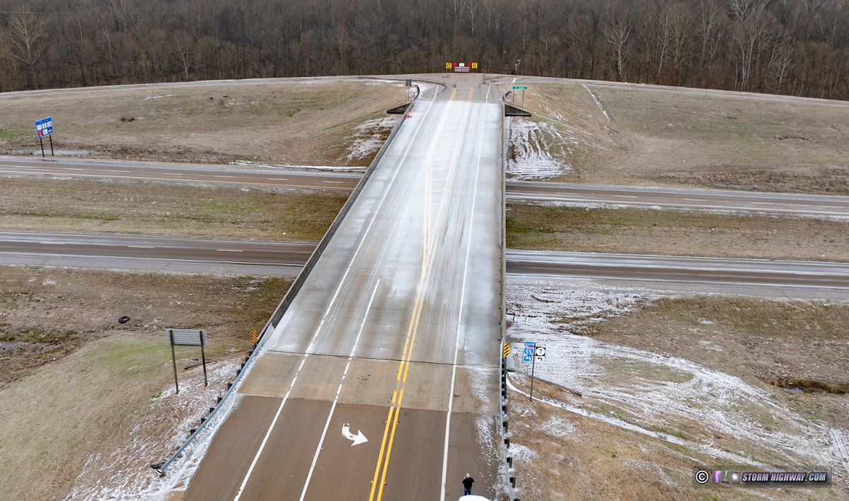
Eventually, I crossed the freezing line at Vicksburg, never finding any pure freezing rain. At that point I decided to head up to northern Mississippi where the main ice storm was about to begin. I crossed back into freezing temperatures near Winona and started encountering icy bridges at Grenada. I identified one on I-55 as a high risk for loss-of-control incidents, but it was not only completely inaccessible (in a swamp, surrounded by woods, no places to park) but there were steep drop-offs on either side of the highway that meant that any accident could be a bad one, with a rollover likely. I don't like those kinds of situations, as I have no desire to witness or capture injuries (or worse). I always look for dramatic-but-no-so-dangerous scenes.
I stopped at the next interchange to get a drone shot of an icy bridge:
I made several passes up and down I-55 and adjacent highways, but found nothing else of interest. I decided to just head north into the ice storm zone. When I did, I passed the bridge in the woods/swamp and there was already a car down in the woods that had lost control. Thankfully they didn't roll, and police were already on the scene.
As I went farther into the colder temperatures, I was back into the sleet-heavy mix that was now coating all roads, not just bridges. I located a few interesting spots for video, but none had safe vantage points to shoot. With twilight imminent, I was out of time for any daytime footage. I had to be back in St. Louis on Sunday. I could have taken another couple of days off, but as I've said, I'm not doing this professionally any longer and therefore can't justify burning excessive PTO for storms. Had this been a 'professional' shoot, I would have stayed in Mississippi for at least 2 more days.
By this time, the main snowstorm was starting in St. Louis. I didn't know how far I would be able to make it before hitting heavy snow, which is very exhausting and tedious to travel in at night (picture the 'starfield simulation' screensavers of old). My speed was already 35-40mph as it was, so any slower would mean an all-night drive. However, as I contiued north into Arkansas and then the Missouri bootheel, I was still in sleet (again, the precip type that is the easiest/least slick to drive on). I didn't hit the changeover to snow until just before Perryville!
It was midnight when I hit the snow line, but I only had 70 more miles to go. Crawling along at 30-35mph, The roads were slick but passable. I made it home just after 2AM. January 26: St. Louis winter storm aftermath
I drove into the city before sunrise this morning to look for any trouble spots that were lingering on the roads. I made a few passes around the typical spots in the metro, but didn't find anything.
February 19: Supercells from Sandoval to Saint Peter, Illinois
The Midwest sees at least one severe storm episode during the winter months annually, and this was that event for the 2025-2026 cold season. A potent upper trough would result in 60°F dewpoints making it all the way to the I-70 corridor as a dryline swept in from the west underneath the fast upper flow. Models were consistent on two rounds of supercells, one beginning by late morning in St. Louis and sweeping through the I-70 corridor toward Indianapolis, then a second more classic arc of cells on the dryline east of St. Louis closer to sunset. A warm front was situated roughly along I-70 from St. Louis to north of Effingham, which would provide the best chance for a tornado if a storm could sustain in its vicinity.
I favored the second, later round of storms for more classic supercells in better terrain, but didn't want to write off the early activity. I figured I'd have enough time to stay with the early storms for a while, then let them go and head back west for the second round.
My morning target was home. I left before noon to intercept the first round of storms passing by to the north, but these and another area of cells to its southeast failed to organize. I stayed with the southern area east to Huey before deciding it was total garbage, abandoning it and heading back west for the second round later. An area of new storms was trying to go up closer to the warm front at Edwardsville, so I headed up to Staunton to get in front of it. This too never took off, so by 2PM I was completely done with the first round.
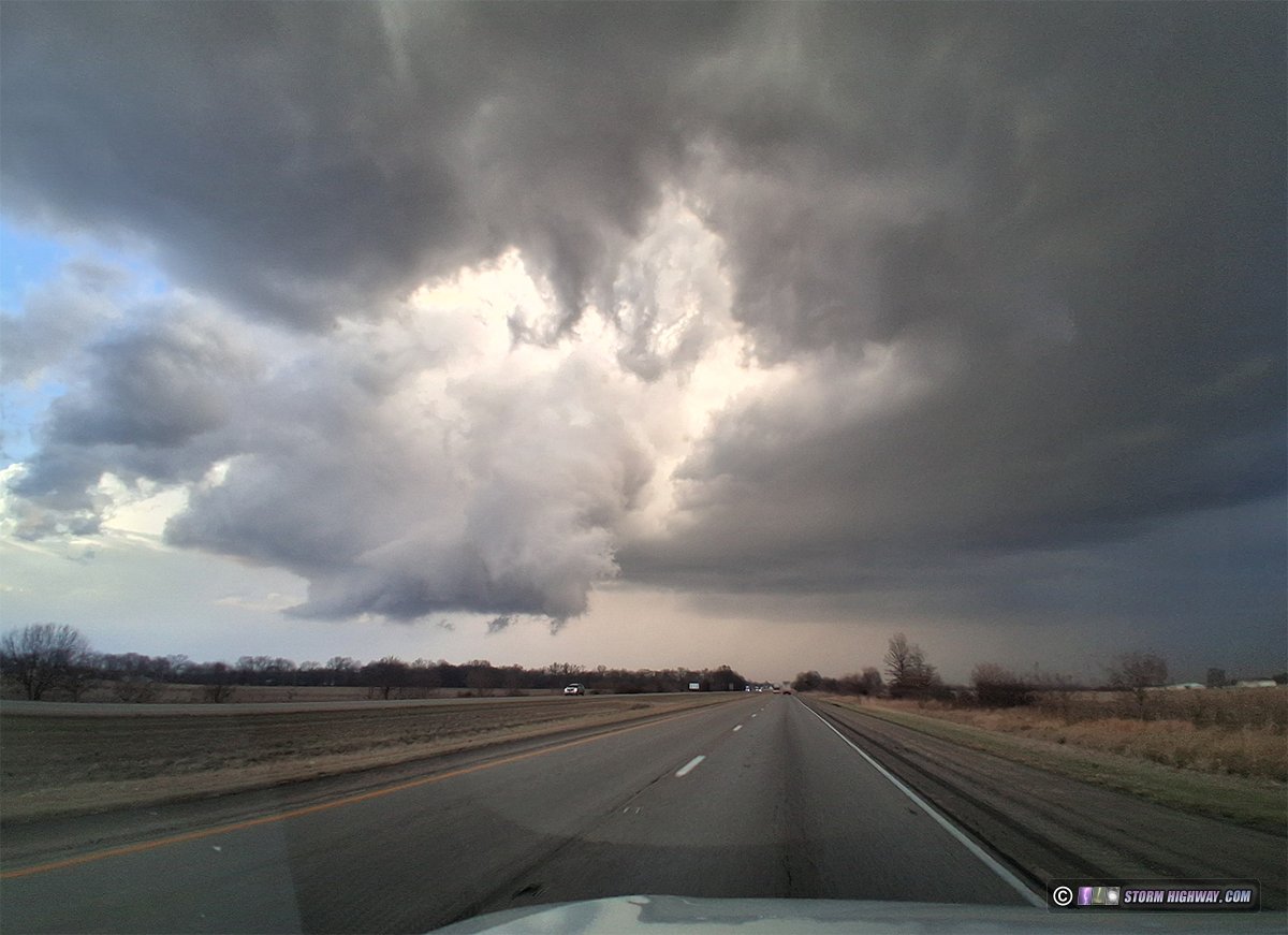
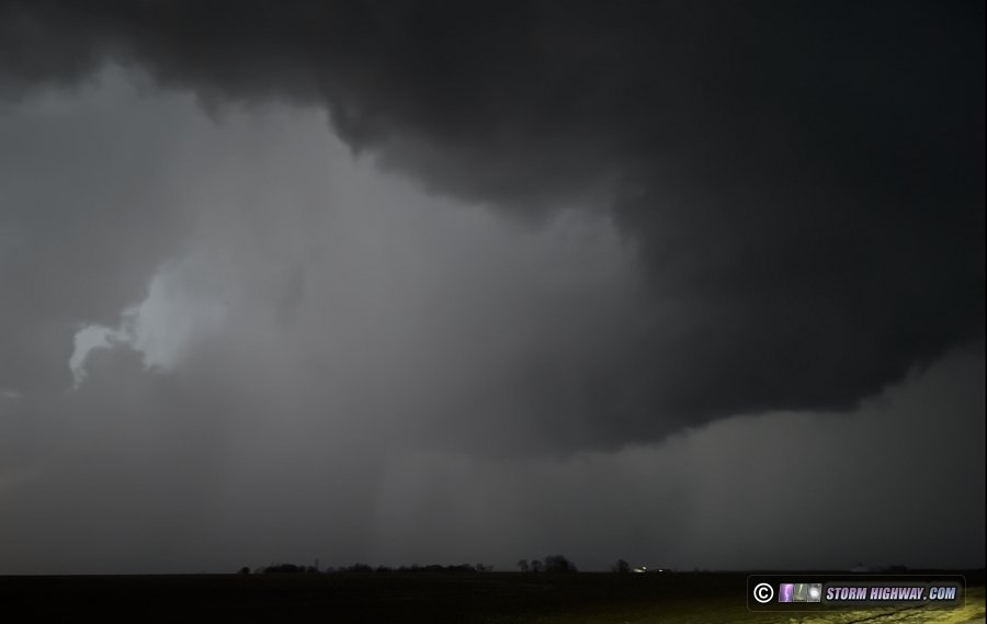
Models were not doing well with the day at all, so I was essentially going satellite-only for assessing the second round of storms. A cumulus field to the southwest of St. Louis showed where this was likely to begin. I hung out near Marine waiting for these storms to appear, expecting one anywhere from St. Louis through Litchfield. Finally a few blips on radar appeared south of St. Louis, tracking toward the Okawville-Carlyle area (just east of home). I headed down to Highway 50 to position ahead of these, finally reaching the lead storm at Hoffman. It was not very impressive at first, high based and only producing a lightning flash every 5 minutes. But as it passed over me at Sandoval, a large RFD surge began and within 10 minutes I was in a huge clear slot with an ominous wall cloud taking shape just to my north.
I intercepted this on I-57 south of Kinmundy:
The wall cloud was rotating strongly, but appeared ragged in the low levels. It began to fall apart as I closed in. After I exited at Kinmundy and positioned for another intercept east of there, the storm's appearance had diminished considerably. The wall cloud had been quickly replaced by an arcus cloud surging east on the RFD gust front, with the wall cloud mostly gone and no focused area of rotation. The storm's VIL core was also shrinking, and it appeared the now-tornado-warned storm at Mount Vernon was likely cutting off this storm's inflow.
A third supercell to the northwest appeared to have a better inflow trajectory with nothing upstream, so I made the short jump over to it at Saint Peter. It had turned, was moving due east and had a decent look as I approached it:
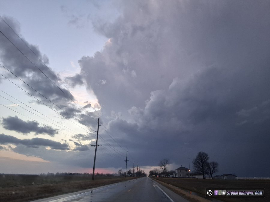
This storm was tornado-warned here. I drove through Saint Peter as their sirens sounded. Arriving on the storm just west of town, a strong RFD surge was apparent, but surface inflow was weak and very cold. Similar to the Kinmundy storm, an arcus formed on the RFD gust front and the storm did not appear to be on course to produce a tornado:
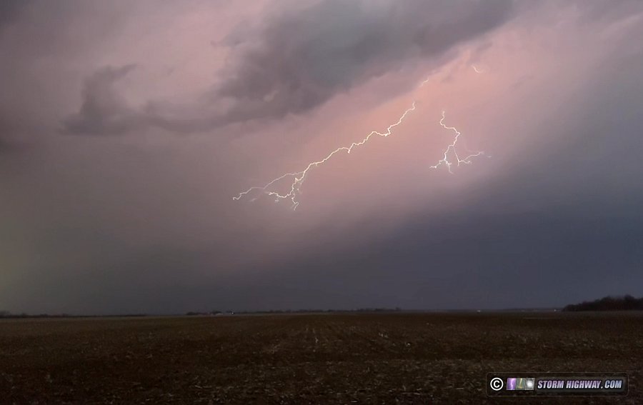
Lightning was frequent in the forward flank, but not photogenic enough for stills and and not bright enough for the high speed camera. This from a cell phone video grab:
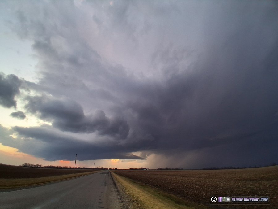
I moved east to stay just ahead of the RFD. It caught up to me east of town, ripping my driver's side door out of my hands and nearly bending the hinges as the door slammed against its stops. To the north, the RFD curled in to where a tornado would be expected, but motion was weak:
With daylight gone, the storm's appearance not improving and heading east of I-57 into worse terrain, I decided I was done. I made it home at 7:30PM.
< December 2025 Recap | All Storm Chase Logs | March-April 2026 Recap >
GO: Home | Storm Chase Logs | Photography | Extreme Weather Library | Stock Footage | Blog
Featured Weather Library Article:
|


