| July 26 missed Gateway Arch lightning strike: No image with this segment, just a lamentful account. It's been a long time since I've had such a crushing storm chasing failure - this defeat made me feel sick for two weeks.
It had been over three years since the Arch was last struck by lightning at night (April 10, 2013). As visitors to this site know, I've been trying diligently for almost seven years for this shot. Arch lightning strikes are actually quite rare - once a year (or less). I know the true frequency of these events since I'm downtown with cameras on the Arch for 95% of St. Louis storms. I did catch a somewhat-passable daytime strike on a single HD video frame in 2014, which was the last known strike in two years (before July 26, 2016) and only the fourth one I know of that has happened since I moved here in 2010.
The evening of July 25 saw a marginal severe weather risk, with 10-15kts flow aloft and strong instability areawide. It was a routine nighttime thunderstorm event that I'd be downtown for. I began in St. Charles, chasing the first line of thunderstorms going up west of St. Louis. These storms were qickly outflow dominant, had frequent in-cloud lightning flashes but very little in the way of visible cloud-to-ground bolts - really disappointing visually. They were also moving slowly northeast and looked to miss downtown altogether. A small new storm went up south of downtown, drifting very slowly northeast. There were three factors influencing my decision at this point: 1.) the lack of visible lightning I'd seen with the previous activity to the north and west, 2.) the general northeasterly motion of all of the storms in the area (they looked to all miss downtown), and 3.) the fact that it was midnight and I was tired from waking up at work at 5AM (and had to wake up *again* for work in a few hours). I went home and went to bed.
I woke up at 5AM for work, and decided to run a 200-frame COD radar loop to see what the storms had done. After I went to sleep, the storms congealed into a solid line east of the city (not unexpected), then unbelievably peaked in intensity while propagating/backbuilding WEST right over downtown! I have never seen a squall line in +10kts upper flow do that in my life. I have replayed the scenario in my head 100 times, and can't think of any way I would have seen that coming and known to stay downtown, especially facing the prospects of a 32-hour no-sleep marathon during work the next day if I stayed out all night for storms. It was such a fluke of the atmosphere that I can only conclude it just wasn't meant to be.
I found out the personally-devastating news that the Arch was struck during this event by searching on Twitter and finding this video shot by Zachary Hall.
So, I'm 0-for-2 on the only two nighttime Arch strikes that have happened in 7 years (I missed the 2013 one due to the streaming-for-TV debacle). I'm incredulous on how much time, effort, lost sleep and downpour-soakings I've put into attempts over the years, and still manage to miss it twice. I guess it will be another 2-3 years of feverishly running downtown for every St. Louis storm before I get the next chance. This shot has been turning out to be the most difficult of my life to land, and after this last miss, I'm beginning to realize there's a real chance I'll ultimately not be successful.
All that being said, I have a blog post coming sometime in the future about the importance of being thankful in storm chasing. Ironically, I began composing the post in June, before this event. I look back and see Dodge City tornadoes, the Chicago triple strikes and the daytime Arch strike in 2014, Bennington I and II tornadoes, Mulvane and countless other victories. Realizing the improbable success I've had over the years in seeing rare events gives me perspective, and helps me not get utterly defeated for repeatedly failing at what has arguably been the biggest effort for a single photo I've ever undertaken.
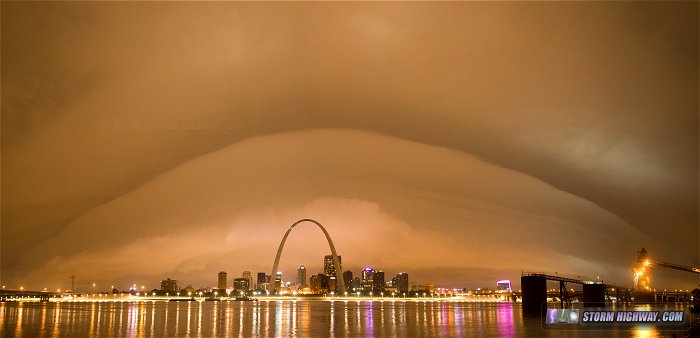
August 3 - St. Louis overnight shelf cloud: This was the storm to pick myself up off the ground, dust off and keep trying for the next nighttime Arch lightning strike. The storms collapsed west of the city, creating this dramatic shelf cloud illuminated only by the city lights at 3:30AM:
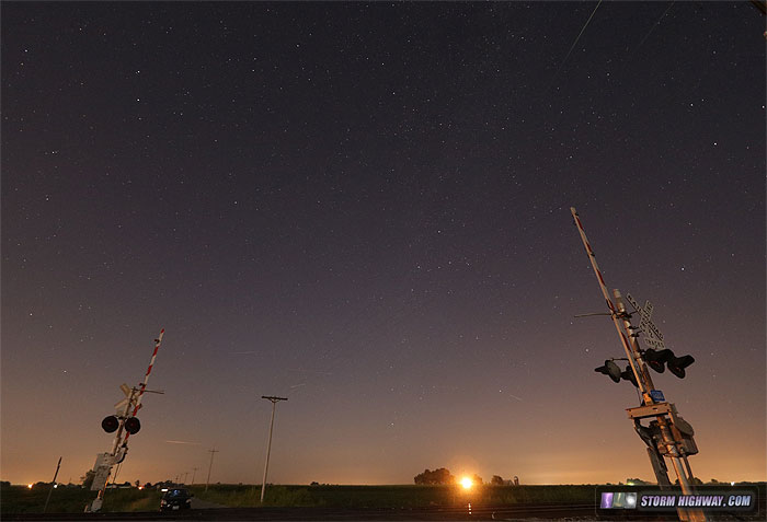
August 11 - Persied meteor shower: My daily 5AM wakeups for work make all-night meteor shower or aurora shoots hard to pull off, but I did go out for about an hour on the night of the 11th to see what I could get out of the Perseids. Since I was out early during full moonlight, my only option was to shoot northeast. I saw a few bright fireballs to the east and west of my frame here, and only captured a few weak ones in frame to the north. I put together this stack of six of them. Most are hard to see, aside for two of the fireballs that began at the top of the frame.
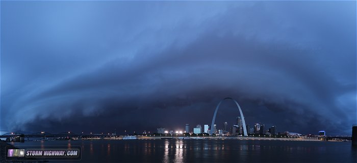
August 12 - St. Louis evening shelf cloud: The Blues at the Arch festival shut out my usual east-facing view for Arch lightning strike attempts, so I had to go to the Illinois riverfront to shoot west. Normally this angle doesn't work well for Arch lightning because most storms have westerly wind-blown rain soaking the camera lens. Lightning with this storm was intense to the west, but fizzled as it approached downtown. The incoming shelf cloud was nice, though:
That's it for the little bit of storm chasing I was able to squeeze into my schedule over the last month. As always, thanks for stopping by to take a look.
|