|
You are currently viewing our High-Definition (1080i) footage catalog. Switch to Standard Definition (720x480 NTSC) Catalog or Switch to 4K UHD Catalog
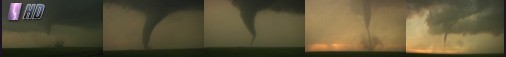
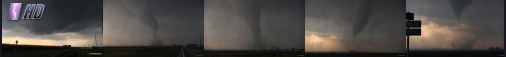
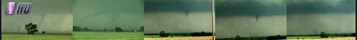
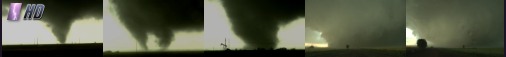 Date filmed: May 31, 2013
Location: El Reno, Oklahoma
Source: HDV 1080i
Speed: Realtime
Class: HD Premium
Description: The EF5 El Reno tornado becomes 2.6 miles wide, the largest tornado ever recorded. Footage shows the tornado at close range in multiple vortex stage, then the storm chaser is nearly caught in the circulation trying to escape. RFD winds on the back side of the tornado blow out the storm chaser's rear window and damages the car.
Sample Clip
More Detail & Screenshots >>
|
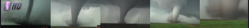
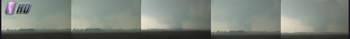
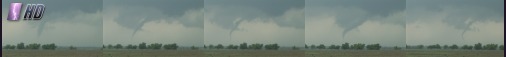
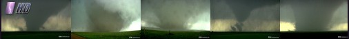 Date filmed: May 28, 2013
Location: Bennington, Kansas
Source: HDV 1080i
Speed: Realtime
Class: HD Premium
Description: A large, violent and long-lived tornado churns across the Kansas prairie north of Salina. Shots of the tornado in many different shapes and sizes, including wedge, cone, barrel, multiple vortex, and more. Includes a sequence shot within 1/4 mile of the tornado, with rapid, mesmerizing motion in the clouds, tornado and debris cloud.
Sample Clip
More Detail & Screenshots >>
|
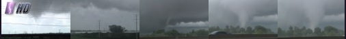
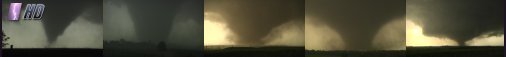 Date filmed: May 25, 2016
Location: Solomon-Abilene, Kansas
Source: HDV 1080p
Speed: Realtime
Class: HD Premium
Description: An exceptionally long-lived monster tornado develops near Solomon, Kansas and roars across the prairie, peaking at EF4 intensity near the town of Chapman. Shots include the tornado developing and two close-range passes.
Sample Clip
More Detail & Screenshots >>
|
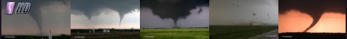 Date filmed: April 14, 2012
Location: Ingersoll, Oklahoma
Source: HDV 1080i
Speed: Realtime
Class: HD Premium
Description: Numerous tornadoes touch down over northwestern Oklahoma during a major outbreak in mid-April of 2012. Shots include an instance of twin tornadoes on the ground at the same time, two close intercepts including a direct hit to a barn a quarter-mile away, and nighttime tornadoes with lightning flashes. An action-packed sequence!
Sample Clip
More Detail & Screenshots >>
|
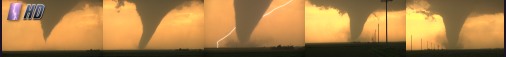
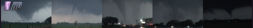
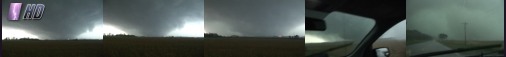
 Date filmed: May 18, 2013
Location: Rozel/Sanford, Kansas
Source: HDV 1080i
Speed: Realtime
Class: HD Premium
Description: A tornado touches down nearly overhead, then puts on a show at sunset as it morphs into various shapes in the golden light.
Sample Clip
More Detail & Screenshots >>
|
 Date filmed: May 18, 2013
Location: Rozel, Kansas
Source: HDV 1080i
Speed: Realtime
Class: HD Premium
Description: One of the most photogenic tornadoes of the decade touches down south of the town of Rozel, Kansas in front of a golden evening sunset.
Sample Clip
More Detail & Screenshots >>
|
 Date filmed: May 24, 2016
Location: Dodge City, Kansas
Source: HDV 1080p
Speed: Realtime
Class: HD Standard
Description: A supercell storm produces numerous tornadoes at Dodge City, Kansas, some highly photogenic.
Sample Clip
More Detail & Screenshots >>
|
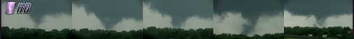
 Date filmed: June 7, 2014
Location: Hazelwood, Missouri
Source: HDV 1080i
Speed: Realtime
Class: HD Premium
Description: A tornado touches down along the Earth City Expressway and Highway 370 in St. Louis with debris flying. A landing jetliner passes through the tornado circulation. The tornado becomes fully condensed after crossing the highway.
Sample Clip
More Detail & Screenshots >>
|
 Date filmed: September 25, 2012
Location: Okawville, Illinois
Source: HDV 1080i
Speed: Realtime
Class: HD Standard
Description: A brief but strong tornado touches down at Okawville, Illinois, about 35 minutes east of St. Louis during a fall season severe weather event in the Midwest.
Sample Clip
More Detail & Screenshots >>
|
 Date filmed: April 19, 2011
Location: Near Litchfield, Illinois
Source: HDV 1080i
Speed: Realtime
Class: HD Standard
Description: A large tornado quickly takes shape near the town of Litchfield, Illinois, on I-55 about 35 minutes north of St. Louis.
Sample Clip
More Detail & Screenshots >>
|
 Date filmed: April 23, 2007
Location: Protection, Kansas
Source: HDV 1080i
Speed: Realtime
Class: HD Premium
Description: With tornado sirens wailing and thunder crashing, a supercell thunderstorm procudes multiple tornadoes within a 20 minute time span. Multiple tornadoes are on the ground simultaneously at one point. Ominous wall clouds rotate rapidly with tornadoes forming and dissipating.
Sample Clip
More Detail & Screenshots >>
|
 Date filmed: May 20, 2010
Location: Sedalia, Missouri
Source: HDV 1080i
Speed: Realtime
Class: HD Premium
Description: The full life cycle of a tornado in Sedalia, Missouri as sirens wail nearby.
Sample Clip
More Detail & Screenshots >>
|
 Date filmed: May 10, 2010
Location: Medford, Oklahoma
Source: HDV 1080i
Speed: Realtime
Class: HD Premium
Description: Tornadoes touch down near Medford and Red Rock, Oklahoma during an outbreak on May 10, 2010, with occasional multiple tornadoes on the ground simultaneously.
Sample Clip
More Detail & Screenshots >>
|
 Date filmed: May 24, 2008
Location: Perry, Oklahoma
Source: HDV 1080i
Speed: Realtime
Class: HD Standard
Description: A tornadic supercell drops funnels and a tornado near the town of Perry, Oklahoma.
Sample Clip
More Detail & Screenshots >>
|
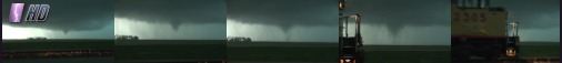 Date filmed: May 26, 2008
Location: Pratt, Kansas
Source: HDV 1080i
Speed: Realtime
Class: HD Standard
Description: A tornado touches down, only to be blocked from view by a passing freight train.
Sample Clip
More Detail & Screenshots >>
|
 Date filmed: September 22, 2006
Location: Near Crosstown, Missouri and Murphysboro, Illinois
Source: HDV 1080i
Speed: Realtime
Class: HD Premium
Description: A massive 'wedge' tornado, rated F4 on the Fujita scale, plows across the Mississippi River valley from Missouri into Illinois during a rare September tornado outbreak in the midwest. storm chasers tracking the tornado get close, with debris raining down in front of and onto the vehicle. This tornado, which crossed from Perry County, Missouri into Jackson County, Illinois, was the strongest ever recorded in this region in the month of September.
Sample Clip
More Detail & Screenshots >>
|
|
|
| Storm Highway Footage is seen regularly on: The Weather Channel, The Discovery Channel, National Geographic Channel, The History Channel, CBS, ABC, Good Morning America, Inside Edition, numerous local TV network affiliates, and more. See a portfolio showing a sampling of on-air credits and aircheck images.
On-Air Credits | Contact Us | Purchase Footage | Rates | Video Library | HD Video | Home
Storm Highway is owned and operated by Dan Robinson/stormhighway.com :: St. Louis, MO - Agent Phone: (605) 770-1624 | Report Copyright Infringement
Web site design by CIS Internet |
|
|