Lightning Season 1998 - Storms in West Virginia
Reflections
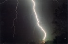
October 18, 1998
1998's lightning season has finally come to a close- and I can say it's been a good summer. This has been by far my most successful storm season, photographically speaking. My first-ever May and September flashes, a close flash hitting a tree, and just a lot of lightning made it a great year. All thanks to the Lord who made it all- and loves me enough not only to die for me, but to make life interesting! I'm looking forward to next year and Lightning Season 1999 . . .
I am come that ye may have life, and that ye may have it more abundant......
Postseason
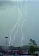
September 7, 1998
 Indian Summer was in full swing early this September, and I was wondering how that approaching cold front would affect the weather when it pushed its way through the warm air here in Charleston. I wasn't expecting much in the way of lightning until I checked the radar and saw that the entire state was under a severe thunderstorm watch. Indian Summer was in full swing early this September, and I was wondering how that approaching cold front would affect the weather when it pushed its way through the warm air here in Charleston. I wasn't expecting much in the way of lightning until I checked the radar and saw that the entire state was under a severe thunderstorm watch.
Late in the afternoon, I checked the radar to find a 50,000 ft-top cell bearing down on the city. The storm's center would pass to the north. I grabbed the camera and was out the door in minutes. I was rested up after the day off (Labor Day) and was ready for a long photo session.
 I got to the top of the Kanawha Baptist Temple hill well ahead of the storm, and set up the camera in the tailgate of the station wagon. Vivid lightning was already visible below the low clouds in the distance, and coming this way. I had a breathtaking view of the Elk river Valley in the frame, too. Perfect. It seemed that way, anyway. I got to the top of the Kanawha Baptist Temple hill well ahead of the storm, and set up the camera in the tailgate of the station wagon. Vivid lightning was already visible below the low clouds in the distance, and coming this way. I had a breathtaking view of the Elk river Valley in the frame, too. Perfect. It seemed that way, anyway.
Well, the gust front arrived not much later. I forgot about the gust front.... Leaves, wind, and huge raindrops forced me to retreat into the car. The rain only got worse, and I decided to pack up and find another spot.
As I drove around, several bright, close flashes lit up the mountains around me. The rain suddenly let up, and I decided to give the hill one more try. By the time I returned, the first storm had gone, and a second smaller cell was flashing just to the south. I snapped a few frames and went home. Not much of a storm, but I was just happy to get a few lightning photos in September- a first for me.
Unexpected
August 10, 1998
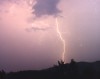
Typically, lightning season in West Virginia is over by the end of July. This year was different. I was standing on the front porch when the small, quiet storm I was watching suddenly decided to get active. The calm, intracloud flashes were quickly replaced by sharp, bright CGs to the east. The storm was moving northwest. The lightning activity was only 2 miles away- and heading right for me.
 I scrambled to get the camera set up, and grabbed the tape recorder and popped a cassette in (I hope there wasn't anything on that tape!) and began recording the storm visually and audibly on my front porch. The center of lightning activity passed right over the neighborhood- the closest flash hit a few hundred feet behind my house (got that one on tape, but not on film). The only photo I got from the storm was a good, bright flash about 3 miles away (at right), which turned out rather well. I scrambled to get the camera set up, and grabbed the tape recorder and popped a cassette in (I hope there wasn't anything on that tape!) and began recording the storm visually and audibly on my front porch. The center of lightning activity passed right over the neighborhood- the closest flash hit a few hundred feet behind my house (got that one on tape, but not on film). The only photo I got from the storm was a good, bright flash about 3 miles away (at right), which turned out rather well.
I have to learn not to underestimate these little innocent-looking storms that can suddenly turn in to monsters.....and have the camera ready to go.......
The perfect summer storms
June 29, 1998
It was a frustrating two days. Training severe storms were repeatedly
barraging the counties just 30 miles north of Charleston both nights.
After work at 2:00 A.M., the 'storm train' would become visible on the
north
horizon, and I would set up my camera and wait. The lightning
activity was so intense that the horizon would seem to be on fire at
times-
the towering clouds illuminated with almost constant bright orange
flashes of light. But, as the storms approached within 20 miles, the
lightning dwindled to almost nothing. The storms continued on to the
east, as if to stop and go out of their way to avoid Charleston. Then,
the lightning would pick up again, and move off into the dark eastern
sky.
After waiting 3 hours after a long day (and night), fighting mosquitoes
and regretting leaving the can of 'OFF!' at home, I went home in a less
than happy mood. This story played itself out two nights in a row.
However, the southeast-moving system was drifting south slowly, and
after a long wait Saturday night, I could tell that Sunday would be the
big day. For once, my hunch was right.
The air was so unstable that storms were already forming at 8:00 Sunday
morning as I got ready for church. I left a little early so I could
take a look at the situation with the clouds. I pulled into the church
lot about 9:20 as the CG's started just off to the northwest. I sat
and watched the lightning approach- I could tell that this storm had
potential. I made a quick drive down to the
 Kanawha City Mall parking lot and caught a flash of the first
storm's lightning as it crashed through town. I made my way back
through the pouring rain to arrive in time for Sunday school...
Kanawha City Mall parking lot and caught a flash of the first
storm's lightning as it crashed through town. I made my way back
through the pouring rain to arrive in time for Sunday school...
The rest of the day was quiet. However, as I left church in the late
afternoon for work, a huge, isolated storm began mushrooming to the
north. It covered the horizon within 1 hour, and after 2 hours the
radar at work indicated the storm had topped out at 60,000 feet. The
stationary storm's lightning began to be visible at sunset as other
storms began to form and move over the entire state. I could tell the
night's activity was just beginning.
I checked the radar before I left work. The sight was unbelievable- a
large line of fast-moving storms was heading southeast right for
Charleston. The northwest sky was aglow with pulses of light when I
walked outside. I got in the car and headed straight for the Greenbrier
street overpass.
If this thing holds together, I thought, this could be the lightning storm
of the summer- and better yet, it's happening at night! Soon, the
lightning channels became
visible in the distance through the dense clouds.
An awesome sight appeared out of the darkness- a low line of squall clouds
on the edge of a gust front were speeding over the city, illuminated by
the city lights. As the clouds approached closer, the wind picked up to a
steady breeze, then to a unbeleivable steady blast of air that lasted a
good 5 minutes. As the wind raged, power flashes illuminated the
hillsides
and the lights in the east end of the city darkened. The streetlights
directly in front
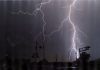
 of me had been cut off by the faulting power lines.
 Soon after the
gust front passed, the wind dwindled to almost nothing, and the lightning
started getting close. My camera was ready- and the shutter-opening
began!
Two magnificent flashes streaked right in my
camera frame during the light show. Soon after I moved to the other
side of the overpass to catch the retreating storm, an earsplitting
crack exploded behind me as a flash hit within hundreds of feet. I missed
getting that one on film, but I did catch the awesome instant blast of
thunder on my audio cassette recorder (hear it here! [WAV, 153K].)
The storm moved on east, and Charleston was quiet again. I was extremely
tired after 3 days of all-night weather watching, and
struggled to stay awake to monitor the continuous string of storms that
didn't stop until 9:30 the next morning.
It was quite a show. A display of the Lord's fireworks can't be beat!
Hopefully it won't be this year's last...
Small storm produces brief but potent show of cloud-to-ground
discharges
June 10, 1998
Sometimes a storm catches me off guard. Today was one of those times.
The phone woke me up at noon (I work at night), and when I walked out of
the bedroom to
answer it, the lightning started.
The cloud-to-ground strokes were getting close. The next one, less than
a mile away, caused a loud click in the phone's reciever.
My camera was down in the car, but I couldn't just hang up the phone and
go. I watched anxiously out of the big picture window, looking at the
scene where less than a month before the Lord gave me one of my best
lightning photographs.
About 40 seconds passed. I saw the bright yellow-white channel split down
in the valley in front of me- followed almost instantly by a loud bang.
Lightning had just struck the hillside across the valley, in almost the
same spot that it had a month before. Except
this time, I didn't have the ol' Minolta set up. Oh well.
That close strike turned out to be the last cloud-to-ground flash of that
storm. I wasn't really upset at missing that one- after all, the Lord's
given me a lifetime's worth of awesome shots. Besides, that's part of the
challenge and excitement of the persuit- if I captured every bolt I saw on
film, it'd get boring after awhile. It was also interesting to just watch
lightning strike that close- with or without getting it on film.
It turns out that one of the flashes struck an apartment building in
Charleston's East End, causing severe damage to the roof and frying the
phone lines (probably causing that click I heard on the phone).
Well, I just checked the doppler. Looks like some storms are in western
Kentucky- headed my way. They'll be here sometime late tonight, if they
hold together.
This time I'll have the camera ready.
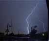
Tornadic supercell moves through downtown Charleston, WV - F1 tornado touches down in Kanawha City
June 2, 1998
Typically, the supercell thunderstorm is associated with the plains
states' famous Tornado Alley. But occasionaly the Lord sends one on east
to the mountains.
A giant thunderstorm that developed in Indiana made its way
southeast at 40 miles per hour through Ohio,
West Virginia, Virginia, and North Carolina, smashing straight through
Charleston on the way. When I saw the storm coming, I didn't realize how
big it was. Only after I got in the car to go after it and the
golfball sized hail started pummelling the car was I aware what I was
getting in to. Unbeknownst to me at the time, this storm had produced
three reported tornadoes just to the west of me in Cross Lanes, Buffalo,
and Apple Grove, WV.
As I turned west onto the Kanawha Boulevard at the State Capitol, the hail
was almost deafening. Visibility was almost nothing. Cars were stopping
in the middle of the road. About two blocks after that, things got pretty
interesting. Debris was flying horizontally, the hail larger than ever,
and the wind rocked the car. I finally realized that I might be in a bad
spot- near or in the path of an oncoming tornado. (A curtain of large
hail and driving rain often enshrouds the tornado vortex.)
I kept thinking, 'this stuff doesn't happen in West Virginia!'. as the
onslaught continued. As I turned down Ruffner Avenue, things calmed
down
a bit. But then I heard the warning sirens go off- this was more serious
than I thought. I made a u-turn and headed back east on the boulevard-
hoping to
get back closer to the action- but the storm was moving away too fast (40
mph, I later found out). I drove past the Capitol and past the 35th
street bridge, but the worst of the storm was already gone. I turned
around and headed back west.
By then, the sun was out- only ten minutes after the driving rain and hail
left visibility at near zero. Damage was light until I passed the Capitol
and Greenbrier street. Beyond Greenbrier, debris covered the road.
Large tree limbs, flags, boxes, and other items were strewn everywhere.
Water 4 to 6 inches deep in some areas made driving slow. Near Ruffner,
(where I turned around in the middle of the storm) and on Virginia,
Quarrier, Lee, and Bradford streets, entire large trees had
been snapped off at the base, some bringing down power lines and utility
poles with them.
Later, the television news reported the three tornadoes west of town and
a hook-echo on doppler radar, the center of rotation passing through
Charleston.
I'm guessing from the damage concentrated in the East End of town that I
was in the middle of the circulation.
The next day, the National Weather Service confirmed an F1 tornado touched
down along Chappel Road in Kanawha City- only two miles from where I was.
The Kanawha City tornado wasn't very close to me- if it had been, I
would've been in real trouble. But it was
exciting nonetheless to be in the middle of the spot where a twister was
beginning to form. It was truly an awesome sight!
After this experience, I'm thinking more seriously about joining the
tornado chasing folks out there in the midwest for some more storms like
these.
If the Lord wills, maybe I'll get to someday . . .
Early weeklong storm activity yields photo opportunities
May 19, 1998
The severe, photogenic storms (as far as lightning is concerned) in West
Virginia usually roll in about mid-June and end around late July. That's
the time in which I have my camera loaded and ready to go at any minute.
However, the month of May is not exempt from spectacular storms, as
exemplified by the happenings of the past week.
During a short break at work on Tuesday, May 19, I went online and checked
the local area doppler radar image at about 9:30 P.M.. A small but
powerful line of storms was moving almost due south over the extreme
southwestern end of Pennsylvania. I didn't pay much attention to them,
knowing that most storms don't live too long after the sun goes down. As
I expected, when I checked the radar again at 10:30, the storms had
fizzled out as they moved over Morgantown, WV.
However, they had regained considerable strength when I checked the radar
one final time before I left work at about 2:00 A.M.. The storms were
just south of the Clarksburg-Weston area, and I expected to be able to see
distant lightning on the horizon when I got outside. Sure enough, the
northern sky was alive with distant bursts of light as I got in the car to
drive
home. But the lightning activity had completely ceased after I got home
at about
2:30 A.M.. I assumed the storms had officially died, and decided to do
a load of laundry and get ready for bed.
At about 3:00 A.M., it was quiet around the house. I hadn't been paying
much attention to the weather. I was only minutes from
calling it a night when a sudden, loud, startling crash outside heralded
the
presence of an active storm cell directly overhead. The storm hadn't
produced any lightning before, so it had crept up unnoticed. When I
rushed outside to assess the situation, I could see lightning flashing
almost constantly from every direction. Several small but strong storms
were beginning to develop all around Charleston, and soon there was vivid
cloud-to-ground lightning appearing over the hills, and moving closer by
the
minute.
The storms seemed to be drifting around in different directions. The cell
just east of me was drifting southwest, just barely coming close enough to
make the lightning channels visible. That cell would eventually pass me
by. However, the cell to the west was drifting due east- heading right
toward me. This storm was producing frequent cloud-to-ground lightning, and
even though I couldn't see it through the woods behind the house, I could
tell it was coming straight towards me.
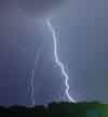 I set up the camera facing east out of the front living room window and
began taking pictures. Since it was nighttime, the exposures could be
long. Immediately, two cloud-to-ground flashes from another cell to the
east took up the first few frames. Finally, the storm to the west
arrived. A close strike behind me illuminated the hills,
immediately followed by a sudden crash of thunder. Another bolt struck
behind me, this one even closer. Finally, the lightning activity moved in
front of me. A flash hit the ground behind the hill, obscured by trees,
about 3/4 mile away,
barely captured on film on the far right side of the camera frame.
I set up the camera facing east out of the front living room window and
began taking pictures. Since it was nighttime, the exposures could be
long. Immediately, two cloud-to-ground flashes from another cell to the
east took up the first few frames. Finally, the storm to the west
arrived. A close strike behind me illuminated the hills,
immediately followed by a sudden crash of thunder. Another bolt struck
behind me, this one even closer. Finally, the lightning activity moved in
front of me. A flash hit the ground behind the hill, obscured by trees,
about 3/4 mile away,
barely captured on film on the far right side of the camera frame.
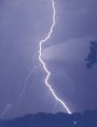
 Only 30 seconds later and 15 seconds into the next exposure, a bright,
blue-white lightning channel exploded in front of me, followed almost
instantly by a
deafening bang. I could tell it had hit the hillside less than 1/4 mile
away. Needless to say, I was pleased!
Only 30 seconds later and 15 seconds into the next exposure, a bright,
blue-white lightning channel exploded in front of me, followed almost
instantly by a
deafening bang. I could tell it had hit the hillside less than 1/4 mile
away. Needless to say, I was pleased!
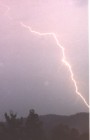
The next day I had the film developed. The photo revealed that the close
lightning flash hit a
tall tree on the hill, traveled halfway down the trunk, then jumped over
to a nearby house. I later discovered that the house was that of the
people who had just moved out of MY house! The lightning had destroyed
their large-screen TV, tripped 2 circuit breakers, and put all the
telephones out of commission.
This photo was printed on the front page of the Charleston Gazette, the local newspaper, the next day.
See the above photo in the Photo
Gallery.
That storm system was only the first of several systems that moved through
the Charleston area this week, driven by warm, humid unstable air.
First major storm system moves through area
April 10, 1998
I'm not a morning person. But, with a small dose of adrenaline, I can get
moving pretty quickly. Such a dose came Wednesday morning at about 6:30
A.M. as the first of a day-long episode of thunderstorms moved through
Charleston. As soon as my semi-conscious brain recognized the flashes of
lightning and distant thunder outside, I was awake, dressed, and outside
within minutes.
Here in the mountains, an oncoming storm with cloud-to-ground lightning
has a distinctive sound- one I could recognize even half asleep: An eerie
quiet is followed by a burst of light that paints the hills with a yellow
tint- followed by a short, resonating roll of thunder that echos through
the valley. It won't be long until the lightning activity moves over
the mountain and the first stroke crashes into the valley with an
earsplitting crack- hopefully while I have my shutter open!
My camera was not ready for the lightning that morning. Still half-groggy
from a brief
night's sleep, I fumbled to load the film and set up the tripod in the
faint light of dawn, while
intently watching the storm's advance.
Finally the storm was close enough to see the tops of the lightning
channels over the mountain. But the storm was going to pass to the east.
The lightning moved on northward, the channels barely visible in a shroud
of
rain. Besides, it was now past dawn, and the sky was getting
brighter by the minute. Oh well...at least my camera's
ready for the next storm!
The rain continued all day and through the night, with the occasional
intracloud flash now and then. Although the storms were mild in W.Va.,
many disastrous tornadoes touched down in the south from the same weather
system. (See this story in the Charleston Gazette)
Rare storms move through W.Va.
January 10, 1998
January in West Virginia: snowy mountains, houses with smoking
chimneys up the 'hollers', heavy winter coats, lightning, storms,
tornados....
What's that again?
At this time of year most kids in Murphytown and Moundsville would be
trying out their new sleds they got
for Christmas on a fresh snowfall that got school cancelled for three days.
Instead, they're cleaning up after two tornadoes that ripped through
their areas on Friday night (January 9, 1998).
A tornado in West Virginia? That's rare. Two of them? That's even more
unusual. In January? .....Yes, the pigs here are enjoying a new
activity- aviation.
Although those two towns are about 70 (or more) miles from Charleston,
our city didn't miss out on some rare winter lightning. The northward-moving
storms moved through Charleston between 10:30 P.M. and 11:30 P.M., giving
us a display of intracloud lightning. (The tornadoes touched down later on
that evening).
The storms capped off almost a week of unusually warm weather in our area.
Tornadoes in West Virginia in January? I'm wondering what June will be
like....
* Lightning Season 1997
* Lightning Season 1999
* Back Home
GO: Home | Storm Chase Logs | Photography | Extreme Weather Library | Stock Footage | Blog
Featured Weather Library Article:
|


