 April 2, 2006 chase - Missouri/Illinois April 2, 2006 chase - Missouri/Illinois
HD EXPEDITION VIDEO: Strong rotation in shelf cloud, 60mph winds
On Sunday, I left St. Charles (western St. Louis metro) at noon heading north on 61 toward Hannibal. Revising my original target of I-55 between STL and Cape Girardeau, I chose to instead jump on the area of strong isolation close to the surface low in northern MO, where I felt the best backed surface flow/heating combination would be. As the storms fired and quickly trended linear in north central MO, I waited west of Hannibal for a while, hoping that the line would break up as it encountered increasingly southeastery surface winds. A second area of convection fired ahead and south of this line, and I decided to move east into IL along 72 to wait for these to cross the highway. As I did, new convection fired just to my east with a few narrow, corkscrewing towers becoming evident. Born out of this new activity was an isolated cell just north of 72 in Adams County, IL. With no southern competition and well into backed surface winds, I latched on to the storm feeling that it held the best potential. I easily kept up with it, stairstepping my way NE in Pike County. Despite a few brief attempts at meager organization, the storm just couldn't get it done. I broke off at Meridosia (where I stopped to chat with Mark Sefreid, Scott Kampas and crew) and headed back down to 72 at Jacksonville to intercept a better-looking cell to our south.
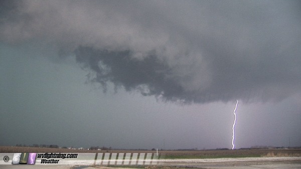
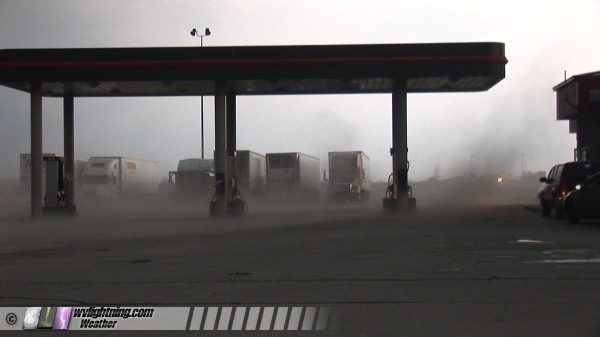
At Jacksonville, I watched the tornado-warned cell cross 72 with no apparent features other than an impressive developing shelf cloud racing east. I moved east ahead of this feature, barely staying ahead enough to stop for a few brief shots. I decided that the tornado potential with this line was becoming too random to continue pursuing, so I moved way ahead of the line to find a shelter to watch the hail as it passed over. I stopped at a gas station along 72 at New Berlin to watch the show. Sirens were sounding in the town, and a police cruiser screamed up to the gas station, the officer shouting for everyone to take cover. A persistent, strongly rotating cloud mass came at me from the west, attached to the shelf cloud. The video of this is impressive. No associated ground circulation/gustnado with this that I could see. This was as close as you get to a rotating wall cloud without it actually being that. This feature drifted just to my north as the shelf passed over.
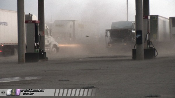
About a minute later, the gust front slammed me with 50 to 60mph winds, creating a wall of dust/small debris and rocking the pump canopy, signs and semitrailers in the parking lot. We lost power quickly. A trash can came sailing all the way across the large field to the west. I observed only a 30-second period of dime-sized hail.
Before I left to head to Springfield (hoping to find a tall broadcast tower for stratiform lightning photography), I discovered my right rear tire was completely flat from an unknown puncture in the parking lot. Using cans of fix-a-flat from the gas station (with cash registers on backup power) I was back on the road quickly.
This delay allowed the majority of the stratiform region to race away to the east. I briefly gave chase to the east, but got distracted by the massive amount of tornado damage and debris still present in west Springfield. Seeing a few new storms popping up at the back edge of the stratiform precip in the spectacular golden-pink sunset, I decided to go back east to watch these for a while before heading back to STL.
I should have stayed with my original target, but in retrospect I can't see myself making a different decision based on the info and data I had at the time. Overall a fun day with some new chase territory to add to the trip logs.
GO: Home | Storm Chase Logs | Photography | Extreme Weather Library | Stock Footage | Blog
Featured Weather Library Article:
|


