|
Home | Blog Index | Blog Archives | Christianity & Faith Essays | Storm Chasing Essays
Storm day possible today - Piedmont Triad NC
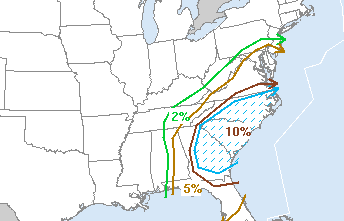
The new Day 1 is out - no moderate risk (yet), but a 10% hatched tornado risk is within easy range:
Some truly juicy parameters are shaping up for tomorrow across North Carolina. The GFS is in general agreement with the NAM/WRF, so I won't duplicate it in this discussion. This trough would be beckoning storm chasers worldwide if this was over Oklahoma in May:
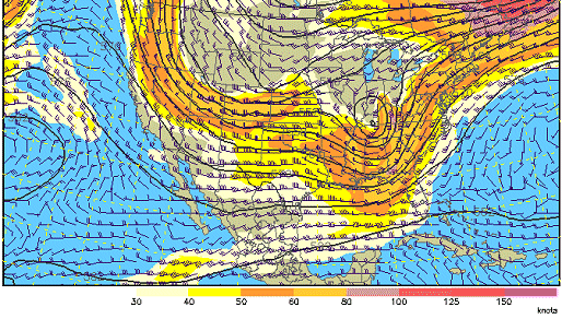
NAM/WRF 500bm wind forecast for 7PM Tuesday
All of this overtop of backed and fairly potent surface winds, with the enhanced vorticity of a low center close by:
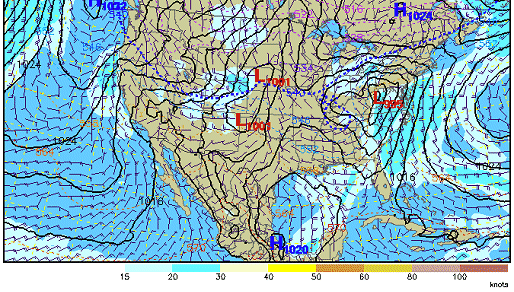
NAM/WRF surface forecast for 7PM Tuesday
As well as good moisture:
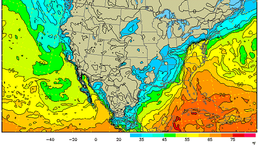
NAM/WRF dewpoint forecast for 7PM Tuesday
The negative of this setup will likely be instability-limiting cloud cover and precip, which was a factor in preventing a major outbreak down south on Monday.
It's hard to ignore conditions like that this close to home. The tornado risk extends from the coast all the way to the eastern edge of the Appalachians - making the I-40 corridor an ideal intercept highway. Both models indicate some activity ahead of the line by early afternoon, with the main squall line beginning its march eastward at Winston-Salem by sunset. It looks like Raleigh won't see the action until around midnight. The daytime tornado threat seems to be centered in the Triad area, so based on the current data, my preliminary target would be Mount Airy, NC by noon tomorrow. I'm not 100% certain I'm going to jump on this, but if I do, I'll be staying in Charleston until at least early tomorrow morning to refine the target.
|


