Storm Highway by Dan Robinson
Weather, photography and the open roadClick for an important message
Storm Highway by Dan RobinsonClick for an important message
This page lists all of the posts for our 2008 Storm Chasing & Photography Expedition, listed in chronological order. To view the blog with recent posts listed first (in conventional blog format), click here.

Home | Blog Index | Blog Archives | Christianity & Faith Essays | Storm Chasing Essays

                   Saturday, March 29, 2008 - 7:30AM

On the road westward2008 Event Blog Kickoff

By DAN ROBINSON
Editor/Photographer
Important Message 30 Years of Storm Chasing & Photography Dan's YouTube Video Channel Dan's Twitter feed Dan's RSS/XML feed

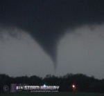
It's that time of year again! The 2008 spring storm season is coming alive - and that means it's time to start planning and preparing for the annual chase to 'Tornado Alley' during the peak severe weather season centered around late May. Some good chasing setups are already popping up out west, with Sunday and Monday both looking like potential tornado outbreak days over Texas, Oklahoma, Kansas and Missouri.

2008 Challenges

The 2008 storm season will be quite different for us this year. With gas prices threatening to top $4 a gallon during prime tornado season, this year's trip planning will be a little more challenging in the sense that financial factors will come into play almost as much as model data will. Consequently I will have to keep the criteria for chaseable events much more stringent than last season. Our team this year is also in an undetermined state, with several of us still working out details in scheduling flexibility.

Furthermore, since I first drafted this post in my blog queue a couple of weeks ago, unexpectedly high business taxes have dried up my entire funding for a 2008 Plains storm chase expedition - putting the trip in even greater jeopardy. Adding to the complication is the fact that my car (a 2005 Ford Freestyle) has over 130,000 miles on it. This puts it in the mileage range that the chances of a major mechanical issue during the trip (transmission, engine) start becoming a reality to consider. So not only will our basic trip expenses (gas & hotels) need to be funded, but I'll need to have enough to cover a major repair if one is needed.

There may be some possibilities to restore the travel budget later on next month, so I haven't given up on this year's chase 100%. The fact that I went ahead and published this post illustrates that - although I'll admit that things don't look good for a Great Plains trip right now. I debated whether or not to even mention the chase at all in light of the recent developments - but I figure that showing the typical hurdles encountered in making this trip happen every year will help put things in perspective, even if it ends up that we have to miss this year's season altogether. There is still at least a month and a half before peak season, so there is time for new developments. We'll see what the Lord wills. Based on my experience with Him, I can be rest assured in the fact that whatever happens will work out for the best.

Kansas tornado during Event 20072008 Blog Format

The 2008 Plains trip blog format will be the same as last year, with the posts related to the chase being 'grafted' in with the rest of the Storm Highway storm season blog. All posts relating to the chase will appear in this specially designed frame, making the separation from the normal posts a little easier.

What's Ahead

The annual Raleigh, NC chase vehicle clean-out and configuration will also be coming up sometime during the month of April. Since last spring's tripod compartment and wiring/console reconfiguration has worked great and held up well throughout the past year, there may not be as much to do other than to give the vehicle interior a good scrubbing. Some minor items such as dashcam mount tweaking, storage issues and wire tidying are also on the agenda.

Departure Date Probability

As with previous years, I'll be revisiting the departure date probability forecast excercise, with which I'll try to visually depict the thoughts on which dates look the best for heading westward. The departure date probability will be largely based on long-range forecast models that we use to watch for the hints of an upcoming severe weather pattern. But as I mentioned before, cost will also have to be factored in to this season's trips - even more so after the recent expenditures cutting into the travel budget.

At this point, we are way out of range of even the most far-reaching forecast models for May 1 and beyond, meaning that all dates during the 'standby period' currently have an equal chance of being the time that a trip will take place. The changes you'll see in this year's probability table reflect the better chance that a trip may not happen at all if good enough setups don't materialize. So, without further adieu, here's the first 'official' departure probability table for Storm Chasing & Photography Expedition 2008:

Based on the current outlook, this probability table charts the chance of our trip starting on a particular date:

2008 Storm Chasing & Photography Expedition - Departure Date Probability as of March 29
May 1-107%
May 11-207%
May 21-317%
June 1-157%
No trip72%

Home | Blog Index | Blog Archives | Christianity & Faith Essays | Storm Chasing Essays

                   Thursday, April 17, 2008 - 11:07AM

Raleigh vehicle clean-out and reconfiguration

By DAN ROBINSON
Editor/Photographer
Important Message 30 Years of Storm Chasing & Photography Dan's YouTube Video Channel Dan's Twitter feed Dan's RSS/XML feed

Click for larger version

Click for larger version

(Fisheye lens photos on this post by Matt Robinson) The weather in Raleigh has become perfect for chase vehicle work - and we haven't let that opportunity pass by. Yesterday afternoon, I started the process of removing everything from the car for its annual clean-out and tweaking in preparation for the upcoming storm season. If you're new to the blog this year, the reason the Raleigh house is optimal for this is the one-acre yard on the semi-rural outskirts of town. This provides a large, flat and safe space where multiple cars can be parked, opened up and worked on for days. This is in contrast to my options in Charleston, which would involve trying to do everything while parked on the side of a city street.

While we had the cleaning supplies, shop vacs and steam cleaner out, Matt and his wife Beth joined in on the process with their cars. I've been thinking that this would be a good basis for a pre-season observer cookout, where everyone brings tools and an extra set of hands to help get vehicles ready for the season. There was a storm chaser group in Indiana that had events like this several years ago, and I always thought it was a good idea. Maybe I'll look into planning something for next season.

Click for larger version

The main accomplishment yesterday was getting the car vacuumed and the interior wiped down, followed by the re-running and bundling of the front wiring for the laptop and USB devices. The rear cables leading to the power console need sprucing up, but since there are still questions about what devices will be going in there in the next two days, that process will likely hold off until tomorrow when some new equipment arrives.

Cellular router and console

The shipment of my Cradlepoint aircard router and external cellular antenna should arrive around midday Friday. At that point, the task will be building the console on which the aircard, the router, the voice-over-IP box and a telephone will be mounted. This portable 'access point' will be designed to fit in the car, while being easily removed to carry indoors for home and office use. The access point console is the biggest project of the week and the most significant addition to the chase vehicle technology. With it, I will have full internet access via WIFI and VOIP telephone service virtually everywhere I go.

Chasecam config update

The live chase camera will be running in one of two different modes this season, with a different configuration needed for each. The 'static image mode' is the one I plan to use most of the time. In static mode, the chase cam image will be captured once every 30 to 60 seconds and FTPed to the web server (just like the current webcams have been running). The Alltel connection has no problem with doing this, and since it uses very little processing resources on the computer side, will be run on the old Dell laptop along with the WxWorx software. For 'streaming mode', the camera will need to be plugged into the new HP dual-core laptop. Even if streaming works well (I haven't been able to test it yet), I don't plan to do it that often, as I don't want to put excessive strain on the laptops and the aircard connection. I will likely only stream on big storm chase days, and then only during the storm interception portion of the chase. Otherwise, the camera will run in static image mode.

Event chase forecast

Models show a developing large western US upper trough beginning to affect the Plains next week. Moisture quality in the Plains is very poor currently, but in the next few days should slowly return to favorable levels for severe storms. While none of the days next week look like major tornado outbreaks, they do look like the types of setups that will produce one or two good isolated supercells that may be very observer-friendly. Regardless of this, I don't see how we'll be able to leave before May 1 due to work schedules and my still-recovering storm chase expedition budget. Due to logistical and financial reasons, I expect that any storm chase expedition will need to wait until at least after May 10 or so. As always, that can change.

Based on the current outlook, this probability table charts the chance of our trip starting on a particular date:

2008 Storm Chasing & Photography Expedition - Departure Date Probability as of April 17
May 1-107%
May 11-2011%
May 21-3111%
June 1-1511%
No trip60%

Home | Blog Index | Blog Archives | Christianity & Faith Essays | Storm Chasing Essays

                   Monday, April 21, 2008 - 2:27AM

Preparing for a sidelined season

By DAN ROBINSON
Editor/Photographer
Important Message 30 Years of Storm Chasing & Photography Dan's YouTube Video Channel Dan's Twitter feed Dan's RSS/XML feed

My optimism for a Plains storm chase expedition happening this year was already on the way out even before the viewfinder on my Sony FX1 flickered Sunday evening, then started showing what looked like a scrambled cable TV channel picture. On top of everything else - my tax-obliterated travel funds, skyrocketing gas prices, no concrete team commitments, a high-mileage vehicle, slow sales in March and April, a business in need of attention and now critical equipment in need of a major repair are just not surmountable obstacles before spring is over. In the midst of the 'perfect storm' of circumstances in both their magnitude and timing, I have worked to find a way to make things happen this year, but all options are coming up short. Some things just aren't meant to be - fighting against it not only doesn't make a difference, but just makes the inevitable harder to accept. Strangely enough, resigning to the impossibility of this year's trip actually comes as a bit of a relief.

I believe that everything works out for good not only because the Scriptures say so, but because I've seen it happen before. Taking a look at past year's intercepts leaves me with no justification to sulk about this season. I've been blessed with more that I'd ever imagined, so I can manage a year off. So with that sentiment, I'm officially letting the 2008 Great Plains season go. The nice thing about getting older is how days, weeks and months get shorter every year - and spring of 2009 will be here quickly enough.

So with that, we'll officially 'sign off' on the chase blog until April of next year.

Based on the current outlook, this probability table charts the chance of our trip starting on a particular date:

2008 Storm Chasing & Photography Expedition - Departure Date Probability as of April 21
April-June1%
No trip99%

Home | Blog Index | Blog Archives | Christianity & Faith Essays | Storm Chasing Essays

                   Friday, April 25, 2008 - 10:46AM

Back in the game

By DAN ROBINSON
Editor/Photographer
Important Message 30 Years of Storm Chasing & Photography Dan's YouTube Video Channel Dan's Twitter feed Dan's RSS/XML feed

Storm Chasing & Photography Guide Services

LINK: Storm Chasing & Photography Guide Services

With every problem comes an eventual solution. I've been considering doing this for several years, but for some reason never decided to move on it until now. I've received many emails over the years asking about this type of service, but the 'light bulb' never really came on until this week. If this works out, storm chase expeditions to the Plains will be a regular thing!

So give this a look - and if you've got that friend who's always wanted to go tornado chasing (or if you're that person yourself), pass the word along!

Based on the current outlook, this probability table charts the chance of our trip starting on a particular date:

2008 Storm Chasing & Photography Expedition - Departure Date Probability as of April 25
April-June50%
No trip50%

Good call Dan, wish I lived in WV would def take you up on that offer !!!!
- Posted by Mick from United Kingdom

Thanks Mick, I'm looking forward to see how this works out. I may have launched things too late for this season, but we'll see what happens!
- Posted by Dan R. from Raleigh, NC

Home | Blog Index | Blog Archives | Christianity & Faith Essays | Storm Chasing Essays

                   Sunday, May 4, 2008 - 3:20PM

Greensburg anniversary, 2-week forecast

By DAN ROBINSON
Editor/Photographer
Important Message 30 Years of Storm Chasing & Photography Dan's YouTube Video Channel Dan's Twitter feed Dan's RSS/XML feed

Storm Chasing & Photography Guide ServicesExactly one year ago at this time (around 3PM CDT or so), I was driving eastbound on Highway 54 through the town of Greensburg, Kansas, on my way to a small area of surface convergence / cumulus that had popped up west of Wichita. I don't remember much about my short few minutes breezing through there, as with most of the hundred or so small Plains towns I've seen. Of course I had no idea of what was to happen about 5 hours later. I wish now I had least snapped a photo of something in the town (like the 'Big Well' water tower), as I normally do when I see an interesting landmark along the road.

So on to the outlook for the next 2 weeks. The GFS has flipped around on its mid-month Hudson Bay vortex forecast, and is now showing a large western trough moving into the Plains around a week from this Wednesday. That's as dramatic a change as you can get, which as you should know by now, is no surprise with a long-range model. The big trough has been there, in some form, for the past 4 consecutive runs now - lending some credibility to the forecast.


GFS 500mb forecast for May 15

With us now entering the heart of the Plains tornado season, such an upper-level pattern will likely have ample low-level cooperation with moisture, lift and winds near the surface - in other words, a pattern that means 'time to go chasing'.

Based on the current outlook, this probability table charts the chance of our trip starting on a particular date:

2008 Storm Chasing & Photography Expedition - Departure Date Probability as of May 4
May 9-2530%
May 26-June 1550%
No trip20%

Home | Blog Index | Blog Archives | Christianity & Faith Essays | Storm Chasing Essays

                   Tuesday, May 6, 2008 - 1:58PM

No help from the models

By DAN ROBINSON
Editor/Photographer
Important Message 30 Years of Storm Chasing & Photography Dan's YouTube Video Channel Dan's Twitter feed Dan's RSS/XML feed

Storm Chasing & Photography Guide ServicesAnd down the next hill on the roller coaster. The long-range models really have been doing poorly so far this month, to the point that they are nearly useless. Most would say they are useless anyway - but at least some of the time you can glean a large-scale pattern hint from them if they are consistent. No such consistency exists now, leaving the next two weeks a total guessing game. Here is the latest flip-flop from the GFS, showing a dismal pattern for most of the USA by mid-week next week:


GFS 500mb forecast for May 16

The good news is that I've figured out a way to all but ensure at least one 2 to 4 day storm chase expedition to the Plains this season (barring any big surprises). However, my forecast criteria for embarking on a chase will be very strict. Only a multi-day setup with strong, surefire parameters all around (upper air, surface moisture, low-level winds) will get my attention. Any setup with just one critical ingredient in question will not get my green light. I'm looking for patterns like May 3-10 in 2003; May 21-29 in 2004; June 10-12 in 2004; June 7-12 in 2005 or May 4-5 in 2007 - setups that produced tightly clustered tornado events (in time) that had little question of the right ingredients coming together. Typically we get at least one of those every storm season, but sometimes (like in 2002 and 2006) there are none to be seen. The latest update to the probability table reflects this higher criteria standard, as well as the forecast uncertainty (thanks to the models' performance lately).

Based on the current outlook, this probability table charts the chance of our trip starting on a particular date:

2008 Storm Chasing & Photography Expedition - Departure Date Probability as of May 6
May 9-2520%
May 26-June 1540%
No trip40%

Home | Blog Index | Blog Archives | Christianity & Faith Essays | Storm Chasing Essays

                   Thursday, May 8, 2008 - 1:35AM

Hard times for storm chasers

By DAN ROBINSON
Editor/Photographer
Important Message 30 Years of Storm Chasing & Photography Dan's YouTube Video Channel Dan's Twitter feed Dan's RSS/XML feed

Storm Chasing & Photography Guide ServicesUp to this point, spring 2008 has not been going too well for storm chasers. So far this season, most of the promising setups have been either major disappointments, or outside of the Plains altogether. Aside from a half-decent trough showing up early next week (which actually looks too far south right now to be of much consequence), the models keep painting an uninteresting picture for the next couple of weeks.

And as if hail dents, long drives, high gas prices and uncooperative weather patterns weren't enough, it looks like storm chasers have a new hazard to watch out for this year: getting arrested! storm chasers in general (and photographers/cameramen too for that matter) have been seeing an increase in hostility by a few rogue law enforcement entities in recent years - partly due to the post-September 11 climate, but more often than not due to irrational overzealousness on the part of specific officers. Granted, there are a few bad apples in our own ranks that don't help things for us (reckless drivers, traffic-blockers and post-tornado devastation gawkers). But this latest incident (involving a storm chaser being ordered to move from a parking spot in a rest area while they observed a storm) shows that the worst can happen to any of us. I guess the only thing we can do is keep our cameras rolling at all times, so a full record of everything that happens before, during and after can be our advocates in court. That's partly the reason why I run a full-time dashcam in my car, whether I'm observing or not.

So back to the upcoming pattern. Things look plenty unsettled as the jet stream wiggles around in mid-country, but no major troughs mean that a nice, organized easy-to-intercept system is not on tap for storm chasers. Even here in Charleston, the large-scale upper pattern will be supporting little more than cloudy skies, cool temps and off-and-on rain for at least a week. It's going to be a good time to work inside and get a few things done - which is usually a blessing in disguise. Again, we are still very early in the peak season, which runs through about mid-June - so there is plenty of time for things to change. At this stage, I don't see a trip happening until at least the 18th.

Based on the current outlook, this probability table charts the chance of our trip starting on a particular date:

2008 Storm Chasing & Photography Expedition - Departure Date Probability as of May 8
May 9-1810%
May 19-3125%
June 1-1525%
No trip40%

Home | Blog Index | Blog Archives | Christianity & Faith Essays | Storm Chasing Essays

                   Saturday, May 10, 2008 - 10:49AM

Tornado outbreaks this weekend - outside of the Plains!

By DAN ROBINSON
Editor/Photographer
Important Message 30 Years of Storm Chasing & Photography Dan's YouTube Video Channel Dan's Twitter feed Dan's RSS/XML feed


SPC severe storm risk (left) and tornado risk (right) for Saturday

Storm Chasing & Photography Guide ServicesThe first true 'big' tornado event of the spring 2008 season looks to commence today and continue into tomorrow - but only a sliver of it within the traditional 'tornado alley'. The mid-Mississippi valley and southern US states instead will be under the gun, something that has been common so far this year. Today's pattern favors a significant tornado outbreak from Arkansas to the Gulf Coast, with strong upper-level winds and deep moisture at the surface. The outbreak should move into the southeast states of Georgia and Alabama on Sunday as the system moves offshore into the Atlantic.

The setup looks great and the chances of seeing tornadoes are fairly high - but I decided to sit this event out. First of all, I would have needed to make the call to go no later than yesterday afternoon, in order to make it in time. I hesitated too long to make the 15-hour drive to the AR/OK border. Second, while this may turn out to be a two-day event across the south, its wide footprint between the two days means that one would likely not be able to cover both days (with sufficient sleep in between) due to the long distances between them. I figured a probable path that I would have ended up taking would have been starting in western Arkansas along I-40 this morning, then working my way eastward through Memphis and ending up in Nashville, TN or Birmingham, AL. From there, I may have had time for 3 or 4 hours of sleep before trucking on to Georgia for Day 2, then ending up in Raleigh to round out the trip. That would end up being over 3,000 miles total - and at 400 miles per tank of gas, that would end up being a $550 fuel expense.

Now I'm an advocate of chasing outside of the Great Plains, because success can be had wherever a good setup materializes. But I've only got funding to make one solo trip this year, so I have to choose wisely. While there will be chaseable tornadoes this weekend, my budget dictates a choice to wait for another setup in better territory.

The models have seemed to line up in agreement of a big east coast trough forming later next week, after another round of southern US severe weather events. So, it's looking like any trip will be at least well into the later half of the month.

Based on the current outlook, this probability table charts the chance of our trip starting on a particular date:

2008 Storm Chasing & Photography Expedition - Departure Date Probability as of May 10
May 10-2515%
May 26-June 1540%
No trip45%

I can't wait to see how it unfolds. My weather is going to be in alert mode all night long.
- Posted by Cholivan from Owensboro, KY

In my amateuer mode I say good call Dan, thinking of your chase budget, early days still yet !
- Posted by Mick from United Kingdom

So far I'm glad I stayed home - looks like a mess out there now where I would have targeted (central Arkansas). There have been a few tornadoes in there, but from the looks of radar and the storm reports so far, it is not yet the big outbreak that was expected. The storm of the day so far looks like the SE Kansas/SW Missouri supercell that has produced a series of strong tornadoes. It's still early, but only a couple of hours of daylight left out there, and no sign of things really getting going anytime soon. In fact a lot of the storms look to be weakening now.
- Posted by Dan R. from Charleston, WV

Home | Blog Index | Blog Archives | Christianity & Faith Essays | Storm Chasing Essays

                   Monday, May 12, 2008 - 11:10AM

Another 2006 in the works?

By DAN ROBINSON
Editor/Photographer
Important Message 30 Years of Storm Chasing & Photography Dan's YouTube Video Channel Dan's Twitter feed Dan's RSS/XML feed


GFS 500mb forecast for May 19

Storm Chasing & Photography Guide ServicesThe Plains severe weather machine shuts down for a good period beginning next week, as the upper air pattern depicted above takes hold of the country. Good moisture gets shoved deep into the Gulf, far, far away from the prime chase terrain. It's a picture reminiscent of 2006, when even the return of a good upper air pattern couldn't overcome the meager moisture quality (resulting from the previous trough's scouring of the surface). In the short term, a trough looks to be moving through the extreme southern US, bringing chances for severe weather to the Gulf coast regions (and possibly a little further north) - far from an ideal observing setup, and more like a December pattern than a May one. Looking at the long-range models, a decent but fast-moving trough develops toward the end of next week. It doesn't look big enough at this point to make a storm chase expedition worth the money, though - and that's even if moisture can get back in place in time. Other than that, the pattern looks pretty bland for the foreseeable future.

The 2008 season is already leaving a sour taste in my mouth as a storm chaser. Not only have the classic slow-moving, photogenic storms of the Plains' remote country failed to materialize - where the tornadoes have happened, they've wreaked death and destruction on par with some of the worst-casualty seasons in recent memory. Saturday's northeast Oklahoma / southwest Missouri supercell alone has already claimed twice as many lives as the Greensburg EF5 tornado did last year.

As for my chase plans, I admit I'm not too motivated at this point to spend the $1,000 to $2,000 that it will take to make a chase happen. If I had decided to chase any of this season's setups so far, they would have resulted in miserable, expensive busts. Now I know that you have to be willing to accept failure in chasing to get to the successes, as it's just part of the game. Not even the best storm chasers see tornadoes every time they go out. But at this stage I'm not as willing to accept the potential of a costly chase with no returns. When I got gas yesterday, seeing midgrade now over $4 really hit home as to how much it's going to take.

Furthermore, I've been giving thoughts to spending my Plains trip budget on a new DSLR instead, and 'returning to my roots' as a storm chaser by getting back into shooting lightning stills. There is plenty of that around WV and into Ohio, Kentucky, North Carolina and Pennsylvania - and it would be nice to have this relaxing and less expensive subject to focus on again. So doing that, while leaving any Plains trip funding entirely up to my tour business, is looking more and more attractive to me.

Based on the current outlook, this probability table charts the chance of our trip starting on a particular date:

2008 Storm Chasing & Photography Expedition - Departure Date Probability as of May 12
May 9-255%
May 26-June 1535%
No trip60%

Home | Blog Index | Blog Archives | Christianity & Faith Essays | Storm Chasing Essays

                   Thursday, May 15, 2008 - 10:20AM

A tale of two models

By DAN ROBINSON
Editor/Photographer
Important Message 30 Years of Storm Chasing & Photography Dan's YouTube Video Channel Dan's Twitter feed Dan's RSS/XML feed


GFS 500mb forecast for May 25

Storm Chasing & Photography Guide ServicesTwo popular long-range forecast models I watch with regularity are the GFS and the ECMWF (the 'European' model), both with output to ten days (the GFS goes out to 14). As you've heard me say a million times, long range models are notoriously erratic the farther out you go, so much so that some meteorologists and storm chasers refuse to even look at them. However, if the same pattern forecast shows up over and over again each time the model is run, this consistency indicates a better probability that the forecast may actually have a chance of happening. Now - once a model is consistent over a period of days, then you compare its output to a 'competing' model. If they are in even slight agreement, then you've got an even more confident forecast (relatively speaking, as you'll rarely use the word 'confident' in any discussion of long-range forecasts).

The past few days, both the GFS and the ECMWF have been remarkably consistent in their forecasts. That's good, right? Well normally yes, but not this time - for late next week, they are (consistently) forecasting completely opposite patterns for the continental US - something I haven't seen in the time I've been observing! The GFS wants to shut down the 2008 storm season, keeping a huge eastern trough and northwesterly flow over the Plains. The ECMWF, however, wants to bring a week of dream storm chase days, placing a huge western trough in a place that will ensure tornadoes happening daily somewhere in the central US.

When models are so consistent and yet so diametrically opposed to each other, there is little that a storm chaser can do but just wait. Eventually, one of the models will concede to the other's pattern. So which one win the battle this time? The European model is the favored one in situations like these, but such a strong signal on the GFS for the opposite to happen can't be ignored.

As for my chase plans - as you've seen, the DSLR won out this week over a trip. That will do it for my Plains chasing budget this spring, and therefore also my plans for a chase. The tour option is still open - and therefore I'll still leave that possibility reflected in the departure probabilities.

Based on the current outlook, this probability table charts the chance of our trip starting on a particular date:

2008 Storm Chasing & Photography Expedition - Departure Date Probability as of May 15
May 9-252%
May 26-June 158%
No trip90%

Home | Blog Index | Blog Archives | Christianity & Faith Essays | Storm Chasing Essays

                   Friday, May 16, 2008 - 12:23AM

A light at the end of the eastern trough?

By DAN ROBINSON
Editor/Photographer
Important Message 30 Years of Storm Chasing & Photography Dan's YouTube Video Channel Dan's Twitter feed Dan's RSS/XML feed


GFS 500mb forecast for May 24

Storm Chasing & Photography Guide ServicesTo the joy of storm chasers across the Plains, the GFS model is finally starting to show signs of losing its argument with the ECMWF model. The European model continues to be steadfast about the return of a western trough and a good observing pattern starting next week. It's still too early to get too overly excited, but the signs so far have been encouraging.

Based on the current outlook, this probability table charts the chance of our trip starting on a particular date:

2008 Storm Chasing & Photography Expedition - Departure Date Probability as of May 16
May 9-2520%
May 26-June 1520%
No trip60%

Home | Blog Index | Blog Archives | Christianity & Faith Essays | Storm Chasing Essays

                   Saturday, May 17, 2008 - 1:52PM

Event chase next week!

By DAN ROBINSON
Editor/Photographer
Important Message 30 Years of Storm Chasing & Photography Dan's YouTube Video Channel Dan's Twitter feed Dan's RSS/XML feed

Wow! Talk about an unexpected turn of events. An opportunity has come up that will allow for a nearly certain chase expedition to the Great Plains starting Tuesday. I'll explain more in the coming days. The trip does hinge on the good observing pattern that is forecast by the models actually coming to pass in some form. If the models are off and the western trough / cutoff low totally tanks, the plans may change. If not, then I'll be on my way westbound heading for a starting point of Amarillo, Texas on Wednesday.

Based on the current outlook, this probability table charts the chance of our trip starting on a particular date:

2008 Storm Chasing & Photography Expedition - Departure Date Probability as of May 17
May 19-3095%
May 26-June 154%
No trip1%

I thought your spent your $$ on that new DSLR.
- Posted by Dan Cook

That I did - next week's trip is an all expenses paid gig!
- Posted by Dan R. from Charleston, WV

Got a tour eh?
- Posted by Doug & Bill

Nice one Dan, hope you have a good trip !! Will look forward to the posts, will you be taking the chase cam etc ?
- Posted by Mick from United Kingdom

Thanks! I won't be in my own vehicle and won't have a laptop desk with me this time (I'll be in a convoy and won't need to be monitoring data), so I'm not sure how feasible running the laptop and live camera will be. I'll see what I can do though, it would be nice to have it running.
- Posted by Dan R. from Charleston, WV

Home | Blog Index | Blog Archives | Christianity & Faith Essays | Storm Chasing Essays

                   Monday, May 19, 2008 - 1:49AM

Event trip on track, but with forecast issues

By DAN ROBINSON
Editor/Photographer
Important Message 30 Years of Storm Chasing & Photography Dan's YouTube Video Channel Dan's Twitter feed Dan's RSS/XML feed

My departure date probability table has been flip-flopping around almost as much as the GFS model, taking into account a tough tax year, a high-mileage vehicle and uncooperative weather patterns. But even in this season that I'd already written off, the Lord continues to provide opportunities and turn things around.

The current plan is I will be teaming up with a chase tour group as an assistant/driver on a week-long chase starting on Wednesday. We are scheduled to depart from Amarillo, Texas on the 21st, and as long as the Lord wills and the pattern cooperates, will continue observing through the middle of next week. I hope to be on the road westbound out of Charleston by mid-afternoon today, with a stopover somewhere west of St. Louis. The final 11 hours of the 19-hour drive will be completed on Tuesday, with an arrival in AMA by midnight.

The only caveat for this trip remains if the severe weather-favorable pattern completely vanishes, in which case the tour may be cancelled if the guests opt out. Unfortunately, Sunday night's model runs are certainly making me a little nervous. The problem with the upcoming system, at least according to model data, is that the main upper-level wind support of the huge western trough is going to be kept from moving east over the Plains. The culprit is the strong trough still sitting over us here in the eastern US, blocking the western trough from shifting east. The GFS forecast for Friday shows storms developing in the Plains, but with moisture too far east and the upper level support too far west:


GFS 500mb & dewpoint forecast for Friday evening

Without strong upper level winds, storms will have trouble with precipitation falling back through or close to their updrafts, with does not favor overall storm organization. In other words, high-precipitation (HP) supercells that, if they manage to produce tornadoes, will not lend themselves to photogenic intercepts. This is all a rather big disappointment considering the outbreak scenarios depicted by the ECMWF model, which up until the past day or so had been showing a massive western trough and a huge eastern ridge. Now the European model has started to take on a blend of its old western trough forecast and the GFS' original eastern trough forecast, keeping both in the picture to form a classic Omega Block over the US (not good for storm chasing).

And that's just one of the major concerns with this system. In addition to the separation of the surface moisture from upper level support, an ironclad convection-inhibiting capping inversion on Wednesday and Thursday may keep storms from firing at all. And beyond Friday, the upper trough may actually start retrograding back west over the Pacific coast, leaving the Plains in a 'death ridge' of high pressure. According to tonight's GFS, Friday looks to be the only good chance of anything chase-worthy. Without that upper trough bringing strong flow aloft over the moisture, supercells and tornadoes will be tough to come by. Without the tour arrangement (which covers the majority of my costs), this is not looking like a system I'd choose to chase under normal circumstances.

However, somewhat encouraging is the 00z run of the NAM/WRF, which kicks the trough out a little more over the Plains - giving any storms more upper support. The cap is still problematic, but not as strong as the GFS indicates. So early this afternoon will be the 'go' or 'no go' time, as by then the mid-day model runs will be out. At this point, all indications are that the trip is still on track - in which case I'll be westbound as soon as I confirm the tour guests are also on their way.

As usual during a chase, I will attempt to update the blog with photos, HD video and chase logs as often as I safely can - so stay tuned!

Based on the current outlook, this probability table charts the chance of our trip starting on a particular date:

2008 Storm Chasing & Photography Expedition - Departure Date Probability as of May 19
May 19-3090%
May 26-June 155%
No trip5%

Home | Blog Index | Blog Archives | Christianity & Faith Essays | Storm Chasing Essays

                   Monday, May 19, 2008 - 1:48PM

Westbound!

By DAN ROBINSON
Editor/Photographer
Important Message 30 Years of Storm Chasing & Photography Dan's YouTube Video Channel Dan's Twitter feed Dan's RSS/XML feed

The 12Z models look much better! Both the WRF/NAM and GFS push the upper trough a little farther east, nicely juxtaposing the strong upper-level winds with the good low-level winds and moisture at the surface. We're still several days out, so some further changes are not out of the question. Nonetheless, my tour guests are on their way, so we're observing this thing whatever it ends up doing. So I am out the door now and heading west! I'll have the ChaseCam running on and off periodically during the trip to Amarillo today and tomorrow.

2008 Storm Chasing & Photography Expedition - Departure Date Probability as of May 19
May 19-30100%
No trip0%

Home | Blog Index | Blog Archives | Christianity & Faith Essays | Storm Chasing Essays

                   Monday, May 19, 2008 - 6:29PM

Day 1: Charleston, WV to Springfield, MO

By DAN ROBINSON
Editor/Photographer
Important Message 30 Years of Storm Chasing & Photography Dan's YouTube Video Channel Dan's Twitter feed Dan's RSS/XML feed

Travel log for Day 1!

Update - 11:14PM CDT: St. Louis!


Click to enlarge

Just glanced at the 00z WRF/NAM model, and wow! Thursday looks like the outbreak that last week we thought might happen. The upper support is shown well into the Plains. We're deailing in model land, so we're not out of the woods yet.

Update - 6:29PM EDT: A quick post from overcast and lightly-raining Louisville. Fixed (hopefully) an issue with the live camera - the jpeg file sizes were too big, and the capturing software wouldn't update the image if the connection wasn't good. I lowered the compression settings so this shouldn't keep happening.


Click to enlarge


Click to enlarge

Home | Blog Index | Blog Archives | Christianity & Faith Essays | Storm Chasing Essays

                   Tuesday, May 20, 2008 - 1:53PM CDT

Day 2: Springfield, MO to Amarillo, TX

By DAN ROBINSON
Editor/Photographer
Important Message 30 Years of Storm Chasing & Photography Dan's YouTube Video Channel Dan's Twitter feed Dan's RSS/XML feed

Travel log for Day 2:

Update - 11:48PM CDT: Just a quick note to comment on the mobile internet situation. The Alltel aircard almost always has four bars of signal strength, but the performance of the internet data has really been disappointing. The connection was unusable from Joplin westward, with the exception of the bigger metro areas along I-40 in Oklahoma. West of OKC, the card showed I had data, but no connections worked (web/ftp/email) . Streaming is not going to happen, as I'm even having a hard time keeping a 12kb static jpeg uploading regularly.

So, it looks like the chasecam will be a lost cause for most of this trip. If data hardly works on the interstates out here, I don't expect it to work out in the middle of nowhere. storm chasers seem to be having good experiences with a cellular amplifier antenna, but the thing runs $350-$500! No way I'm dropping that much money into this system, since I'm only using it on the road. So it's back to the old tried-and-true Baron ThreatNet for this trip.

Speaking of cameras, it looks like both of the Charleston cameras went down at 9:25AM this morning - which points to a power outage. Since I'm not there to reset them, I'm taking them down from the feed list temporarily. I'll still be trying to eke out an updated image from the chasecam when I can, so I'll leave its feed up for now.

Update - 10:34PM CDT: Arrived and settled into the hotel here in west Amarillo! Grabbed a quick dusk shot downtown:


Click to enlarge

Earlier, anvil blowoff from storms 200 miles to the west put a stop to the sunset I hoped to get at Groom. The overall scene was still pretty good.


Click to enlarge

Welcome to Texas, the land of generous speed limits. Would you go 70 on this road?


Click to enlarge

Update - 4:56PM CDT: On course to make Amarillo around 9PM, unless I stop for very long to shoot the sunset (hopefully around Groom, TX), or even a storm if one can get going this evening (a very marginal risk exists). My target arrival time was 10PM, but I won't be hurting to get there a little later than that if needed. My self-imposed schedule was simply to ensure plenty of sleep, which it looks like I won't have any trouble with. Especially since tomorrow's target may end up being a few miles east of AMA! I just finished shooting for about an hour in OKC with a nice sky and full sun. Attempting to emulate some of my brother Matt's urban photography style here, though I've got a ways to go to approach his level. This set is a little long for this post, so it has its own page:


Click for photo set


Click for photo set

Update - 1:53PM CDT: Rolling through Tulsa now, trying to decide whether I want to take the scenic route to OKC or pay the $3.50 for the quicker trip down the Turner Turnpike.


Click to enlarge


Click to enlarge

Update - 8:50AM CDT: Still running about three to four hours ahead of schedule, which will allow for several more photography stops along the way today (exactly where, I'm undecided - but Tulsa and OKC are good possibilities).

The bad news about the pattern I'm driving through is that I'm crossing the high pressure ridge now, which will shut out virtually all chances of storms today. The good thing about it is that it will keep skies mostly clear and blue, perfect for a road trip. Lord willing, I'll get one of those classic western Oklahoma sunsets later today.

Home | Blog Index | Blog Archives | Christianity & Faith Essays | Storm Chasing Essays

                   Wednesday, May 21, 2008 - 1:06AM CDT

Amarillo lightning

By DAN ROBINSON
Editor/Photographer
Important Message 30 Years of Storm Chasing & Photography Dan's YouTube Video Channel Dan's Twitter feed Dan's RSS/XML feed

Well, here it is - the first one. This is why I love it out here. Sometimes things that aren't supposed to happen, happen anyway. What capping inversion :) This is from the hotel parking lot. I heard thunder, went out and took exactly one frame to get this, then went back inside (need to get to bed!). One file on the SD card, one lightning shot. Cooperative lightning is the greatest.


Click to enlarge

Hopefully more to come.

Today's severe weather risk is mainly up in Wyoming, but a setup also exists right here in the Texas Panhandle this afternoon. And so when the guests arrive later this morning, I expect we'll begin our first storm chase day of the trip somewhere very close to Amarillo. Tomorrow's target may end up being anywhere from southern Nebraska to Oklahoma. The pattern looks very good so far for storm chasers at least through Monday - so much so that unlike my previous asessment, if I wasn't here already on a tour, I'd probably would have been heading west out of Charleston by now under normal circumstances. That would put me arriving in the target area tomorrow just before things got going. It's kind of nice to not have that (more rushed) drive ahead of me now.

Without a good internet connection, I'm not sure how often I'll be able to post updates during the day, if at all. If our target tomorrow ends up being in the northern reaches of the setup (Nebraska) we may end up driving for a while before settling down for the night. At any rate, wherever and whenever we end up I'll try to get a few photos up.

Home | Blog Index | Blog Archives | Christianity & Faith Essays | Storm Chasing Essays

                   Wednesday, May 21, 2008 - 5:00PM CDT

Day 3: First storm chase day - TX, OK panhandles!

By DAN ROBINSON
Editor/Photographer
Important Message 30 Years of Storm Chasing & Photography Dan's YouTube Video Channel Dan's Twitter feed Dan's RSS/XML feed

Update - 10:33PM CDT: Today's sleeper setup never really woke up. Some nice lightning with today's cells around Amarillo, but with the bright daylight conditions, not much chance of capturing anything noteworthy. The lack of a big storm complex tonight, and subtle boundaries created by the weak storms, will bode well for tomorrow's prospects - which still look great! Signing off for tonight...

Update - 5:00PM CDT: Still hanging tight at the hotel here in Amarillo, eyeing the cumulus field to our west in New Mexico. Possibly heading that way in the next hour or two if it looks like it's going to fire. Looking like a late show today if anything, at least for daytime storms. When the low-level jet kicks in later tonight, we should get a good lightning barrage somewhere close to here.

11:51AM CDT: Looks like a sleeper day is in the making across the panhandles this afternoon. The tour guests will be arriving later tonight, so we'll be starting their chase tomorrow. That leaves me with a chase on my own for today.

Tornado threat appears minimal today with moisture still in recovery mode, though a supercell or two looks like a good bet. Should be a fun day to start things out, hopefully with some nice lightning and storm structure to give the cameras a workout!

Home | Blog Index | Blog Archives | Christianity & Faith Essays | Storm Chasing Essays

                   Thursday, May 22, 2008 - 8:31AM CDT

Day 4: Potential outbreak across Kansas, Oklahoma

By DAN ROBINSON
Editor/Photographer
Important Message 30 Years of Storm Chasing & Photography Dan's YouTube Video Channel Dan's Twitter feed Dan's RSS/XML feed

Update 10:38PM CDT: Played the higher CAPE target in the panhandles, and didn't see much. A disappointing day considering what was had up north on the I-70 corridor. Currently in Dodge City for the night, wondering if the models and the SPC are right about redevelopment over us overnight.

Some photos from the day:

"Shear funnel" south of Laverne, OK:


Click to enlarge

Struggling towers near Follett, TX:


Click to enlarge

First storm of the day near Booker, TX:


Click to enlarge

8:31AM CDT: Getting ready to leave Amarillo in a few minutes, heading northeast. Updates to this blog will probably become more sporadic due to the major storm chase days - but should be able to post quick updates at the start and end of each day.

GOOD LUCK AND STAY SAFE. I HOPE YOU SEE SOME GOOD STORMS AND GET SOME GREAT VIDEO. SALLY R
- Posted by SALLY R

Safe Driving and Fun Storm Chasing & Photography...
- Posted by Tom M

Looking forward to the results, have a great time Dan.
- Posted by Mick from United Kingdom

I'm visiting your website every day, thank you for great videos and photos. I hope you intercept great storms today. God bless you!
- Posted by L Lee from Arizona

Hey Dan - Good call today with the High Risk out there. Can't wait to see what you come up with! Spencer
- Posted by Spencer from Huntington

Thanks everyone, I appreciate the comments! We'll be here at least through Sunday, with several more good chances in the next few days.
- Posted by Dan R. from Dodge City, KS

Home | Blog Index | Blog Archives | Christianity & Faith Essays | Storm Chasing Essays

                   Friday, May 23, 2008 - 8:22PM CDT

Day 5: Another Kansas outbreak

By DAN ROBINSON
Editor/Photographer
Important Message 30 Years of Storm Chasing & Photography Dan's YouTube Video Channel Dan's Twitter feed Dan's RSS/XML feed

Update 8:22PM CDT: Back in Dodge City for the night. Another fruitless day. Heading back to Amarillo tomorrow to take our guests to their hotel, as they are flying home Sunday. I'll be starting the drive back to WV as soon as I have my car on Saturday, arriving home Sunday.

Update 3:10PM CDT: Heading west out of Dodge. Trying the live cam again, data seems to be working a little better in Kansas.

Update 2:03PM CDT: Cumulus field getting thicker outside - MD issued, getting ready to head out for the day!

12:01PM CDT: Liking our current location in Dodge City, and will be sitting here for at least another couple of hours. Possibly a repeat setup from yesterday, with even better moisture and upper support.

A storm may produce tornado near Colby, KS in an hour. I hope you catch non-damaging photogenic violent tornadoes. Good Luck!
- Posted by L Lee from Arizona

Dan - sorry it didn't pan out. Can you believe GREENSBURG AGAIN? Poor folks nearby! We'll be watching the blog to see where you are going next!
- Posted by Spencer from Huntington

Yeah - unreal that Greensburg is under the gun again. Storm Chasing & Photography with the tour has been different in that we've been conservative with positioning and driving, to avoid hail and strong winds. We did find 2.5 inch hail on a road that we allowed a storm to pass us by.
- Posted by Dan R. from Dodge City, KS

Pleanty of action in KS and OK yesterday, did you catch it?
- Posted by Ed

Home | Blog Index | Blog Archives | Christianity & Faith Essays | Storm Chasing Essays

                   Saturday, May 24, 2008 - 8:51PM CDT

Day 6: Going again - KS/OK

By DAN ROBINSON
Editor/Photographer
Important Message 30 Years of Storm Chasing & Photography Dan's YouTube Video Channel Dan's Twitter feed Dan's RSS/XML feed

Update 8:51PM CDT: Success in Oklahoma! Made a LONG haul to the Oklahoma tornado machine and bagged 2 on the ground at the same time. A small number considering the millions of tubes this thing put down before we got to it, but we're not empty-handed today! A couple of quick photos - more to come!


Click to enlarge


Click to enlarge


Click to enlarge

Currently on the road back to Amarillo tonight with two very happy tour guests. Maybe some lightning photography later tonight, if the models are correct.

11:34AM CDT: Trying again today in southern Kansas and northern Oklahoma. Setup is more conditional today there - no outbreak, but if a storm can go up it should have a chance at something. This will allow one more storm chase day before our guests have to fly out tomorrow.

The storm at west of Enid, OK become tornadic supercell. It's not a big day but I hope you catch tornadoes today. Good luck!
- Posted by L Lee from Arizona

Congratulation!! finally You made it! Good night and drive safe.
- Posted by L Lee from Arizona

Bingo !!! Well done Dan !
- Posted by Mick from United Kingdom

Congrats Dan! Nice shots. Hope we can meet up in Amarillo.
- Posted by Randy from O- City

good job dan.. talked to bill yesterday and he said you were on your way.. what a storm.. congrats on the catch.. nice job.. be safe!!!!
- Posted by Jesse Bass from Virginia

Home | Blog Index | Blog Archives | Christianity & Faith Essays | Storm Chasing Essays

                   Sunday, May 25, 2008 - 2:04PM CDT

Day 7: Western Kansas

By DAN ROBINSON
Editor/Photographer
Important Message 30 Years of Storm Chasing & Photography Dan's YouTube Video Channel Dan's Twitter feed Dan's RSS/XML feed

Update - 12:39AM CDT: Not much to report today. Targeted Garden City, Kansas, but ended up jumping on the Amarillo area cell. With little upper support, the storm was a huge outflow monster, producing little more than heavy rain and lightning during the time I observed it. From what I've heard, the Kansas targets didn't really produce much either. Spent the rest of the evening observing lightning around northwest Oklahoma, but with constant rain and high winds, that wasn't too fruitful. I did get a couple of OK shots. Currently at a hotel in Woodward. Tomorrow's risk was supposed to be in Kansas, but I wouldn't be surpised to see it moved southward closer to here, thanks to the outflow boundary from tonight's storms. We'll see in the morning... Here are a couple of shots from today:


Click to enlarge


Click to enlarge


Click to enlarge

2:04PM CDT: Currently near Laverne, OK heading up to western Kansas this afternoon - solo today. Hoping the surface and 850s back like the models say they will later. Might be able to chase on my way home the next few days.

The town my aunt lives in just got warned in Lacosse Kansas
- Posted by Tom from Charleston WV

Dan - can't believe you saw TWO at one time yesterday! That's amazing!!! I don't think you're missing much here tomorrow. I think the good juice is just north of us. (Watch now we'll get hammered. LOL!) How are the gas prices effecting you this year? It went up to $4.19 gal here just about the time you got out there. That has to be a downside to trying to really hoof it around out there. Stay safe! Spencer
- Posted by Spencer from Huntington

that second picture is very nice especially that orangeish sky in the background. Good Job
- Posted by John

Home | Blog Index | Blog Archives | Christianity & Faith Essays | Storm Chasing Essays

                   Monday, May 26, 2008 - 9:28AM CDT

Day 8: Northwest Oklahoma

By DAN ROBINSON
Editor/Photographer
Important Message 30 Years of Storm Chasing & Photography Dan's YouTube Video Channel Dan's Twitter feed Dan's RSS/XML feed

Update 9:59PM CDT: It sounded like a freight train. Well, not in the way you think. Dave, Justin, Greg, Joseph and I bagged another tornado in the town of Pratt, Kansas. Our interception was cut short by not one, but TWO Union Pacific trains moving at walking pace, just barely cutting us off at crossings. The second train blocked our view of the tornado seconds after it touched down.

VIDEO: Pratt, Kansas tornado

Well, at least we got it. We also got hammered with large hail (golfball with a few baseballs) between Pratt and Greensburg, but my prayers for a spared windshield were answered. Greg's windshield suffered a small crack. I do have a dozen or two new dents on my car to add to the others.

Currently heading to northeastern Oklahoma somewhere, in preparation for the 14 hour drive back home. Tomorrow's risk may be an outflow boundary sleeper, which I'm going to cautiously hold out for. If it is, it may end up being another dryline intersection event out west. I don't have the travel funds to go all the way back to Texas or western OK for another chase, so unless the setup can happen closer to OKC or so, I'll probably just call it a trip. A pretty good one I'd say, considering it wasn't even going to happen two weeks ago!

Update 3:54PM CDT: By chance, ran into Justin Teague, Dave Crowley and Greg McLauglin in Minneola, so we're caravanning now. Currently parked watching new development near Coldwater, KS.

9:28AM CDT: As expected, the outflow boundary created by last night's storms has shifted the primary severe storm threat to the south compared to yesterday's forecast. Very convenient for me as I'm waking up inside the moderate risk area here in Woodward - nice when that happens! Will have to watch the outflow boundary as it moves north, and I'll likely have to move a little northwest. Not a great setup today due to weak capping (too many storms too early) and weak upper level winds (storms that will rain on their own updrafts).

This will be my last storm chase day out here, as the pattern shuts down after today. A risk exists up north after a few days, but it's too far north and outside of my budget.

And amazingly, just like in 2001 when I first started coming out here, Woodward and surrounding areas still don't have cell service! I don't even have a roaming signal on the phone now, and I'm right in town here. So if you've been trying to call me in the past 18 hours, I'm not ignoring you; my phone isn't working! The Alltel aircard is much more reliable - so email is still alive. At any rate, I'll be back in cell tower land by the end of the day today.

Home | Blog Index | Blog Archives | Christianity & Faith Essays | Storm Chasing Essays

                   Tuesday, May 27, 2008 - 11:59PM CDT

Day 9: Blackwell, OK to Booneville, Indiana

By DAN ROBINSON
Editor/Photographer
Important Message 30 Years of Storm Chasing & Photography Dan's YouTube Video Channel Dan's Twitter feed Dan's RSS/XML feed

Currently parked off of I-64 in Poseyville, Indiana for a brief data stop, email check and blog update. I'm only about 5 hours from home, but I'm going to stop soon for the night. The pattern is shutting down for a while, with a few chances remaining up in the Dakotas by the end of the week. West Virginia may even get a decent event Saturday, with a nice upper jet and deep moisture at the surface.

This storm chase expedition has been remarkable in that once we started out, we never had a 'down day' - every day from the 21st to the 26th was an storm chase day! Consequently I haven't had any time to go through the material captured in the past week. I haven't even had a chance to look at my HD Oklahoma tornado video from Saturday, and I have hundreds of photos to go through when I get back home. I've only been grabbing a few here and there to post quickly, as I've been too tired at the end of each day to sit and sift through everything, let alone edit and size a bunch of photos to post. Furthermore, it's hard to really get a good look at these on the laptop, so it will be nice to work with things on the big monitor at home. Sometime in the next week or so I'll get a full Event 2008 gallery up with everything included, as well as a few video clips. Here are a couple shots from the last memory card download today.

Distant but frequent lightning, viewed from 50 to 60 miles away near Argonia, Kansas:


Click to enlarge

Bartlesville, Oklahoma - the only small Plains town with a city-esque skyline:


Click to enlarge

Nice, wondering where you ended up, at least you avoided the circus in Kansas (for the most part). Take care, and congrats!
- Posted by DickM

Looks like a good trip Dan, looking forward to your results !
- Posted by Mick from United Kingdom

Home | Blog Index | Blog Archives | Christianity & Faith Essays | Storm Chasing Essays

                   Wednesday, May 28, 2008 - 11:09AM EDT

Day 10: Booneville, IN to Charleston, WV

By DAN ROBINSON
Editor/Photographer
Important Message 30 Years of Storm Chasing & Photography Dan's YouTube Video Channel Dan's Twitter feed Dan's RSS/XML feed

Update 3:07PM EDT: Sitting at my desk now making the final update to this year's trip, bringing to a close the ten-day chase that "was, then wasn't, then was". I'll post a summary with photos and video in the coming days, providing I have the time between work catch-up and additional local chases.

11:09AM EDT: In Kentucky now, making the final few hours of the trip this morning. I should be home by 2 this afternoon, barring any unforseen delays or photo stops. Lots of web site work waiting for me back home, so there's not going to be much unwinding time, if at all, before jumping back into the grind. Next storm event for us looks to be Friday in southeast Ohio, continuing into WV on Saturday. Not looking like a tornado setup, but maybe a good lightning photo night or two will be in the cards. WV is due for one of those - we've usually had our first by this time of the year.

Home | Blog Index | Blog Archives | Christianity & Faith Essays | Storm Chasing Essays

                   Monday, July 14, 2008 - 4:21PM EDT

Storm Chasing & Photography Expedition 2008 Photos & Summary

By DAN ROBINSON
Editor/Photographer
Important Message 30 Years of Storm Chasing & Photography Dan's YouTube Video Channel Dan's Twitter feed Dan's RSS/XML feed

PHOTO GALLERY: Storm Chasing & Photography Expedition 2008
VIDEO CLIP 1: Perry, Oklahoma tornadoes - May 24
VIDEO CLIP 2: Pratt, Kansas tornado - May 26

Better late than never - a busy June kept me from getting to this as soon as I'd have liked. This weekend I went through the couple thousand photos I shot during the chase in May, and picked 100 to post here.

Unlike my previous chases, I don't plan on writing chase reports for each individual day. This is mainly because it's been so long that I don't remember enough details to write much of an accurate log, without going back and looking at GPS logs, timestamps, maps, storm reports, etc. That's just too much work, so I'm just going to offer a quick summary of the trip. If you're interested in details of a particular day, my 2008 storm season blog archive has a little more info from each chase that I posted from the road.

I teamed up with veteran observer Warren Faidley as a driver on a four-day chase tour chase, departing from Amarillo, Texas on the 22nd and returning on the 25th. We covered ground in Texas, Oklahoma and Kansas, the highlight of which was capturing three tornadoes on May 24 near Perry, Oklahoma. My tour guests, Shrenik and Rashmi from India, were a blast to chase with. The entire group and I had a great time, and I'm looking forward to doing more of this in the future. After the tour was finished, I solo covered my way back east through Oklahoma and Kansas, capturing another tornado near Pratt on the 26th after meeting up with good friends Dave Crowley, Justin Teague and Greg McLaughlin.

This will of course 'wrap up' the 2008 spring storm season feature of this blog. This season was a cliffhanger in terms of my ability to embark on a chase at all, but things worked out well in the end. I give credit and thanks to the Lord for not only allowing me to have a storm chase expedition this year, but making it a safe and successful one. Stay tuned for next spring!

30 Years of Storm Chasing & Photography
Important Message
Dan's YouTube Video Channel
Dan's Twitter feed
Dan's RSS/XML feed

GO: Home | Storm Expeditions | Photography | Extreme Weather Library | Stock Footage | Blog

Featured Weather Library Article:

Lightning types
Anvil crawlers, bolts from the blue, sheet, ribbon and bead lightning. Learn how to identify each!
More Library Articles

All content © Dan Robinson. All usage requires a paid license - please contact Dan for inquiries.

Web Site Design and Internet Marketing by CIS Internet