| Home | Blog Index | Blog Archives | Christianity & Faith Essays | Storm Chasing Essays
Potential major flash flood event tonight
No time to worry about the Plains right now - as I'm fairly concerned about flash flood potential late this evening and tonight across West Virginia. Our ground is saturated from days of rain, and the MCC (meso-convective complex, which is a large, long-lasting complex of thunderstorms) currently approaching from the west has been dumping precip at estimated rates of 2 inches per hour in Indiana and Kentucky. The sun is out here in Charleston, working to destabilize things and allow for stronger convection when the wave arrives.
If we get 2 inches per hour here in WV with saturated ground, we will be looking at a major flash flood event - particularly if the event lasts 2 or 3 hours. The other thing that worries me is the obvious MCV (circulation, see radar image below) that has developed with this system, which could prolong/enhance the rain event as it crosses the mountains. This is a potent wave approaching with lots of lightning in addition to the heavy rain - reminding me a little of July 8, 2001. I don't think this one will be that bad, as it is moving much faster then the 2001 system - but I would not be surprised to see a few creeks and streams in the area reaching damaging flash flood levels (sweeping away cars and damaging homes). One thing for sure is that this will be an all-nighter for me.
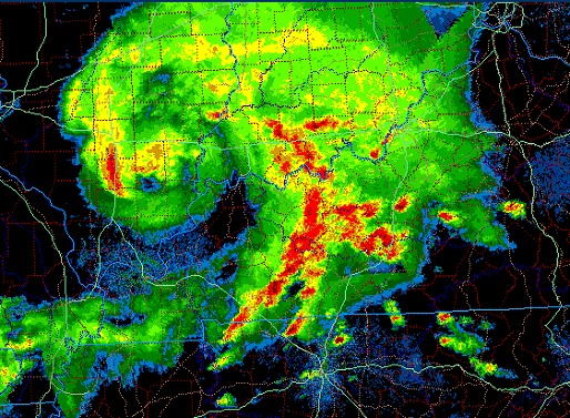
Regional radar image at 3:04PM EDT showing well-developed MCV
|


