|
Home | Blog Index | Blog Archives | Christianity & Faith Essays | Storm Chasing Essays
2018 storm season blog kickoff
 It's that time of year again! We've made it through a very cold and long meteorological winter, and it's time to welcome the increasingly warm air, green foliage, open roads and of course the world-famous severe weather season in the Midwest and Great Plains. It's that time of year again! We've made it through a very cold and long meteorological winter, and it's time to welcome the increasingly warm air, green foliage, open roads and of course the world-famous severe weather season in the Midwest and Great Plains.
The plan this year is the typical one - ongoing coverage of Midwest severe weather (roughly within 3 hours of St. Louis) as well as one to three Great Plains storm chase expeditions in April, May and/or June when the conditions for tornadoes materialize there. As with previous seasons, the probabilities of Plains trips in March are low - but not out of the question if a good enough setup presents itself.
Vehicle setup-wise, I'm considering some modifications to the hail shields. Most notably:
- Removal of the front windshield guard: While it has protected the windshield multiple times, it gets in the way of photography, video and more importantly, the front dash camera. The front windshield is still vulnerable to hail damage when driving above 30 to 40mph, as golf-ball sized stones can come in at an angle and strike the very bottom of the glass. This happened last year, resulting in a crack that will warrant the replacement of the windshield. The front guard has saved the windshield from total destruction, so I am not 100% on getting rid of it yet.
- Fully stowable single-panel side guards, as opposed to the current larger two-panel design (one panel permanent, the other stowable). This will result in a lighter overall weight for the entire rig.
- Powered guard deployment: I'm considering a design that will allow for deployment of the side (and possibly front) guards from inside of the vehicle using 12-volt linear actuators. This aspect of the plan is rather ambitious, and will depend highly on the cost of the necessary components.
On to the weather! Let's take a look at what models are showing for the first week or two of meteorological spring. Right out of the gate, we have a system to watch in the Plains for this Sunday. A nice "negatively tilted" shortwave trough (meaning a smaller trough embedded in the broader upper larger pattern) is moving out over the Plains as the first hints of a spring dryline begin in Kansas and Oklahoma. "Negative tilt" means that an imaginary line drawn to bisect the trough would be tilting backwards:
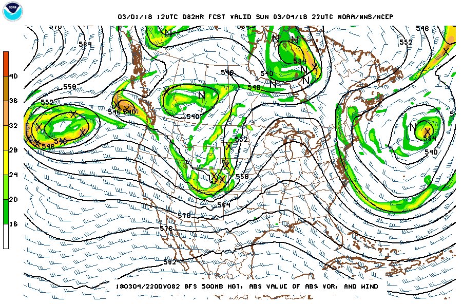
500mb pattern for March 4
The upper pattern is as good as anything we'd like to see in the Plains in the spring, but the setup is lacking in the other big necessary ingredient for severe storms: moisture. As is common with setups this early in the season, the low-level moisture transport from the Gulf of Mexico has not yet become well-established. As a result, the available instability on the dryline for this setup will be very meager. Models show a strong cap that will need to be overcome before storms can develop, and currently it does not appear that this will happen before sunset. A couple of after-dark supercells appear likely between Wichita and Oklahoma City, which could put on a nice lightning/storm structure show. A tornado or two is not out of the question, but the storms will have to overcome the deficient moisture to produce - and right now it looks like any chance for this will be well after dark. It's not looking like a chase worthy of the drive from St. Louis, but certainly could be a nice evening for storm chasers who live close by to dust off their equipment for the first outing of the season.
Beyond that, the pattern looks typical for March: lots of upper-level energy passing through with some attempts at low-level moisture to make its way north here and there. As far as we can realistically hazard a guess (10 days or so) there aren't any huge outbreak setups evident. However, it's that time of year where storm chasers need to keep an eye on the forecast, as the medium-range outlook can change in the course of a few days.
The following table charts the probabilities for a Plains storm chase expedition taking place for the date ranges shown:
| 2018 Plains Storm Expeditions - Probabilities as of March 1 |
| March 4 | 5% | |
| March 5-15 | 2% | |
|
GO: Home | Storm Chase Logs | Photography | Extreme Weather Library | Stock Footage | Blog
Featured Weather Library Article:
|


