|
Home | Blog Index | Blog Archives | Christianity & Faith Essays | Storm Chasing Essays
April 2021 storm chasing roundup
April 2021 was a pretty slow month for storms in the Midwest. Mostly since I am focusing more on high speed lightning video these days, I opted not to chase the past few supercell/tornado events down in Texas and southern Oklahoma. I'm waiting for the more lightning-potent setups of May and June for Plains chases.
Moving on, here's the rundown of storms chased during this April.
 April 7: Thunderstorms along I-70 in Missouri April 7: Thunderstorms along I-70 in Missouri
I drove west to Kingdom City with the intention to follow the developing storms along I-70 back east into St. Louis. The storms evolved as expected, but the lightning was uncooperative for my camera.
 April 9: Freeburg, IL lightning April 9: Freeburg, IL lightning
Another day with better storms mostly south of St. Louis. I decided to wait for storms models showed firing just south of the STL metro toward late evening. I captured a few high speed lightning shots from these near Freeburg, IL, which can be seen in this compilation of high-speed shots from 2021:
 April 20: St. Louis snow April 20: St. Louis snow
A *very* late-in-year snow event impacted St. Louis on Tuesday the 20th. I was out in the metro area monitoring for road impacts, but did not encounter any thanks to the above-freezing temperatures. I stopped at the Arch to shoot a short cell phone slow-motion clip:
 April 26: Check-swing Kansas non-trip April 26: Check-swing Kansas non-trip
I had been wavering on whether to make a trip to northwestern Kansas/eastern Colorado for the season's first Plains chase. Models had been showing potential for photogenic supercells with possibly good lightning in this area. But as the event drew closer, models continually trended downward with instabilty in that area, while showing storms possible close to St. Louis for the next two days. I was still undecided at my go/no-go decision time of midnight, so I had to begin the drive west and make the final decision at some point on the road. At my first data check stop at Warrenton, this downward trend continued, so I made the call to abort the trip and head back home.
I call these situations "check swing" trips. It's like a batter who is undecided on a coming pitch who has to begin the motion of a swing. With all of my weather trips, there is always uncertainty on whether a long drive will be worth it. Ideally, models will be consistent and in agreement on a weather event, meaning the decision to go can be made a day or two in advance of my actual departure. If models are having trouble with a system or it otherwise remains unclear how an event will evolve, I'll have to delay making the decision to go. The problem is there comes a critical point where I have to leave, or else I will not make it to the target event in time. If I am still undecided at that critical point, I have no choice but to begin the drive as if I am going. To not leave at that point would be effectively a no-go decision, as to leave any later would mean missing the target event anyway.
On a check-swing trip, I'll stop to check data every so often to see if the forecast is becoming more clear. When it does, I will either continue on to the target (executing the swing), or I'll turn around and go back home (a check swing).  April 27: New Madrid, MO severe storm April 27: New Madrid, MO severe storm
This was another situation where I had to choose between storms in Oklahoma/Texas or storms a couple of hours south of home. I awoke at 10pm on the 26th to prepare for a potential all-night drive to southwestern Oklahoma/north Texas, but I was not liking the data I was seeing at all. Instability was looking more meager along the Red River/north Texas regions thanks to persistent ongoing convection, and the viable supercell environments were much farther south - that is, along and south of I-20 into the Texas hill country. My go/no-go decision time for the Red River/North Texas target area was 4AM, and by then I had long since decided that I would rather play the close-to-home option in the Missouri bootheel (I usually will choose a local supercell/tornado environment (if one exists) over driving to a Plains environment). The 2.5 hour drive certainly was a more appealing prospect than a 14 hour one for what appeared to be equal chances for photogenic lightning. After a short nap in the morning, I headed south on I-55.
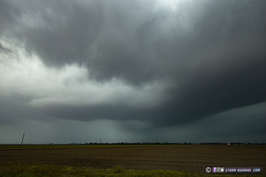
Models had insisted on storms in northwestern Arkansas and southwestern Missouri intensifying around 5PM as they approached the Mississippi River around Sikeston. This seemed reasonable, given convection-free northeastern Arkansas and even some filtered sunlight making it through the cirrus deck. As a backup plan, I hedged halfway between there and Cape Girardeau for an upward lightning option north of the city should it become viable. Eventually the target storms seemed to be developing as they were forecast, so I dropped down to intercept the tail end cell at New Madrid.
When I arrived, I was surprised to see a nice RFD clear slot cutting into a small base, with midlevel inflow banding streaming into everything above.
This feature quickly vanished in the rain, however, and the precip quickly engulfed I-55. I had the option to cross the river at Cairo and re-intercept the storm in Kentucky, but decided it wasn't going to be worth it. I arrived back home by 7:30PM.
That covers the month of April. Models are hinting that May could be an active month, so stay tuned!
GO: Home | Storm Chase Logs | Photography | Extreme Weather Library | Stock Footage | Blog
Featured Weather Library Article:
|


