Atmospheric moisture content as a potential factor in fast vs slow states of positive lightning leaders
The purpose of this study is to investigate the hypothesis that atmospheric moisture content (represented by dewpoint temperature) plays a role in whether positive lightning leaders are slow (highly branched) versus fast (branchless) below cloud base. This page is a work-in-progress and will be updated as more data is collected.
Background information
High-speed video of lightning reveals that positive lightning leaders have two distinct states of propagation: fast and slow [ 1]. A fast positive leader propagates at greater speeds and rarely branches, while a slow positive leader branches extensively. Positive lightning leaders have also been observed transitioning in state from slow to fast or from fast to slow. Many of the branches of slow positive leaders are weakly luminous and have a tendency to produce recoil leaders that re-illuminate the branch. Occasionally, these recoil leaders will result in the initiation of a dart leader that travels from the branch either partway or all the way down the parent channel. In the case of a cloud-to-ground or ground-to-cloud lightning flash with the negative end connected to the ground, a dart leader that propagates all the way to the ground will result in a subsequent return stroke.
With their numerous recoil leaders, multiple return strokes and large areas of sky covered, lightning flashes consisting of slow positive leaders below cloud base are typically the most visually spectacular - both to the in-person observer and when captured on still photographs or video.
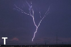
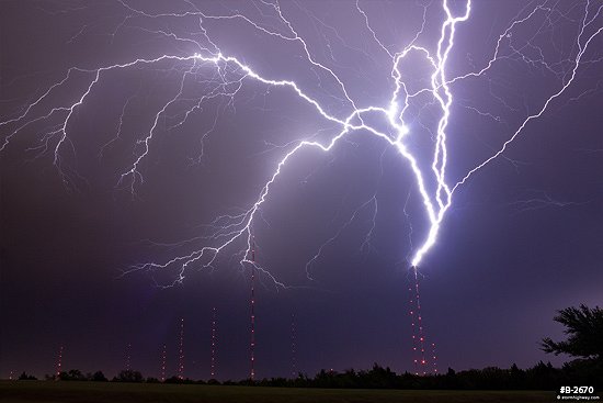 Upward lightning flash showing the highly-branched nature of slow positive leaders. Upward lightning flash showing the highly-branched nature of slow positive leaders.
It is currently not known what conditions determine whether a positive lightning leader will be fast or slow. Hypothesis
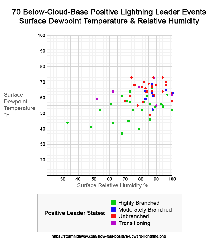
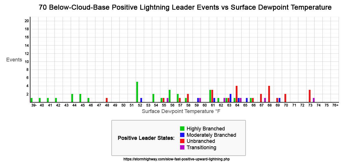
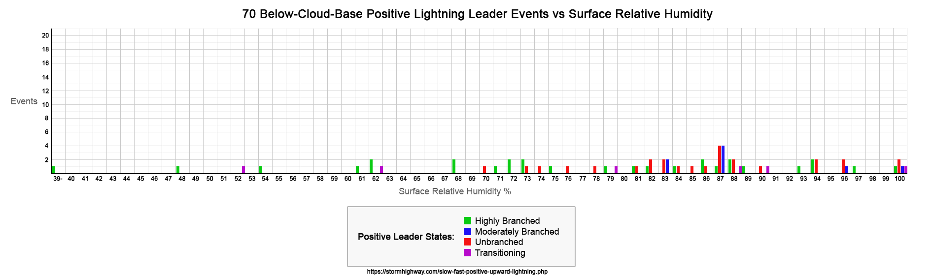
Photographic and video evidence suggests that positive leaders that propagate through air with lower moisture content (surface dewpoints at or below 60°F) are more likely to be of the "slow" variety (slower propagation and highly-branched). The converse of this hypothesis is that positive leaders propagating through air with higher moisture content (dewpoints higher than 60°F) are more likely to be of the "fast" variety and therefore unbranched.
The hypothesis suggests that slow positive leaders below cloud base are more likely to occur with events:
- During the cool season (late fall through early spring)
- At higher altitudes
- In more arid locations (desert, high plains, US west coast)
The hypothesis suggests that fast positive leaders below cloud base are more likely to occur with events:
- During the warm season (late spring through early fall)
- At lower altitudes
- In more humid locations (US Midwest, Gulf Coast, Florida)
Methodology
The primary methodology for this study involves:
- Collecting photographic and video examples of lightning flashes where positive leaders propagate below cloud base and where the approximate date, time and location of the event can be determined.
- Retrieving surface temperature, surface dewpoint temperature and atmospheric skew-t profile records from the nearest ASOS, AWOS, upper air sounding and/or model-derived data source at (or as close as possible to) the time of the event.
Most observed upward lightning occurs with man-made structures that are taller than 200m. As such, a vertical temperature/dewpoint profile of at least the lowest 2km of atmosphere will be necessary to represent the conditions in the volume of air the leaders are propagating through. The surface dewpoint temperature value, while not necessarily representative of the conditions at leader altitude, can serve as a proxy where sounding data is not available. During most warm-season thunderstorm environments, the surface dewpoint temperature is at its maximum at the surface, meaning the leader-altitude dewpoint temperature will usually be lower.
The goal of this study is to investigate if a correlation exists between fast vs slow leader state and dewpoint temperature, and if such a correlation exists, determine the threshold dewpoint temperature where fast vs slow transition occurs.
This page will serve as an ongoing repository for the collection of observed upward lightning flash events and the corresponding meterological data. Flash type definitions
This study will focus primarily on upward positive leaders, but other flashes with below-cloud-base positive leaders will also be analyzed.
- Upward (U): Upward positive leader from tall objects or terrain.
- Downward (D): Downward positive leader during a ground flash.
- Cloud (C): Cloud flash leader.
- Low-altitude cloud (L): A cloud flash where a leader propagates more than halfway to the ground from cloud base, but does not contact the ground.
Leader type definitions
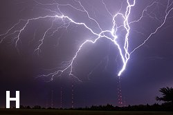
- Highly branched leader (H): Exhibits at least 3 branching points in the lower third of the visible flash below cloud base.
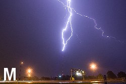
- Moderately branched leader (M): Exhibits only one or two branching points in the lower third of the visible channel below cloud base.
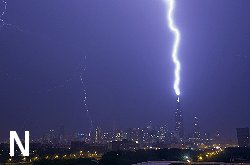
- Unbranched leader (N): Exhibits no branching below cloud base.
- Transitioning leader (T): Exhibits a transition from unbranched to highly branched (or vice versa) at a point less than two-thirds below cloud base.
Examples:
Charts of 70 collected events to date
|
Highly-Branched Positive Leader Event List
| Date & Link |
Location |
Approx.
Time |
SFC
TMP °F |
SFC
DP °F |
SFC
RH % |
Flash
Type |
Notes |
| 7/4/03 |
Sioux City, IA |
12:00AM |
73 |
64 |
73 |
U |
|
| 4/3/07 |
St. Albans, WV |
11:51PM |
58 |
56 |
93 |
U |
|
| 1/7/08 |
Chicago, IL |
8:19PM |
55 |
54 |
94 |
U |
|
| 4/10/09 |
St. Albans, WV |
6:53PM |
55 |
52 |
88 |
U |
|
| 4/26/09 |
Oklahoma City, OK |
11:21PM |
63 |
57 |
82 |
U |
(3) |
| 8/20/11 |
St. Louis, MO |
5:51AM |
76 |
66 |
87 |
U |
|
| 5/23/14 |
New York, NY |
8:51PM |
60 |
52 |
75 |
U |
|
| 11/11/15 |
Chicago, IL |
7:53PM |
61 |
41 |
48 |
U |
|
| 3/15/16 |
Chicago, IL |
10:53PM |
50 |
46 |
86 |
U |
|
| 4/27/16 |
Bruceville-Eddy, TX |
12:48AM |
64 |
61 |
88 |
U |
|
| 5/17/16 |
Clinton, OK |
2:18AM |
57 |
55 |
94 |
U |
|
| 4/29/17 |
Barry County, MI |
11:40PM |
47 |
37 |
68 |
U |
|
| 5/18/17 |
Oklahoma City, OK |
8:52PM |
70 |
56 |
61 |
U |
|
| 6/3/17 |
Kansas City, MO |
9:21PM |
54 |
45 |
72 |
U |
|
| 3/22/19 |
Amarillo, TX |
8:53PM |
46 |
40 |
79 |
U |
|
| 1/10/20 |
Coweta, OK |
5:42PM |
52 |
52 |
100 |
U |
|
| 5/30/20 |
Castle Valley, UT |
10:53PM |
69 |
52 |
54 |
U |
(2) |
| 6/17/20 |
Lubbock, TX |
7:53PM |
72 |
61 |
68 |
U |
|
| 7/12/20 |
Oklahoma City, OK |
12:52AM |
77 |
63 |
62 |
U |
|
| 5/17/21 |
Abilene, TX |
10:52PM |
70 |
58 |
71 |
D |
|
| 5/19/21 |
San Antonio, TX |
8:04AM? |
66 |
62 |
97 |
U |
|
| 10/4/21 |
Hollywood, CA |
5:53PM |
75 |
44 |
33 |
U |
(1) |
| 3/29/22 |
Wichita, KS |
9:53PM |
58 |
52 |
81 |
U |
|
| 4/29/22 |
Kansas City, MO |
11:54PM |
57 |
54 |
89 |
U |
|
| 10/2/22 |
Moab, UT |
6:55PM |
53 |
|
|
U |
(2)(4) |
| 4/1/23 |
New York, NY |
7:51PM |
57 |
44 |
62 |
U |
|
| 4/15/23 |
St. Louis, MO |
8:03PM |
60 |
56 |
86 |
U |
(3) |
| 4/18/23 |
Houston, TX |
|
|
|
|
U |
|
| 4/19/23 |
Chicago, IL |
6:53PM |
54 |
45 |
72 |
U |
|
| 5/7/23 |
Oglesby, IL |
9:21PM |
66 |
61 |
84 |
U |
|
| 5/29/23 |
Sierra Buttes, CA |
3:56PM |
|
|
|
U |
(1)(2) |
| 6/7/23 |
Lubbock, TX |
11:53PM |
66 |
57 |
73 |
U |
|
|
Moderately-Branched Positive Leader Event List
| Date & Link |
Location |
Approx.
Time |
SFC
TMP °F |
SFC
DP °F |
SFC
RH % |
Flash
Type |
Notes |
| 5/30/01 |
Oklahoma City, OK |
2:05AM |
63 |
63 |
100 |
U |
|
| 5/7/07 |
Oklahoma City, OK |
2:59AM |
64 |
59 |
83 |
U |
|
| 6/3/08 |
St. Albans, WV |
5:51PM |
73 |
69 |
87 |
U |
|
| 6/19/11 |
St. Louis, MO |
3:00AM |
70 |
64 |
83 |
U |
(3) |
| 4/3/18 |
Pittsburgh, PA |
11:00PM |
56 |
52 |
87 |
U |
|
| 8/25/19 |
Wichita, KS |
4:53AM |
65 |
61 |
87 |
U |
|
| 9/8/19 |
St. Louis, MO |
6:51AM |
67 |
63 |
87 |
U |
(3) |
| 6/6/22 |
Tulsa, OK |
5:00AM |
66 |
65 |
96 |
U |
|
|
Unbranched Positive Leader Event List
| Date & Link |
Location |
Approx.
Time |
SFC
TMP °F |
SFC
DP °F |
SFC
RH % |
Flash
Type |
Notes |
| 5/30/01 |
Oklahoma City, OK |
2:05AM |
63 |
63 |
100 |
U |
|
| 4/10/04 |
Raleigh, NC |
5:51PM |
88 |
58 |
70 |
U |
|
| 2/6/08 |
Lexington, KY |
2:28AM |
63 |
57 |
82 |
U |
|
| 7/20/06 |
Chicago, IL |
6:11AM |
72 |
66 |
83 |
U |
|
| 6/19/09 |
Chicago, IL |
6:32AM |
66 |
64 |
94 |
U |
|
| 6/19/11 |
St. Louis, MO |
3:00AM |
70 |
64 |
83 |
U |
(3) |
| 6/30/14 |
Chicago, IL |
8:02PM |
71 |
68 |
90 |
U |
|
| 6/30/14 |
Chicago, IL |
11:04PM |
69 |
68 |
96 |
U |
|
| 3/14/16 |
Pittsburgh, PA |
9:51PM |
53 |
49 |
86 |
U |
|
| 7/21/17 |
Chicago, IL |
9:53PM |
75 |
73 |
94 |
U |
|
| 6/2/18 |
Eagle, NE |
2:51AM |
64 |
61 |
88 |
U |
|
| 6/30/19 |
Chicago, IL |
2:53PM |
74 |
69 |
85 |
U |
|
| 8/25/19 |
Wichita, KS |
4:53AM |
65 |
61 |
87 |
U |
|
| 8/29/19 |
Kansas City, MO |
10:54PM |
69 |
64 |
84 |
U |
|
| 9/15/19 |
Chicago, IL |
1:20AM |
70 |
61 |
73 |
U |
|
| 8/10/20 |
Chicago, IL |
4:53PM |
71 |
67 |
87 |
U |
|
| 7/9/21 |
St. Louis, MO |
9:00PM |
77 |
73 |
88 |
U |
|
| 8/10/21 |
New York, NY |
8:08PM |
76 |
70 |
82 |
U |
|
| 10/11/21 |
Chicago, IL |
4:35PM |
68 |
64 |
87 |
U |
|
| 5/17/22 |
Wichita, KS |
3:53AM |
62 |
55 |
78 |
U |
|
| 4/30/23 |
New York, NY |
5:51PM |
58 |
58 |
100 |
U |
|
| 7/12/23 |
St. Louis, MO |
9:00PM |
82 |
73 |
74 |
U |
|
| 7/29/23 |
Chicago, IL |
12:53AM |
73 |
67 |
81 |
U |
|
| 8/2/23 |
St. Louis, MO |
6:51AM |
72 |
68 |
87 |
U |
|
| 8/9/23 |
Huntsville, AL |
4:57PM |
71 |
70 |
96 |
U |
|
| 8/12/23 |
St. Louis, MO |
5:51AM |
74 |
68 |
76 |
U |
|
|
Transitioning Positive Leader Event List
| Date & Link |
Location |
Approx.
Time |
SFC
TMP °F |
SFC
DP °F |
SFC
RH % |
Flash
Type |
Notes |
| 3/29/17 |
Austin, TX |
3:53AM |
62 |
62 |
100 |
U |
|
| 5/27/17 |
St. Louis, MO |
5:04PM |
74 |
67 |
79 |
U |
|
| 7/9/21 |
St. Louis, MO |
9:00PM |
77 |
73 |
88 |
U |
|
| 9/13/21 |
New York, NY |
9:51PM |
78 |
59 |
52 |
U |
|
| 5/21/22 |
St. Louis, MO |
6:00AM |
58 |
55 |
90 |
U |
|
| 4/4/23 |
Industry, IL |
5:54PM |
78 |
64 |
62 |
D |
|
|
Notes key
- Occurred at a high elevation or mountain peak at a significantly higher altitude than the nearest surface observation
- No official surface observations available within a 50 mile radius. Observation is at the closest ASOS/AWOS station available.
- The storm produced both branched and unbranched positive leader flashes before and/or after the recorded event.
- Some ASOS/AWOS data was faulty or missing for this event.
References
- Positive and negative lightning leaders by Tom Warner
GO: Home | Storm Chase Logs | Photography | Extreme Weather Library | Stock Footage | Blog
Featured Weather Library Article:
|
|


