11 years on the web
Storm Highway celebrated 10 years of growth and success on the web last October. As we approach our 11th anniversary, we've compiled a short history of the site, including a few glimpses from the past.
Read more
 NEW: Storm Highway Photo CD NEW: Storm Highway Photo CD
750 Royalty-Free* Storm and Weather Photos
Just released! Our new Storm Highway Photo CD is a two-disc CDROM set contaning 750 photos of lightning, tornadoes, clouds, auroras, floods, storm damage, rainbows and more! Perfect for applications such as desktop publishing, advertising, web, onscreen video graphics, and more.
More information
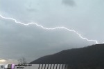
Pittsburgh Lightning Show
 Storm Highway video and photography from Pittsburgh in June: Storm Highway video and photography from Pittsburgh in June:
VIDEO CLIPS (Available from Storm Highway and in HD from Storm Highway HD):
CLIP 1: HD Pittsburgh lightning show at night
CLIP 2: HD Lightning in Pittsburgh at dusk
CLIP 3: HD Lightning over Pittsburgh skyscrapers
CLIP 4: Lightning over Pittsburgh skyline
CLIP 5: Afternoon Pittsburgh lightning
CLIP 6: Lightning over Pittsburgh skyscrapers
DIGITAL STILLS:
Spectacular lightning over Pittsburgh from June's storms are available in high-resolution from Matt Robinson at pittsburghskyline.com.
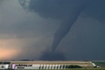
2006 Event Trip - Our 6th annual storm chase expedition to the Great Plains has come to a close. This year's trip was less than optimal, with marginal storms and major vehicular problems. However, we were still able to come home with spectacular photos and video. Check out our storm season blog for more details!
[ 2006 storm storm chase expedition blog ]
April 17: Storms keep lighting up WV
ST. ALBANS, WV - The active weather pattern continued throught the weekend with storms affecting the state again early Monday morning. The WVAH television tower in St. Albans, as is common during thunderstorms, was struck several times before sunrise. Left: Close-up shot of a lightning strike to a TV tower in St. Albans.
[ Full story and more photos ]
GALLERY: Lightning in Clarksburg and Parkersburg on Friday
GALLERY: Gallatin & Goodlettsville, Tennessee tornado aftermath
CHASE LOG WITH PHOTOS: April 7 chase to Tennessee and Alabama
April 1: April arrives with a show
CHARLESTON, WV - Thunderstorms heralded the arrival of April in West Virginia early Saturday morning. Left: Lightning over the State Capitol on Saturday.
[ Full story and more photos ]
March 21: Icy roads return for spring
CHARLESTON, WV - Even though the calendar says it's spring, drivers still shouldn't let down their guard against the weather. Snow, sleet and freezing temperatures made bridges and overpasses slick in West Virginia on Tuesday night, causing numerous accidents on state highways. Left: A car spins out on the icy I-64 Oakwood bridge in Charleston on Tuesday night.
[ Full story and more photos ]
VIDEO: Accidents caught on camera on Tuesday : Windows Media, 2.0MB
February 12: Snowstorm affects Mountain State
FAYETTEVILLE, WV - A Nor'easter storm affected West Virginia with the highest storm total accumulations so far this season for many parts of the state. The Charleston area saw 3 to 5 inches of snow, while some of the mountain regions saw 7 inches or more.
[ Full story and more photos ]
January 18: Slippery roads strike again
CHARLESTON, WV - Wet roads and high speed contributed to a single-vechicle accident at I-64's notorious Oakwood bridge curve early on Wednesday morning. The accident was caught on tape by a Storm Highway cameraman who happened to be at that location shooting overnight weather video. The car entered the sharp curve at a high rate of speed, lost control, hit the left barrier, spun around, struck the right barrier, and finally rolled over onto its roof.
[ Full story and more photos ]
VIDEO: Rollover accident caught on camera : Windows Media, 1.9MB
January 2: Lightning suspected in mine tragedy
TALLMANSVILLE, WV - Lightning from a round of unusual wintertime thunderstorms on Monday morning may be to blame for an explosion at the Sago underground coal mine in Upshur County. 12 miners were killed in the disaster. LEFT: In this video image, the thunderstorm suspected of causing the Upshur County mine explosion lights up the sky in Charleston about an hour before the accident.
[ Full story and more photos ]
MEDIA NOTICE: Video from the lightning storm that may have caused the Tallmansville mine explosion is available from Appalachian Skies. Please visit our Breaking News Page for more information.
November 8: Intense storms blast state
CHARLESTON, WV - Summer-like thunderstorms, well out of season for November, crashed through West Virginia on Tuesday and Tuesday night. In Charleston, a staggering barrage of vivid lightning after dark ravaged the downtown area, causing power outages and giving a startling display of nature's power.
[ Full story and more photos ]
EXPEDITION VIDEO: Charleston under attack from lightning barrage : Windows Media, 6.8MB
October 25: 2nd day of snowfall coats roads
SHADY SPRING, WV - Snow began falling in earnest late Tuesday afternoon in the mountains of West Virginia. Beckley remained snow-free initially, but just to the east in Shady Spring, the snow came in heavy and fast. Roads remained clear, but bridges and overpasses quickly became covered with a slick coating of snow and ice. Many motorists were taken by surprise when they encountered the slick bridges.
[ Full story and more photos ]
VIDEO: Pickup truck accident caught on video, WMV 3.7MB
On-Location Hurricane Rita Photo Gallery and Video
 
Storm Highway ON-LOCATION VIDEO: Hurricane Rita slams the Texas coast: In Port Arthur, a Dairy Queen falls apart and a Wendy's sign blows out. In Beaumont, power lines spark, winds blast through downtown and at a hospital. WMV, 15MB
[ Full story and more photos ]
 New Feature Article New Feature Article
"Lightning discharges to TV towers, antennas and other tall structures" is our newest online article that takes an in-depth look at the unique 'ground-to-cloud' type of lightning, with animations, illustrations, photos and video.
[ Full article ]
May 7: Hebrews 10:23 - Take a look at another story of God showing up in the life of an ordinary person.
August 29: Flooding hits Kanawha County
ELKVIEW, WV - Slow-moving thunderstorms dumped heavy rain across the state on August 29, creating moderate flooding problems across the region.
[ Full story and more photos ]
EXPEDITION VIDEO: Floodwaters rush over a low water bridge on Little Sandy Creek: Windows Media, 6.8MB
SPECIAL SECTION: HURRICANE KATRINA:
Archived information and links on the Hurricane Katrina disaster, including links to observer photos and video, satellite imagery and relief information. [ Hurricane Katrina Page ]
August 20: Bolts from the blue
CLENDENIN, WV - Storms with frequent lightning affected most of the state through Saturday night. Severe weather was commonplace in the Pittsburgh area, but most of West Virginia was spared from any significant damaging storms.
[ Full story and more photos ]
EXPEDITION VIDEO: 'Bolts from the blue' from growing cumulonimbus cloud: Windows Media, 4.7MB
August 6: Creeks rise fast in WV
GREEN SULPHUR SPRINGS, WV - A stalled frontal boundary was the focus for thunderstorms again in southern West Virginia on Saturday afternoon. The storms moved very little or not at all, producing heavy rainfall and minor flooding incidents.
[ Full story and more photos ]
EXPEDITION VIDEO: How fast can a flash flood happen? Watch: Windows Media, 7.4MB
August 5: Severe storms hit Appalachians
GLENWOOD, WV - A slow-moving frontal boundary helped fire thunderstorms mainly in the tri-state region near Huntington and into southeast Ohio. Severe weather was reported in some areas in the form of hail and damage from strong winds. Minor flooding was experienced under the slower-moving storms. A second area of severe storms developed along the high terrain near Lewisburg and White Sulpher Springs and into western Virginia.
[ Full story and more photos ]
July 31: Storms create highway dangers
BECKLEY, WV - Thunderstorms developed on Sunday afternoon near Webster Springs and traveled southwest along the eastern mountains of West Virginia, producing hail, lightning and heavy rain which caused hazardous conditions on area roads. Locations affected included Summersville, Fayetteville, Oak Hill, Beckley and Bluefield.
[ Full story and more photos ]
EXPEDITION VIDEO: Tractor-trailer wreck caught on camera, RealVideo, 2.2MB, full-screen video
July 27: Lightning kills man in St. Albans
CHARLESTON, WV - Numerous thunderstorms developed across the state of West Virginia on Wednesday, bringing a barrage of lightning and heavy rain to most areas. Some locations saw as many as a half dozen individual thunderstorms throughout the afternoon.
[ Full story and more photos ]
 Back from the Plains Back from the Plains
CHARLESTON, WV - The 2005 storm chase expedition has finally come to a close, a trip during a memorable season that started slow and ended with a bang. Our tornado intercept tally for the season is 14. We'll be posting more photos and video in the coming days. In the meantime, you can catch a glimpse of a few photos and video clips on our storm chase expedition blog.
[ 2005 Storm Chasing Expedition Blog ]

Amazing tower lightning! June 14, 2005 - Watch lightning repeatedly strike a TV tower near St. Albans, WV, "up close and personal" with cameras set up a few hundred yards away.
[ Full story and more photos ]
July 25: Storms kill 2, cause damage across WV
CHARLESTON, WV - A widespread severe weather event occured across the Mountain State on Monday afternoon when a large convective complex raced southeast from Ohio and into West Virginia. The bow-echo line of storms produced damaging winds along virtually all of its length as it plowed through.
[ Full story and more photos ]
July 19: Flooding hits Kanawha County
CHARLESTON, WV - Strong thunderstorms slowly moved over the Charleston area on Tuesday, triggering flash flooding across portions of the county.
[ Full story and more photos ]
June 29: Daily, nightly storms
HUNTINGTON, WV - Storms popped up in abundance around the state on Thursday, with the strongest storms affecting the western half of the region. The Huntington area saw a bout of heavy rain that overwhelmed storm drains on I-64 westbound, flooding the highway and bringing traffic to a crawl.
[ Full story, video and more photos ]
EXPEDITION VIDEO: Lightning south of Charleston on Wednesday night: WMV Clip, 1.8MB
June 27: Storms rock Mercer County
ATHENS, WV - Slow-moving storms brought an end to the oppressive heat in southern West Virginia, but the relief came at a cost to some areas. The Athens area saw strong storms which caused wind damage, flash flooding and power outages.
[ Full story and more photos ]
Back from the Plains
CHARLESTON, WV - The 2005 storm chase expedition has finally come to a close, a trip during a memorable season that started slow and ended with a bang. Our tornado intercept tally for the season is 14. We'll be posting more photos and video in the coming days. In the meantime, you can catch a glimpse of a few photos and video clips on our storm chase expedition blog.
[ 2005 Storm Chasing Expedition Blog ]
Amazing tower lightning! June 14, 2005 - Watch lightning repeatedly strike a TV tower near St. Albans, WV, "up close and personal" with cameras set up a few hundred yards away.
[ Full story and more photos ]
May 23: Monday evening storms
CHARLESTON, WV - An area of weak thunderstorms moved across the Charleston metro on Monday afternoon. Rainbows and lightning were common sights for evening motorists.
[ Full story and more photos ]
EXPEDITION VIDEO: Lightning in Charleston on Monday, RealVideo, 1.2MB
May 19: Storms last into the night
HUNTINGTON, WV - Several strong thunderstorm cells moved across the Huntington and Charleston metro areas on Thursday afternoon and later into the evening. Heavy rain and frequent lightning were the primary threats, though hail and damaging winds have been reported across the region.
[ Full story and more photos ]
EXPEDITION VIDEO: Lightning in Charleston and Huntington, Windows Media, 4MB
 May 15: Mid-May Aurora Borealis show May 15: Mid-May Aurora Borealis show
CHICAGO, IL - A strong solar flare triggered an extremely bright display of the Northern Lights on Saturday night, and from our vantage point just south of Chicago, the show was spectacular - filling nearly the entire sky, from horizon to horizon and straight above. RIGHT: Intense Aurora Borealis in Illinois on Saturday night (photo by Matt Robinson of raleighskyline.com).
[ Full story and more photos ]
VIDEO CLIP: Aurora Borealis display in northern Illinois, Windows Media, 3MB
 April 30: Rains bring flooding to KY, WV April 30: Rains bring flooding to KY, WV
LOGAN, WV - Persistent heavy rains lasting all night on Friday caused many creeks and streams to overflow their banks in southern West Virginia and eastern Kentucky. While the flooding was not severe, typical problems were common such as blocked roads and waterlogged yards. RIGHT: Floodwaters cover a road in Logan on Saturday morning, from Storm Highway video on The Weather Channel on April 30.
[ Full story and more photos ]
 April 25: Winter springs back April 25: Winter springs back
BECKLEY, WV - Winter made a brief comeback over the weekend as a strong cold front swept through the area, changing the rain to snow across the entire state. Most areas saw a dusting, with the mountain counties seeing several inches of springtime snow. The wet and snowy roads contributed to several serious accidents on state highways, the most dramatic of which occured at Cabin Creek on the West Virginia Turnpike. RIGHT: Snow covers blooming flowers in Beckley, from Storm Highway video on The Weather Channel on April 25.
[ Full story and more photos ]
 VIDEO: Fire and small explosions engulf a wrecked car on I-77 at Cabin Creek after an accident on a rain-slickened curve: Windows Media, 6MB VIDEO: Fire and small explosions engulf a wrecked car on I-77 at Cabin Creek after an accident on a rain-slickened curve: Windows Media, 6MB
 In the News: In the News:
Special thanks to WOWK-TV Channel 13 for running the following story on their April 22 11PM newscast!
VIDEO: News story on April 22 (Courtesy WOWK-TV): Windows Media, 6MB
 On TV Worldwide - Storm Highway video footage of flooding is currently appearing in a National Geographic production titled "Surviving Hurricane Floyd". Surviving Hurricane Floyd premieres Tuesday, March 8 at 9PM Eastern on the National Geographic Channel. On TV Worldwide - Storm Highway video footage of flooding is currently appearing in a National Geographic production titled "Surviving Hurricane Floyd". Surviving Hurricane Floyd premieres Tuesday, March 8 at 9PM Eastern on the National Geographic Channel.
LINK: National Geographic Channel
 April 22: Storms plow through April 22: Storms plow through
POINT PLEASANT, WV - Storms fired across West Virginia during the day on Friday, bringing heavy rain, strong winds and a show of lightning to the state. The severe weather expected to occur turned out to be minimal, though the skies were alive with 'natural fireworks' into the night. RIGHT: Close-up view of lightning striking the WVAH-TV tower in Putnam County on Friday night.
[ Full story and more photos ]
VIDEO: Lightning strikes the WVAH tower on Friday: RealVideo, 1.9MB
 April 3: Springtime 'Snow Tornadoes' April 3: Springtime 'Snow Tornadoes'
CASS, WV - A strong springtime cold front brought what could be the region's last snowfall of the season on April 3. The potent front carried with it strong winds that produced minor damage and power outages across the state, as well as a dramatic display of blowing snow and 'snow devils' across the mountainous counties. 'Snow devils', rotating tornado-like columns of air that picked up snow in their vorticies, are similar to their warm-air counterpart, the 'dust devil'. These rare 'snow tornadoes' were visible across the mountains of West Virginia on April 3 as the winds lifted the freshly fallen snow.
[ Full story and more photos ]
VIDEO: 'Snow tornadoes' in Cass: RealVideo, 2.5MB
April 30: Rains bring flooding to KY, WV
LOGAN, WV - Persistent heavy rains lasting all night on Friday caused many creeks and streams to overflow their banks in southern West Virginia and eastern Kentucky. While the flooding was not severe, typical problems were common such as blocked roads and waterlogged yards. RIGHT: Floodwaters cover a road in Logan on Saturday morning, from Storm Highway video on The Weather Channel on April 30.
[ Full story and more photos ]
April 25: Winter springs back
BECKLEY, WV - Winter made a brief comeback over the weekend as a strong cold front swept through the area, changing the rain to snow across the entire state. Most areas saw a dusting, with the mountain counties seeing several inches of springtime snow. The wet and snowy roads contributed to several serious accidents on state highways, the most dramatic of which occured at Cabin Creek on the West Virginia Turnpike. RIGHT: Snow covers blooming flowers in Beckley, from Storm Highway video on The Weather Channel on April 25.
[ Full story and more photos ]
VIDEO: Fire and small explosions engulf a wrecked car on I-77 at Cabin Creek after an accident on a rain-slickened curve: Windows Media, 6MB
April 22: Storms plow through
POINT PLEASANT, WV - Storms fired across West Virginia during the day on Friday, bringing heavy rain, strong winds and a show of lightning to the state. The severe weather expected to occur turned out to be minimal, though the skies were alive with 'natural fireworks' into the night. RIGHT: Close-up view of lightning striking the WVAH-TV tower in Putnam County on Friday night.
[ Full story and more photos ]
VIDEO: Lightning strikes the WVAH tower on Friday: RealVideo, 1.9MB
April 3: Springtime 'Snow Tornadoes'
CASS, WV - A strong springtime cold front brought what could be the region's last snowfall of the season on April 3. The potent front carried with it strong winds that produced minor damage and power outages across the state, as well as a dramatic display of blowing snow and 'snow devils' across the mountainous counties. 'Snow devils', rotating tornado-like columns of air that picked up snow in their vorticies, are similar to their warm-air counterpart, the 'dust devil'. These rare 'snow tornadoes' were visible across the mountains of West Virginia on April 3 as the winds lifted the freshly fallen snow.
[ Full story and more photos ]
VIDEO: 'Snow tornadoes' in Cass: RealVideo, 2.5MB
 March 23: Strong storms start spring March 23: Strong storms start spring
MONTGOMERY, WV - The first strong thunderstorms of the season affected parts of Kentucky and West Virginia on Wednesday afternoon. Hail was reported in many locations, in some places covering the ground. RIGHT: Lightning among the mountains near Montgomery on Wednesday afternoon.
[ Full story and more photos ]
VIDEO: Lightning near Montgomery on Wednesday: RealVideo, 2.1MB
 February 3: Ice storm coats Beckley February 3: Ice storm coats Beckley
BECKLEY, WV - For the second time in four days, freezing rain fell on the higher elevations of West Virginia on February 3. While the roads were in better shape this time around, the resulting coating of ice clung to just about everything in sight. Icicles grew on signs, cars and guardrails. Salt trucks worked through the night to keep the Turnpike and major roadways clear. RIGHT: Icicles form on a speed limit sign on Harper Road, from Storm Highway video on The Weather Channel on February 3.
[ Full story and more photos ]
PHOTO GALLERY: Beckley Ice Storm
 January 31: Black ice coats Beckley roads January 31: Black ice coats Beckley roads
BECKLEY, WV - A short but unexpected batch of freezing rain fell on West Virginia's higher elevations on Sunday evening, coating cars, trees and roads with a thin but dangerous layer of ice. Travel was treacherous where salt trucks hadn't yet treated the road surfaces. In Beckley, some cars and pedestrians discovered the icy coating the hard way. RIGHT: A car slides on black ice and hits a curb on Beckley's Neville Street, from Storm Highway video on The Weather Channel on January 31.
[ Full story, video and more photos ]
VIDEO: Sliding cars and icy coatings in Beckley on January 31: Storm Highway Video Clip
 January 1: Fog rings in the new year January 1: Fog rings in the new year
CHARLESTON, WV - Dense fog formed in the Kanawha and Elk River valleys in
Charleston on Saturday night. Cold rivers allowed valley temperatures to
reach the dewpoint, causing dense fog to form. Outside of the valleys,
the air remained clear, with a sharp boundary between dense fog and clear
air. Hiking up to a ridge several hundred feet above the city yielded a
spectacular view of the San Fransisco-like valley fog, illuminated from
below by the city lights. The fog slowly flowed through the valley as a
river of clouds. RIGHT: Valley fog over Charleston from a high ridge in Spring Hill Cemetery.
[ Full story and more photos ]
TIME-LAPSE VIDEO: Valley fog in Charleston on Sunday morning: Realvideo, 4.1MB
TIME-LAPSE VIDEO: Valley fog in Charleston on Saturday night: Realvideo, 4.7MB
Broadcast-quality digital video (720x480 NTSC) from these storms is available. Please visit our Storm Highway section for more information.
|


