April 18: First glimpse of early May pattern
This month is turning out to be one of the more active Aprils in recent history, in terms of tornado counts. Interestingly, most of these events have occured either outside or on the fringes of what is considered the 'classic' Tornado Alley. Will this active season continue, and will the month of May see tornadoes moving back into the Great Plains?
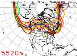 The NCEP Ensemble spaghetti plot (at left) shows the predictions of an array of computer models for the upper-level jet stream location 14 days from now, or around May 3. Each colored line represents the prediction from an individual computer model. When most of the colored lines trace a similar path, this shows an agreement in the various models - which means their collective forecasts can be trusted more that if the lines showed greatly varying paths. The NCEP Ensemble spaghetti plot (at left) shows the predictions of an array of computer models for the upper-level jet stream location 14 days from now, or around May 3. Each colored line represents the prediction from an individual computer model. When most of the colored lines trace a similar path, this shows an agreement in the various models - which means their collective forecasts can be trusted more that if the lines showed greatly varying paths.
As you can see with this graphic, the level of agreement in the different models is not very good - which is nothing out of the ordinary for a 14-day forecast. However, we can see a general shape emerging of weak troughs in the eastern and western US with an apparent ridge in the central USA. Although the western trough is normally a good feature to see, the trough is not all that amplified or 'deep' (extending far to the south). The overall jet stream is also appearing to set up well to the north of where we would like it to be for severe weather in the Plains. The pattern that the above graphic shows seems to suggest very warm temperatures across the bulk of the USA, with marginally stormy weather only in the far northern Plains for the first week of May.
Now in spite of all this, it is still way too early to judge what will happen 14 days out, even though the forecast models are beginning to reach into our storm season period. As we've said before (and experienced last year) these computer models are prone to flip-flopping wildly from day to day - so our consultation of the models now is essentially nothing more than a topic of conversation as we anticipate our departure date. However, as Day 14 becomes Day 7, then 6, then 5, then 3 - with each passing day, the information the models show us becomes more and more relevant and reliable. Furthermore, even if the above pattern comes to pass, we'll still have the whole month of May to go - plenty of time for the pattern to change to a more favorable setup.
You can follow the long-range forecasts with us by bookmarking and watching the NCEP ensemble forecasts. What we look for is a deep, strong 'dip' in the jet stream in the western USA. This pattern typically results in two major players for tornado events showing up: 1.) strong southerly winds ahead of the trough in the Great Plains, which rapidly transport rich Gulf of Mexico moisture northward and 2.) a series of upper-level disturbances and surface low pressure systems 'riding' the periphery of the trough and moving out of the Rockies onto the Plains.
GO: Home | Storm Expeditions | Photography | Extreme Weather Library | Stock Footage | Blog
Featured Weather Library Article:
|