|
Home | Blog Index | Blog Archives | Christianity & Faith Essays | Storm Chasing Essays
Storm chasing forecast update 2, for March 8
March is shaping up to be an active month for severe weather as multiple troughs (jet stream waves) move across the United States in succession. It's been one right after another, and models indicate this will continue for the forseeable future.
A "wave train" of troughs like this isn't exactly great for storm chasing. These "shortwave" troughs (smaller waves embedded in the larger-scale flow) always have southerly winds on their leading (eastern) sides, and northerly winds on their trailing sides. This means that troughs pull Gulf moisture north as they approach, then a cold front will push that moisture back south as the trough departs. The moisture is what is needed for severe thunderstorms and tornadoes. When a second shortwave follows a preceding one, its southerly surface wind component needs to bring that freshly-pushed-south moisture back north - and if those two troughs are too close together, there isn't enough time for the moisture to get back north ahead of the next one.
Such is the situation we are seeing with the next big trough shown virtually unanimously by models for the end of this week. It's a "monster" trough that has the hallmarks of a big severe weather episode in the Midwest and South, if not a tornado outbreak.
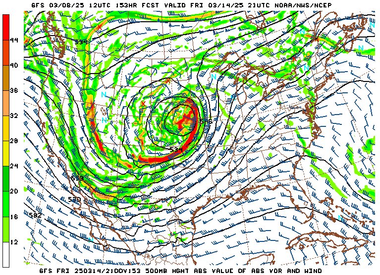
GFS 500mb forecast for Friday evening, March 14
A big trough, however, isn't a shoo-in for a huge event, even one like this can have many failure modes that lower (or eliminate) the chances for supercells and tornadoes. One such failure mode is the trough immediately preceding the big one. There isn't going to be a lot of southerly surface wind time ahead of the big trough to get the moisture back north to where the best shear is (that is, the wind profile from the surface all the way to the tropopause). Models are also differing a little on the exact timing of the big wave, which can also mean the difference between a major event and an underwhelming one. Early season troughs like these also tend to entrain a lot of clouds and produce a lot of precip on their leading sides, preventing the sun from creating the destabilization needed for robust supercells.
Right now, the best we can say is that Friday and/or Saturday *will* have the basic underlying ingredients for a tornado outbreak. But there are a few other factors that a tornado outbreak needs that we just won't know we'll have until a day or 2 beforehand, maybe not even until the morning of the event. It's also possible that the system may slow even more, placing the Great Plains in the picture of the event on Thursday. But that would leave even less moisture recovery time following the preceding wave. I probably won't have anything more substantiative to say on this system until Wednesday or so, unless all models start coming into perfect agreement before then. I think there is a high chance (>90%) this will result in at least one Midwest chase day for lightning at minimum.
The following table charts the probabilities for a Plains storm chase expedition taking place for the date ranges shown:
| 2025 Plains Chase Expeditions - Probabilities as of March 8 |
| March 8-12 | 0% | |
| March 13-16 | 30% | |
|
GO: Home | Storm Chase Logs | Photography | Extreme Weather Library | Stock Footage | Blog
Featured Weather Library Article:
|


