|
Home | Blog Index | Blog Archives | Christianity & Faith Essays | Storm Chasing Essays
February 2025 Storm Chasing Recap
Feburary was an active month, with several more winter weather trips and even two instances of lightning.
February 2025 Event List
 February 5: Freezing drizzle in central Missouri February 5: Freezing drizzle in central Missouri
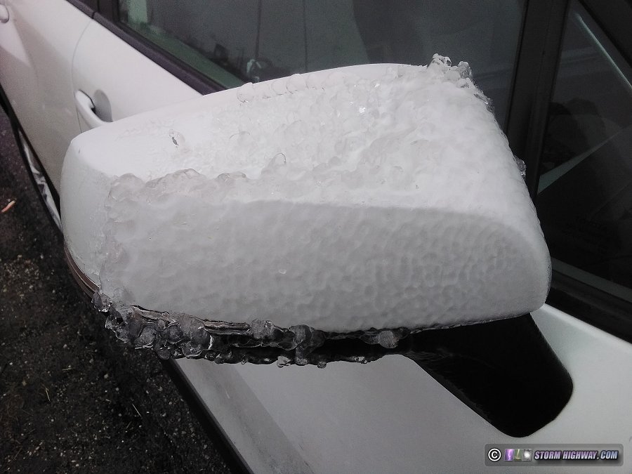
Models had locked onto this freezing rain event a week out, it was just a question of where to go for daytime impacts. Kansas City ended up being the epicenter of this one, with the bulk of the freezing drizzle occurring before twilight. I felt that a good chance for similar impacts existed somewhere in central Missouri as a combination of wet bulbing and cold advection brought temperatures to critical (29°F or below) somewhere along/north of I-70. I left home at 2AM with an initial staging target of Columbia, MO, intending to evaluate either north or west options from there. I initially decided to try intercepting the Kansas City freezing drizzle event, as I expected it to migrate east through the morning. However when I stopped for a data check in Boonville, it was clear the critical temperatures and road impact zones were not expanding east as I originally expected.
With heavier rain showing up on radar heading toward St. Louis and temperatures there within wet-bulb range of critical, I decided that the northwestern metro area would be favored for any impacts. Despite temperatures hovering right at freezing on I-70, the car was icing efficiently. The temperatures were not cooling further, though, and it appeared our chances of reaching critical temps were fading. I turned north on Highway 61 and stopped for gas at Moscow Mills. During this stop, temperatures rose from 32°F to 33°F, signalling that the model-forecast surge in temperatures from south to north was already in progress, mostly ending the threat for icy roads within my intercept range. After de-icing the car (that is, making sure there were no window-breaking chunks that could fly off), I turned toward home at 8AM.
 February 11: Freezing rain bust in Texas panhandle February 11: Freezing rain bust in Texas panhandle
The crazy winter of 2024-2025 prompts yet another winter storm trip, this time in the southern Great Plains. I left home before sunrise on Monday morning the 10th, spending the night in Vinita, Oklahoma. I awoke at 9PM to begin the drive into the Texas panhandle for freezing rain/drizzle shown by most models to occur in the early morning hours from Amarillo into western Oklahoma. I arrived there after midnight to find that no precipitation was developing, and this continued into the hours after sunrise. After finding no evidence of drizzle either observed or on radar/surface obs, I ended the day in Alanreed.
 February 12: Freezing drizzle icy bridges in Texas and Oklahoma February 12: Freezing drizzle icy bridges in Texas and Oklahoma
I awoke in Alanreed, Texas at 7PM with the plan to cover another chance for freezing rain/drizzle to develop in the Panhandle and across Oklahoma through the mid-morning hours. This time, models were more resolved with the precipitation depiction, showing (freezing rain) thunderstorms developing near Amarillo around midnight and crossing Oklahoma into Missouri in the morning hours. Colder temperatures were also in place, with everything at and north of Amarillo at critical temps (29°F or below) and Lubbock at 32°F with freezing drizzle already reported. Lubbock radar also showed a healthy shield of freezing drizzle in the area. I decided to head down there first, expecting temperatures to slowly fall with wet bulbing and continued cold advection. I encountered occasional icy bridges starting in Plainview all the way down to north Lubbock (reporting these to the NWS), stopping to film one on the northwest side of town for about 30 minutes. Salting crews eventually got all of these treated, so I decided it was time to start heading toward central Oklahoma for the winter storm's main area of precip.
By the time I was back on I-27 north, the expected storms had already developed east of Amarillo and were out of my reach, and were too far east to get ahead of. Furthermore, temperatures in the Panhandle were continuing to fall well into the critical range for road icing, and indeed, I encountered surface road icing near South Plains on my originally-planned route east through Childress. This route was a no-go: my speed would have to be kept at 30mph or below, and even that was just too risky to consider driving such a long distance on. I dropped south to Floydada on Highway 62 where I would more quickly reach sufficiently-above-freezing temperatures and therefore be able to drive at closer to normal speeds. That route would enable me to get to Oklahoma City before sunrise. The storms would beat me there by a couple hours, but I expected the main impacts to linger well into the daylight hours as temperatures were shown to cool rapidly to critical and below through the morning.
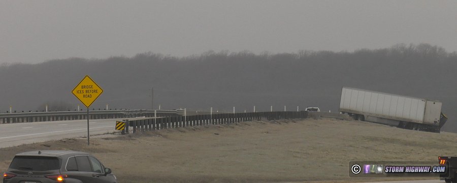
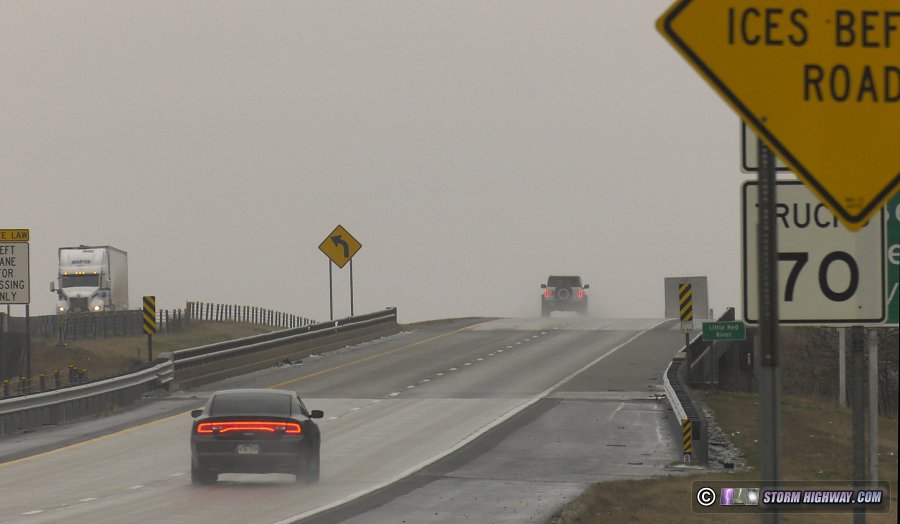
Freezing rain thunderstorms almost always contain copious sleet in their heaviest cores, and I encountered the first such swath covering the roads east of Matador. I crossed this swath again at Frederick, OK and once more at Lawton. The roads were clear north of Lawton until Chickasha, where I encountered another sleet swath. I finally reached the largest sleet swath at the Oklahoma City border at Newcastle at dawn, as a persistent freezing drizzle began. As temperatures continued falling past critical, I expected the roads to deteriorate markedly, with the worst conditions being in between the sleet swaths where pure freezing rain icing (without a sleet base) would be found. Sleet is still slippery, but it is much less slick than the treacherous pure freezing rain icing. This narrow zone of pure freezing drizzle icing was setting up from north of Chickasha through Blanchard and Newcastle into Norman. I started seeing the first spots of freezing drizzle icing on the H.E. Bailey Turnpike Spur east of Bridge Creek.
I arrived at Highway 62/277 south of Newcastle to find it completely and treacherously iced into Newcastle, with all of the bridges in even worse condition. I stopped to shoot video at a few spots here, eventually making my way south to near Blanchard where an "air hockey table slick" set of Highway 62/277 bridges was causing loss-of-control incidents. I stayed here shooting for almost 3 hours before the DOT crews finally got the highway treated. I could not launch my drone during my first 30 minutes at this spot, as the closest ASOS at Norman showed 1-mile visibility (you need 3-mile visibility to fly a drone legally). As time went on, the Norman ASOS continued showing fog and low visibility, but the nearby Chickasha ASOS showed 7-mile visibility with my location clearly well over 3 miles (I included a shot of the visibility conditions at my location at the end of the video below, just in case there are any questions about that). After that 30 minutes, I finally was confident enough that visibility was well over the required threshold, so I was able to get the drone up and shooting for a couple of hours:
After this stretch of highway was treated just before noon, I began the drive home, stopping in Chandler to edit and feed out the video once the initial backup-to-hard drive operation was completed. I used to edit directly from the SD cards, but after the Florida data loss incident, I'm backing everything up to hard drives first from now on. It adds another hour or so to my process, but it has to be done.
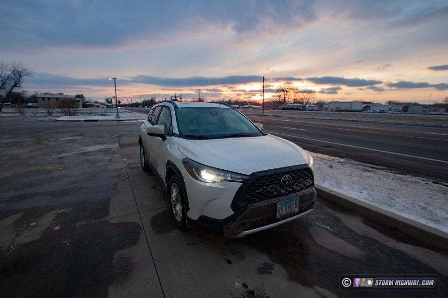
I knew I would cross my career 400,000 mile mark on this trip, which my mileage records showed would occur somewhere north of Tulsa on the Will Rogers Turnpike (I-44). With no safe places to stop on that highway, I chose to instead take old Route 66 through Claremore to Vinita so I'd have a safe place to pull over at that moment. I reached the 400,000 mile mark in the town of Chelsea, stopping to grab a shot of my car for posterity at sunset along Route 66:
I continued to Vinita for the night, ending another 24-hour winter storm coverage day (as they typically are required to be). I made the rest of the drive home the next morning.
 February 14: Freezing rain thunderstorms in the St. Louis metro February 14: Freezing rain thunderstorms in the St. Louis metro
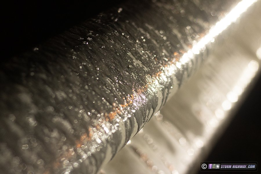
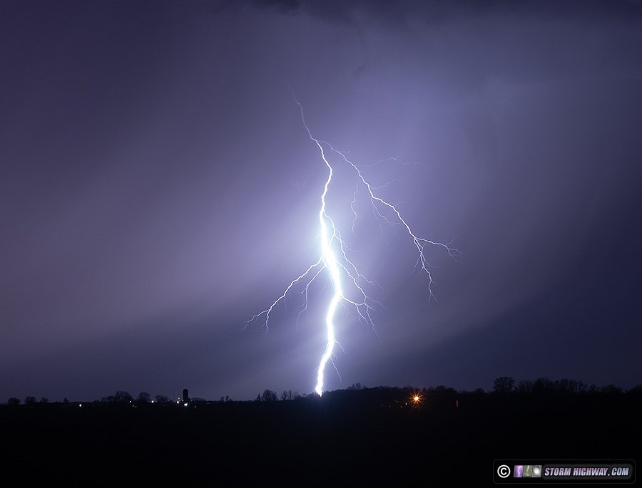
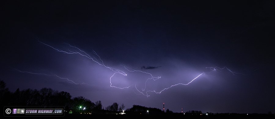
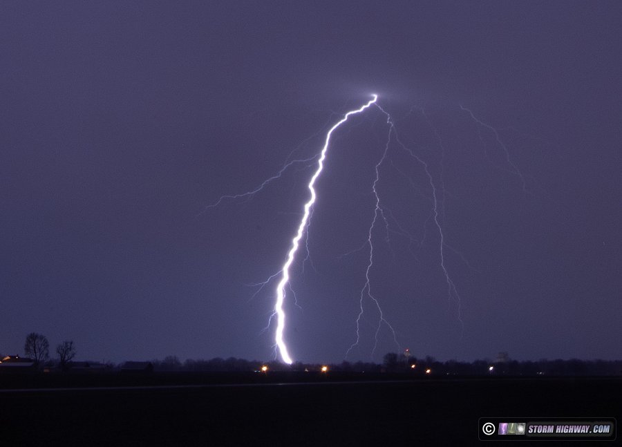
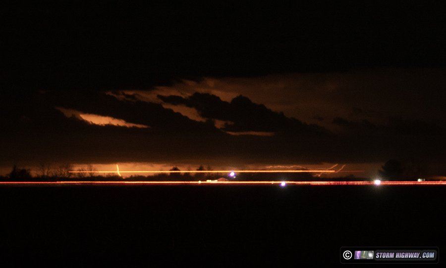
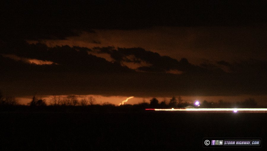
Quite the unexpected show tonight! Models indicated rain falling in borderline freezing temperatures with dewpoints in the teens, meaning wet-bulbing was going to threaten a freezing rain icing event in the St. Louis metro this night. When the expected showers developed, they were surprisingly convective, with large raindrops typical of thunderstorms. And sure enough, it wasn't long before the lightning started flashing. By 10pm, there were maybe a dozen cells in the region producing bolts. I chose the closer ones passing near Highland, simultaneously keeping an eye on how the icing situation was evolving. Temperatures were 35°F and dewpoints in the teens, meaning well within the range to wet-bulb below freezing. Accordingly, temperatures fell to 34°F quickly and my car began icing from the rain within minutes. I was not, however, finding any issues on roads or bridges other than a non-slick coating of light sleet near I-70 from the heavier thunderstorm cores. I did not venture farther north where temperatures were colder, but traffic maps showed icing was likely impacting I-72 and the Springfield area. Guardrails and signs were icing areawide - this is a guardrail at I-70 west of Highland:
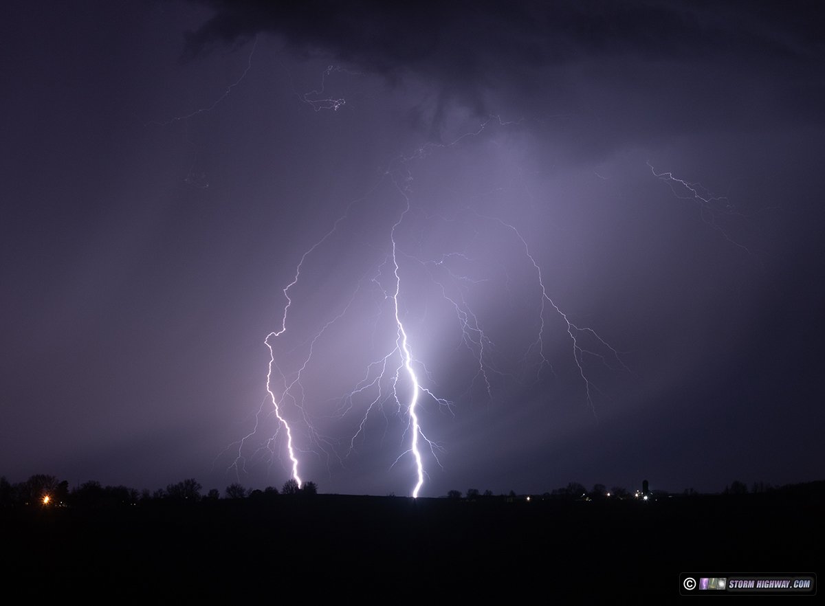
The storms were moving at blazing speeds, possibly faster than 70mph. This improves the lightning photography prospects because the cells are literally outrunning their own precip cores. This results in the bolts landing mostly ahead of the rain into clear air. These photos show how tilted the rain shafts are, thanks to the extreme speeds the cells are moving in the fast upper level winds.
These bolts were captured between Trenton and Highland. This was the coldest weather I'd ever shot lightning in before (34°F). I had to put on my cap and gloves! It was also the most photogenic cold weather lightning I'd seen, the visibility of the bolts was on par with a spring or summer event!
This flash was also captured on the high speed camera at 6,000fps.

 February 15: St. Louis overnight snow February 15: St. Louis overnight snow
This wasn't expected to be a major event or even have much of any impact, but precip and critical temperatures together always mean the chance for an icy road event that warrants monitoring. Even though I've mostly given up on nighttime video shoots (night videos never perform well, even if I capture compelling shots), this was close enough to go out for a while and take a look.
This event overperformed expectations. I got off of work at 11:00pm to find new snow bands developing right over the metro area. These quickly covered all roads, with bridges in slightly worse condition. I went up to St. Charles initially, spending about 2 hours there before moving south and east with the heavy snow into Mehlville. I wasn't finding much happening, so I headed home at 2:30AM. Surprisingly, Illinois' roads were in worse shape on my way back, particularly east of Highway 4. Again though, with the nighttime hour, the brutal cold/wind coupled with the fact that I had to work Sunday and Monday and needed to sleep, I decided to call it a day. Between my normal job and this relentless winter weather, I haven't had a real day off since the beginning of the year. The next big storm was looming on Tuesday and Wednesday, so I need all the rest I could get.
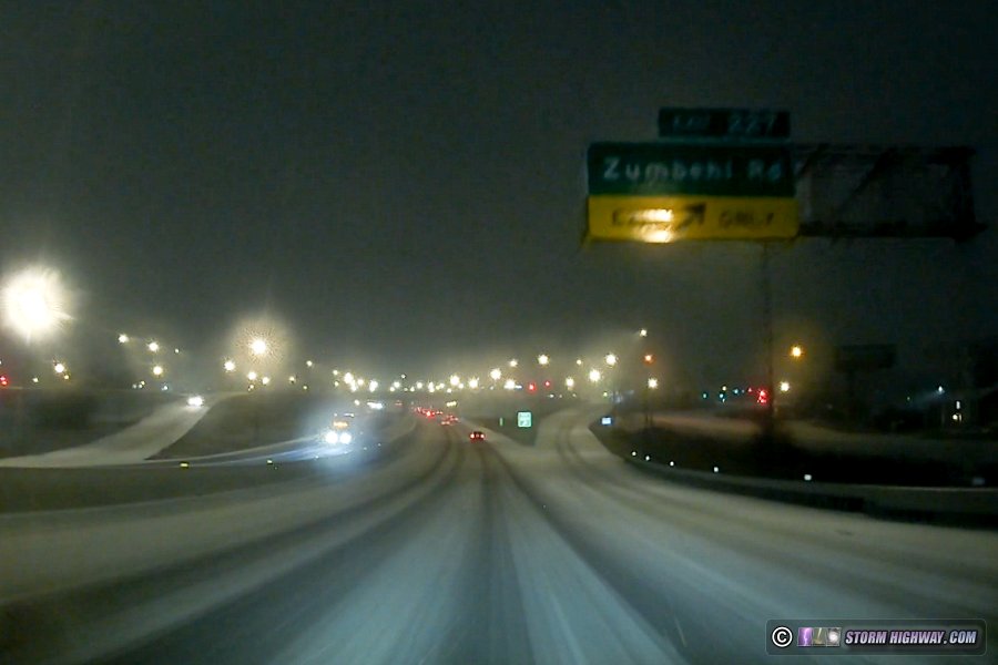
I-70 at Zumbehl in St. Charles
February 18: Oklahoma & Arkansas freezing drizzle & freezing rain
The plan for yet another big next winter storm trip was the usual: focus on the freezing rain aspect from Oklahoma through Arkansas. I left Monday morning with a stop for the night at Vinita, OK. I awoke at 11PM and headed down to the Tulsa area to await the development of the primary area of freezing rain between Oklahoma City and Tulsa after midnight. This started at around 4AM, quickly icing the roads in the area. Salting and plowing crews had a good handle on the worst area such as bridges and hills. At daybreak, I headed south on Highway 73 through Okmulgee to Henryetta. Here I encountered treacherous icing on all road surfaces, but the main things happening were semi trucks already stuck on the hills and unable to move. This resulted in parts of the highway being shut down. At Henryetta, fast-moving westbound traffic was encountering the first icy bridges after crossing the freezing line. This jackkife had already occurred before I arrived, but the highway leading up to it was also treacherous:
DOT crews got this area salted after about 15 minutes, so I headed northeast to Muskogee where the critical temparature line was arriving. By the time I got there, the changeover to sleet had already started at the same time as the critical temperatures did. This meant there were no more pure freezing rain areas in critical tempratures within my reach, mostly ending the most severe phase of the icy road event.
I began the drive home on I-40 in order to circumvent as much as the snowstorm to the north as possible. My transit across Arkansas was at 31-32°F, which meant the roads were in good shape, but my car was icing heavily. As soon as I crossed back into critical temperatures at Searcy, I encountered a couple of icy bridges on I-57 causing loss-of-control incidents. I stopped at one for about 15 minutes until salting crews got them treated.
After this, the precip type changed to sleet, then snow just before sunset, putting an end to the storm's worst daytime icy road impact phase and making this one of the many trips where no usable footage was captured. I made my way east and north through the developing snowstorm to I-55, then north to Osceola where I stopped for the night. I arrived home at 10AM Wednesday.
 February 26: Southern Illinois distant lightning February 26: Southern Illinois distant lightning
Models showed the potential for thunderstorms at or near the southeastern St. Louis metro area along a cold front this evening. Storms fired before sunset about 50 miles southeast of New Baden, and the lightning was visible once darkness fell. I went out for about 30 minutes south of town to fire off a few frames with the 50mm lens. Clouds blocked my view of the more active, but more distant, cell to due east. This second storm was over 70 miles away to the south-southeast near Goreville, south of Carbondale. It was less active than the other one, but it produced a few visible bolts:
< January 2025 Recap | All Storm Chase Logs | March-April 2025 Recap >
GO: Home | Storm Chase Logs | Photography | Extreme Weather Library | Stock Footage | Blog
Featured Weather Library Article:
|


