May 23, 2005: Still watching, waiting for June
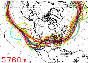
 Just another quick update to comment on the latest model forecasts. With the ridging/northwest flow pattern persisting on the Plains, storm photographers currently in Tornado Alley are finding slim pickings in the way of severe storms. Thunderstorm activity has been able to develop this week, but very few events have been friendly to the storm photographer. So, we've not been missing much by postponing our trip. The latest long-range model runs are still pointing to a trough developing in the western USA (image at right) after the Memorial Day weekend. If this comes to pass, the outlook will improve for severe weather and tornadoes around June 1 and beyond. Just another quick update to comment on the latest model forecasts. With the ridging/northwest flow pattern persisting on the Plains, storm photographers currently in Tornado Alley are finding slim pickings in the way of severe storms. Thunderstorm activity has been able to develop this week, but very few events have been friendly to the storm photographer. So, we've not been missing much by postponing our trip. The latest long-range model runs are still pointing to a trough developing in the western USA (image at right) after the Memorial Day weekend. If this comes to pass, the outlook will improve for severe weather and tornadoes around June 1 and beyond.
If you've been following along with our commentary, you know that these model forecasts can change quickly, leaving all hope in the dust. Or they could verify, giving us what we've been looking for. It's a waiting game on the roller coaster of uncertainty that is storm photography.
Lastly, I finally developed cold symptoms on Sunday (after over a week since exposure), so it looks like I didn't escape the bug after all. The good news is that I'll likely have time to let the worst of it run its course before we depart again on Friday or Saturday. We'll be looking hard at available data early this week in order to make a final decision on departure for Memorial Day, that is, if our work schedules can be rearranged.
GO: Home | Storm Expeditions | Photography | Extreme Weather Library | Stock Footage | Blog
Featured Weather Library Article:
|