
|
||||||||||||||||||||||||||||||||||||
VIDEO: Kankakee tornado: timelapse from start to rain-wrap KANKAKEE, IL - I observed four tornadoes from Pontiac, Illinois to near Knox, Indiana on Tuesday, March 10, including a significant tornado on the south side of Kankakee. This is the log of the day's chase. This event had been looking like a near-100% Midwest chase day for around a week prior. Like most Midwest setups, the warm front was the place to be for tornadoes. Models mostly agreed this would be somewhere around central and northern Illinois by storm time. St. Louis was also shown being far outside of the risk area, quelling my usual fear of missing something big at home. The task as a chaser was to figure out where a storm would not only encounter the vorticity-rich (lots of ambient spin) frontal zone, but be in it for the longest amount of time. This means the orientation of the front needs to be at the optimal angle for this. If the front is perpendicular to the storm's motion, the storm will cross the front with a only very brief window to produce a tornado. Too much of an angle in the other direction results in the storm never encountering the front. If it is more parallel to the storm's motion, the storm will be in the frontal zone for much longer, providing the best chance to produce a tornado.
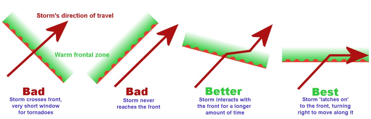 The angle between storm motion and the orientation of the boundary is a critical factor in tornado risk. The angle between storm motion and the orientation of the boundary is a critical factor in tornado risk.The absolute best configuration for a warm front is one where it is at a 20 to 40 degree angle to the storm's motion. This will maximize the chance that the storm will not only encounter the frontal zone for a long time, but it will often 'latch on' to the front and actually track along it. This is called 'deviant motion' when a storm latches on to a boundary (outflow boundary or front) and changes direction away from the upper-level winds. This increases the storm-relative helicity (SRH), a measure of the angle and strength of the inflow flowing into the updraft (relative to its motion). Storms that do this usually become 'tornado machines' for hours. The analogy for this phenomenon is like riding a bicycle across railroad tracks: cross the tracks at a right angle, and you go right across safely. Cross it at a little too close of an angle, and your front wheel will drop into the gap along the rails and yank you in the direction of the track. So chasing a warm front means being where the boundary is oriented favorably for a storm to "grab it" with the maximum amount of deviant motion it can, without crossing the boundary into the colder air. Models were having a lot of trouble with where this would occur, not even agreeing much on how far north the warm frontal zone would get. Warm fronts move in a northerly direction, and the best angle will usually- but not always- be on the front's eastern side. Models indicated this would likely be in northeastern Illinois into northern Indiana. Complicating the day's forecast was the lake breeze from Lake Michigan. The lake breeze is a frequent player in northern Illinois severe weather. It can move far inland, acting just like a cold front as it does. Thanks to the lake still being very cold from the long winter, models increasingly showed that the lake breeze this day would travel very far inland, reaching the eastern side of the favorably-oriented warm front.
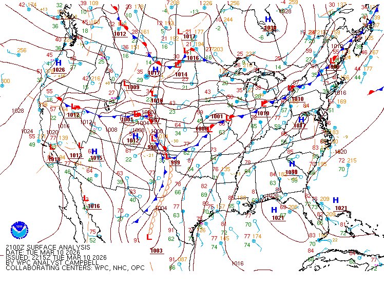 WPC surface analysis for 4pm, showing that the warm frontal portion of the boundary has been overtaken by the lake breeze (shown here as a segment of cold front). WPC surface analysis for 4pm, showing that the warm frontal portion of the boundary has been overtaken by the lake breeze (shown here as a segment of cold front).Models indicated that supercells could develop early and be tornadic as early as 3pm. This meant I had to leave at 10am to ensure I made it in time. My target was the eastern warm frontal zone, where most models showed a storm encountering the front at the best angle. But there was a pretty wide area where this might happen - pretty much the entirety of northern Illinois from the Indiana to Iowa borders. Furthermore, the very cold and potent lake breeze was already moving inland toward the warm front at a good clip, appearing like it would reach it easily. If that happened, the more favorable eastern frontal zone would get completely trashed. Accordingly, I stopped at Chenoa and pondered the decision: east or west? These areas looked too far apart to hedge in between them, so I had to pick and commit to only one.
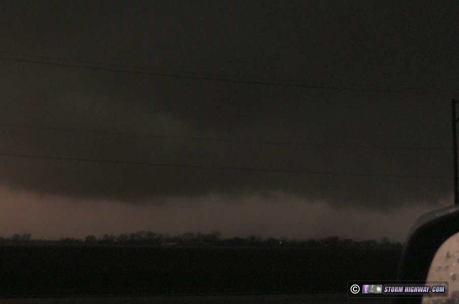
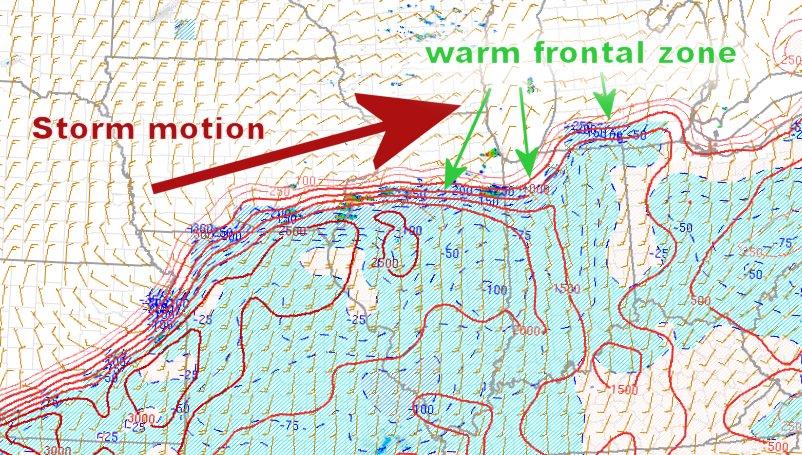 Surface-based CAPE (instability) on the SPC Mesoanalysis Page helps to identify warm front orientation in real time. This chart showed the eastern part of the frontal zone would provide the angle with the maximum amount of deviant motion for a supercell interacting with it (without crossing it). Surface-based CAPE (instability) on the SPC Mesoanalysis Page helps to identify warm front orientation in real time. This chart showed the eastern part of the frontal zone would provide the angle with the maximum amount of deviant motion for a supercell interacting with it (without crossing it).By 2PM, agitated cumulus was starting to build along and south of the front from Peoria to the Indiana state line. Cumulus fields on visible satellite are a vital indicator of where a storm will form, becoming agitated in places where a storm development is imminent. This eventually became focused near Peoria, so I made the final call to head west to meet this storm. It would only be along the frontal zone for a brief time before encountering the lake breeze, but it looked like the most favorable of the other locations. Furthermore, models agreed on the southerly surface winds increasing to the point that they would start pushing the lake breeze cold front back north - as a warm front - close to sunset. I was due north of the storm near Washington, IL when it first formed, and moved over to El Paso to intercept. It had a large and healthy base, and all signs pointed to it intensifying further: growing VIL core, strong inflow, plenty of instability and the warm front just ahead. I stair-stepped on the very nice Illinois rural (mostly paved) road grid to stay with it. I clipped the edge of the hail swath several times, where nickel and half-dollar sized hail was scattered around. River and interstate highway crossings in Illinois are few, and require advance planning. They both are similar obstacles to a chaser. Many times you need to leave a storm and go a good distance either south or north to the first available crossing. Getting behind a storm is a bad thing, and is usually something to be avoided. So, my typical strategy is to get farther ahead of a storm at these crossings to ensure I make it in time. You risk missing something doing this, but if you stay with a storm right up to the river or interstate, you'll have to leave it for the same or even longer amount of time - and then even worse, you'll be behind the storm afterward. I-55 at Pontiac was the first of these crossing points. Thankfully, the best crossing point was at the northern Pontiac exit, and I made it back into position just northeast of town. While I was doing this, the storm's low-level organization increased markedly. A large, strongly-rotating wall cloud formed just west of the interstate, heading directly for Pontiac.
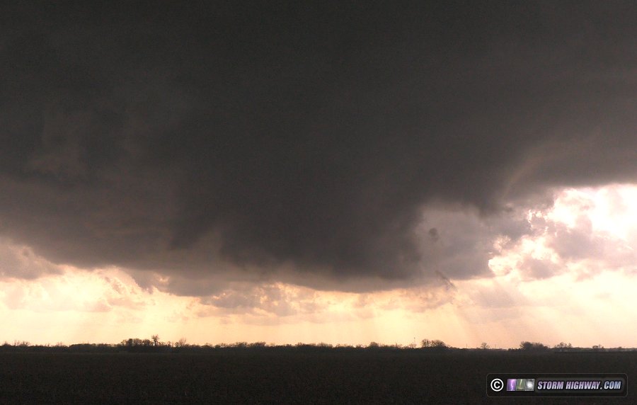 My heart sank. It appeared I was about to witness yet another destructive tornado go through a populated area. Many of my bigger intercepts in the past 2 years have been tornadoes that were both killers and mass-distruction producing, ruining the sense of awe and wonder you usually feel when watching them (and remembering the experience). The debris cloud appeared as a broad circulation with several subvortices:
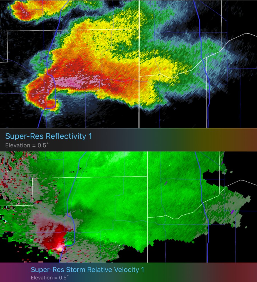
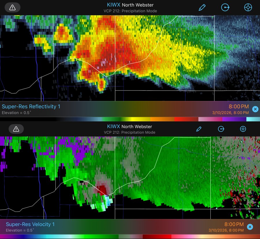
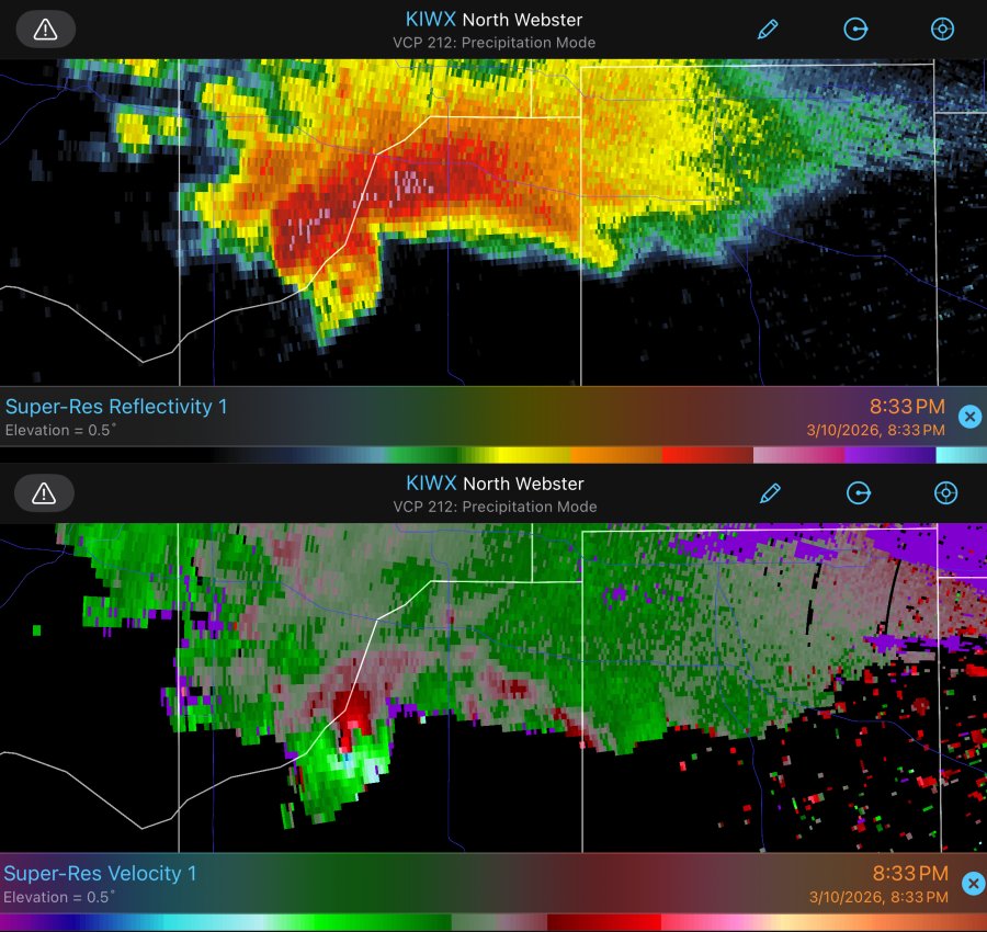
 Radar at this time:
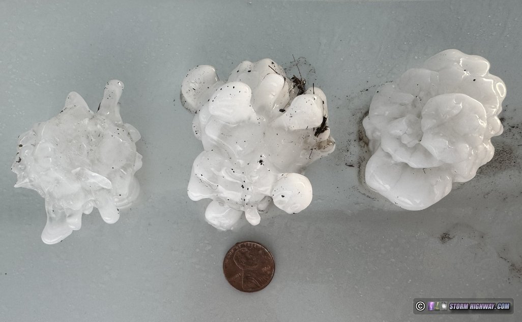
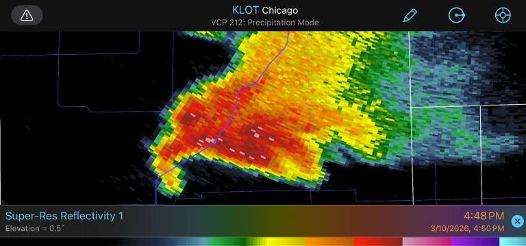 Radarscope As this continued, I breathed a sigh of relief. It was now clear it had started just outside of town, and was moving away from it. Counter to my expectations, the tornado did not last long, only a minute or two. As I resumed the stair-stepping on the road grid, this circulation fully occluded, beginning to shrink and move off to the north. Normally at this point, you turn your attention to the storm's next cycle developing to the east as the first one dissipates and curves north. But despite radar showing a broad mesocyclone, there was no lowering or visible rotation associated with a new cycle. I started feeling cool northerly winds, and the storm's organized appearance faded. This indicated that the storm was likely across the lake breeze boundary and was now 'elevated'. An elevated storm means that its updraft is overtop of a shallow layer of cold air at the surface, and is pulling its inflow from the layer of unstable air well above the surface. Tornadoes need the storm to be ingesting inflow all the way down from ground level (what is called 'surface based'). I considered leaving the storm and bailing to the next supercell to the distant southwest. But, it would be close to getting dark by the time I would arrive on it. Furthermore, the models did agree on the lake breeze getting pushed back north as the low-level jet began to ramp up. If the storm could manage to stay alive long enough for that to happen, it would likely resume its tornado threat. I kept moving north with the storm, again crossing the hail swath a few times. I stopped once to take a look at the larger spiky hailstones that were exceeding 2 inches:
 A wind farm just to my south was instrumental in revealing what was taking place at this time. Wind turbines automatically rotate to face the wind when it changes direction. This means they are essentially a 'micro-mesonet' showing what the low-level winds are doing near a storm, at a very detailed scale. The closest row of turbines were facing north, in the direction that the cool northerly lake breeze/outflow was coming from. The second row were facing east, indicating that they were either on the boundary in easterly winds, or they were halfway in the process of turning to face either north or south. All of the turbines beyond the northernmost two rows were still facing south, showing that the warm, moist air was not very far away. Finally, some of that last row of turbines began to turn back to the south, revealing that the low level jet was winning the battle against the lake breeze.
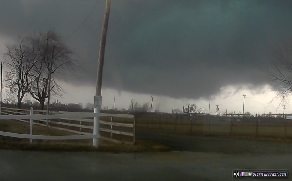
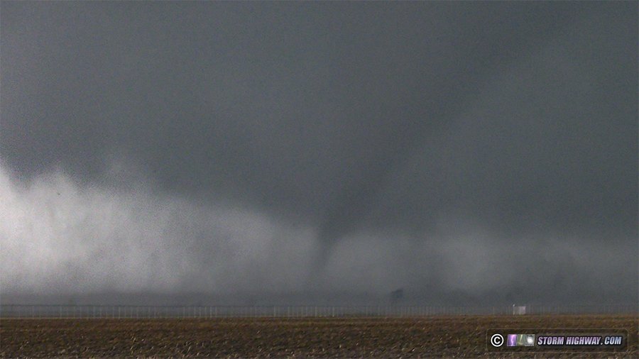
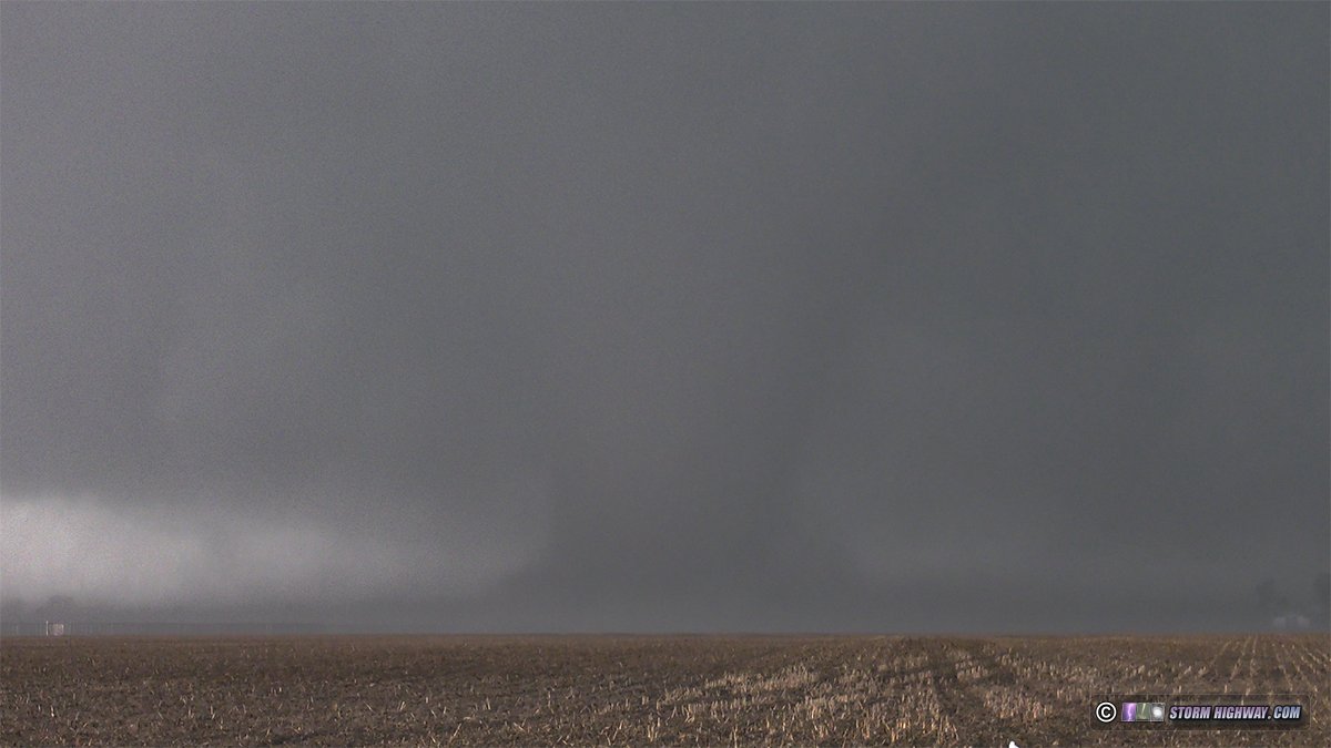
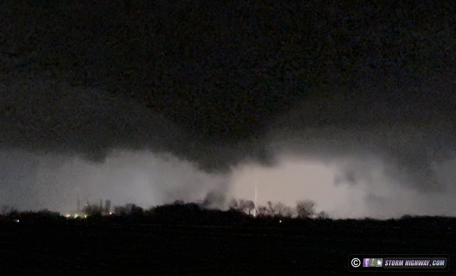
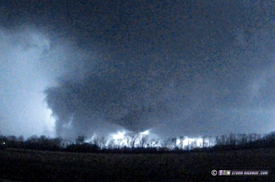
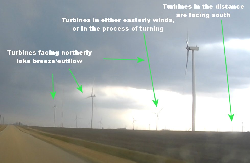 A wind farm is a micro-mesonet, allowing a visual on what winds near a storm are doing. A wind farm is a micro-mesonet, allowing a visual on what winds near a storm are doing.Shortly thereafter, the storm began a rapid intensification near Herscher. The warm air on the southerly winds had not only reached the storm, it was screaming into it stronger than at any point previously. Lowerings began appearing and a broad mesocyclone became apparent on radar. The storm, that had been moving east-northeast, turned hard right to move due east. It was now in the frontal zone and had 'latched on' to it. This intensification continued, with rotation now very visible and a RFD clear slot wrapping completely around an intensifying circulation. A tornado looked like it was minutes away west of Kankakee. But I had a problem now: the I-57 crossing was just ahead, and I didn't have a bridge across at the road I was on. I would need to go either 3 miles north to the first Kankakee interchange, or 5 miles south to the first crossing in that direction. The northern crossing was closer, but was very close to the storm's hail core. With some trepidation, I chose the northern route. My original plan here was to do the usual: cross the interstate and the Iroquois River to stay ahead of the storm on the east side of Kankakee. But as I crossed over the interstate, I could see a tornado was either already in progress, or seconds away - just to the west. The process of getting ahead of the storm here would make me miss what the storm was about to do - and it looked like it was about to do something very big. Forfeiting a good position ahead of the storm is worth it if it is producing a significant tornado right there. Just south of the I-57 interchange, I stopped to face the meso to the east. The tornado had, in fact, already developed. A debris cloud was visible, and a narrow funnel quickly appeared and lowered most of the way to the ground:
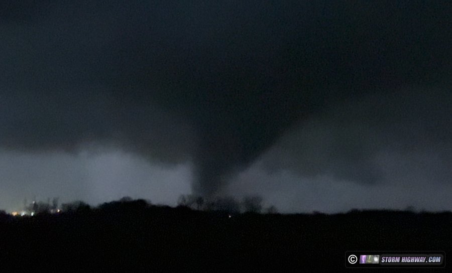
 I went back north a short distance to get closer. The tornado, in bowl funnel form, was beginning to cross the interstate. It was also now audible:
 As the debris cloud entered the field and grew larger, I felt I was too close. I turned around and headed a short distance back south and turned east on the road to the Kankakee airport. This turned out to be a good decision, as the RFD closer to the tornado was filled with baseball-sized hail which broke some chasers' windows. The tornado rapidly fully condensed into a large cone. The airport road was in a good viewing position, but the tall perimeter fence ruined my shot. There wasn't anything I could do about it. While this airport didn't have a Class B, C, D or E airspace restriction, I think that flying a drone right next to an airport - even if it's not illegal - is just asking for trouble.
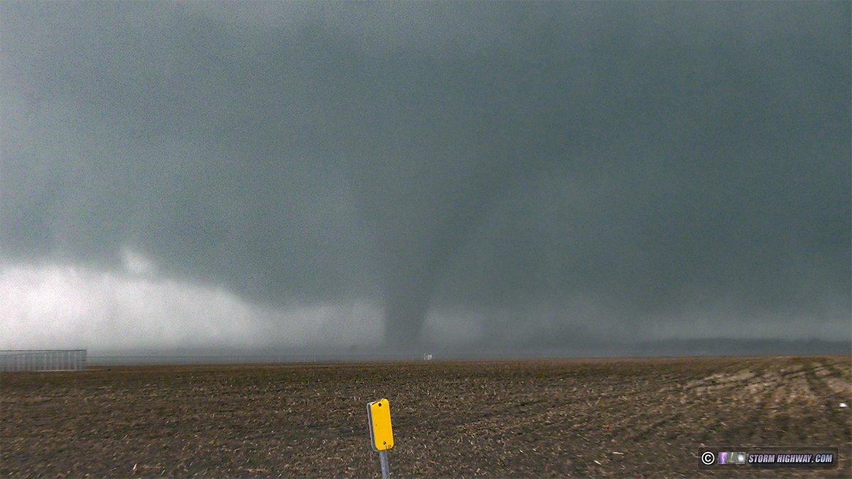
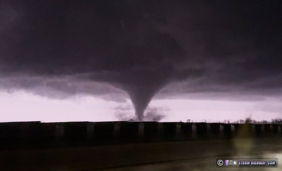
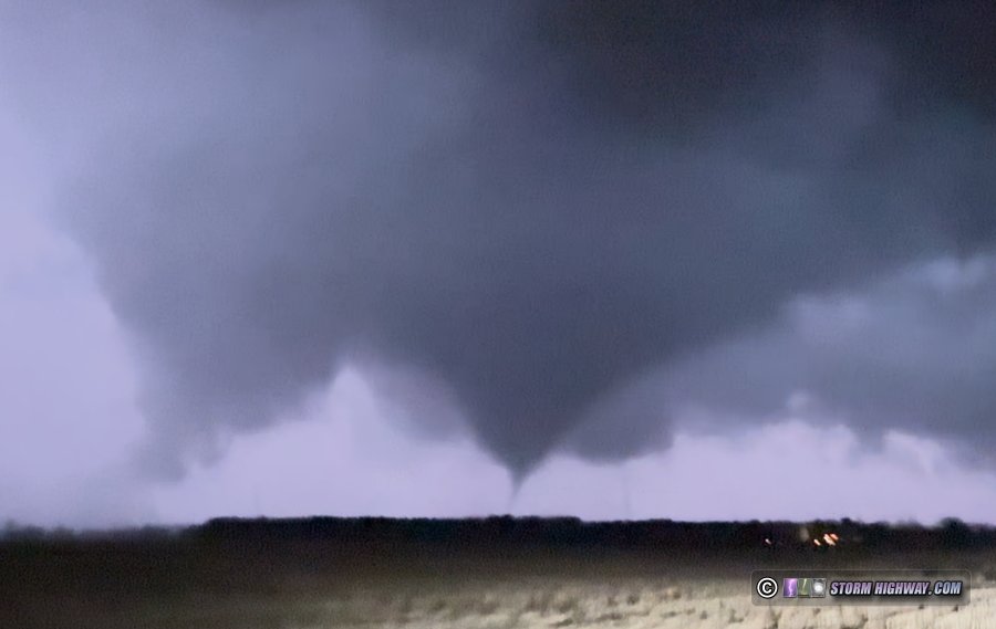
 As the tornado continued east, I moved down past the end of the airport property where there was no fence. I had a great view here, but the wrapping rain in the RFD was starting to envelop the tornado as it fully condensed again:
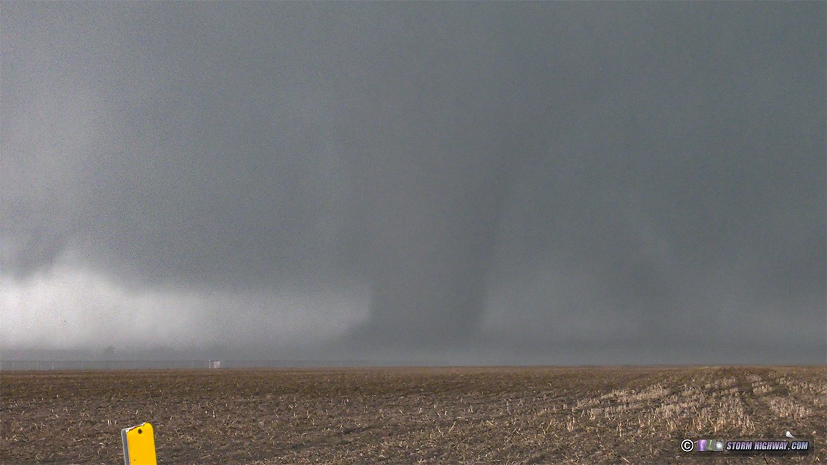
 Its most dramatic form was this fat barrel reminiscent of the later stages of Bridge Creek, Oklahoma on May 3, 1999. Unfortunately, the increasing rain wrap had reduced the contrast considerably:
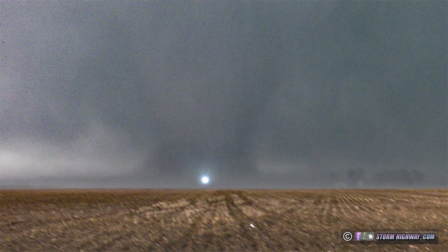
 Power flash:
 Radar at this time:
 Radarscope A few seconds later, the tornado was completely rain wrapped. It was time to continue east, but I was now behind the storm and out of position. Furthermore, there was still another obstacle to contend with: the Iroquois River. I only had a bridge about 5 miles to the south, and a closer one a couple of miles north. The tornado's damage path was likely over, or just south of, the northern bridge. Fresh tornado damage is hazardous to drive through for both you and your vehicle, and there was a good chance for the road to be blocked with debris. So I considered that option out: all I had was the southern bridge. As it turned out, getting ahead of the storm via the northern bridge would have been impossible anyway. The storm's hook (see the radar image above) was full of softball-sized and larger hail. There would have been no way to punch through that without destroying all of my windows! As I expected, getting back ahead of the storm took a very long time. Catching the Kankakee tornado had cost me my good position on the storm. It would be the last daytime view of a tornado I would have on this chase. As I made my way east about 7 miles to the south of the storm, it appeared with every glance at the radar that the storm was producing multiple strong tornadoes in a cyclic sequence. I had no hope of seeing any of them, as they were all heavily rain wrapped from the south view.
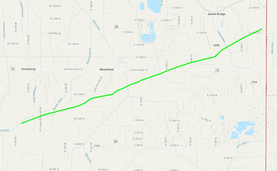
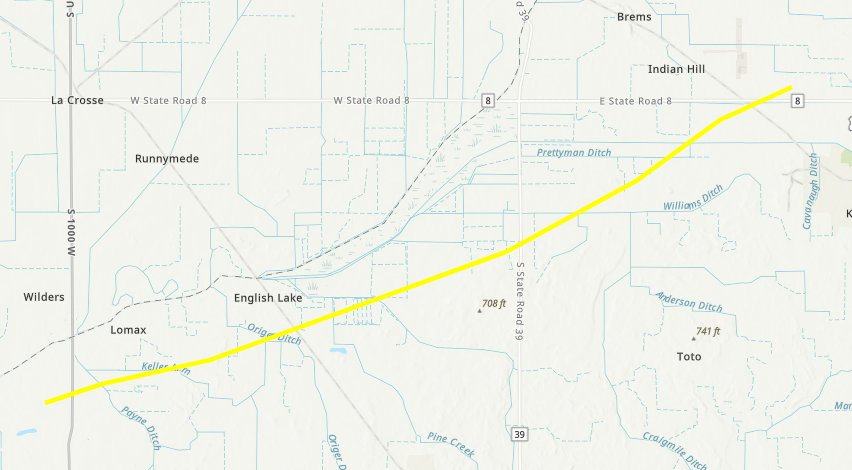
 As it turns out, this was all the same tornado and was officially rated EF3. The NWS Chicago's (LOT) damage survey showed a continuous 36-mile path from west of Kankakee all the way past the state line to Roselawn, Indiana:
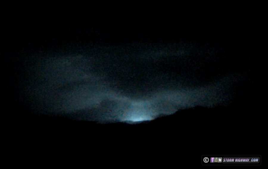
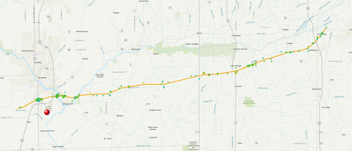 The red dot is my viewing location at the airport. Note that the path line on this map doesn't show the width of the tornado. You can get an idea of that by looking at the individual damage sites (noted by the colored triangles). From the imagery from others I've seen so far who were in a good position on the storm during this time, the supercell was very HP (high precipitation) and the views of the middle and later stages of the tornado were poor. So as it turned out, I managed to catch the tornado when it was the most visible. Storm chasing is like that sometimes. You have to make a choice that can make or break the day. Sometimes it works out like this, sometimes it doesn't. If you've read very many of my past chase logs, you've seen that I've been on the other side of that countless times. I finally got far enough east of the storm's longitude after crossing the Indiana state line - well after dark - and made my way north on Highway 41 toward Lake Village to re-intercept. However, the RFD precip beat me across the road, forcing me to go east again. I made this type of attempt a couple more times. Up until this point, the storm had been heavily HP since it moved east of Kankakee. But at Kinman, IN, the lightning flashes revealed a large rain-free base with an ominous lowering to the north. This meso cycle was 'classic', meaning that you have a clear view of what the storm is doing. Radar velocity showed there was a very strong circulation present, and based on the storm's history, I expected a tornado to already be in progress. Sure enough, as I turned east at Kinman, power flashes lit up to the north. Lightning flashes revealed a large funnel with a debris cloud underneath near Wheatfield, Indiana. This strong tornado intensified and fully condensed intermittently, the lightning behind it providing a great view:

 Radar at this time:
 Radarscope NWS Chicago (LOT) surveyed and rated this tornado EF1:
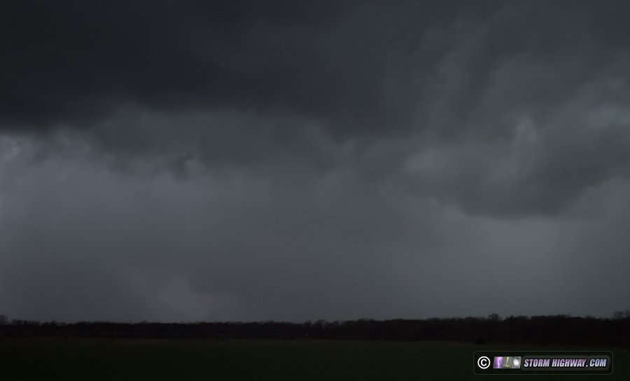
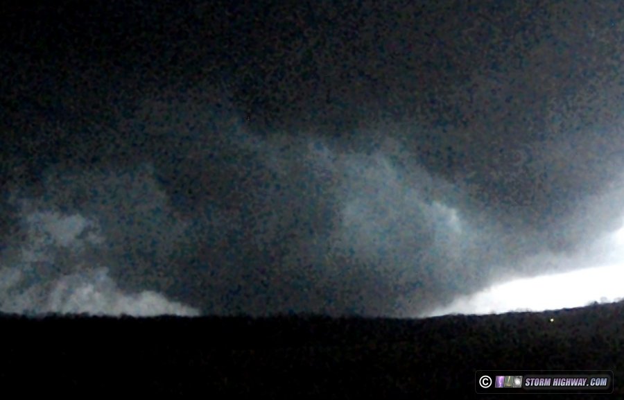
 This tornado appeared to never get rain-wrapped, dissipating before the heavier RFD precip made its way fully around it. The next meso cycle then appeared to the north. My next north-to east stair-step would be very close to where the Wheatfield tornado tracked, so I made the north leg more slowly in case there was sudden debris or wires down in front of me. Lightning flashes illuminated another bowl funnel, signaling the newest cycle was already producing:
 This part of Indiana is more forested than farther west, so open views were harder to come by. I managed to find a spot to watch the next tornado, near Toto, Indiana fully condense briefly. I could also hear it:
 As I moved east to stay with this, spotters were reporting this tornado had rapidly grown into a wedge (unbeknownst to me at the time), triggering the issuance of a Tornado Emergency for the town of Knox. I did not witness this, thanks to the very brief gaps in the trees and focusing on the road. I went back through my driver's side dashcam and found it captured this lightning-illuminated frame of the tornado in its wedge state:
 Radar at this time:
 Radarscope NWS Northern Indiana (INX) surveyed and rated this tornado EF2:
 About 5 minutes later, a long burst of power flashes illuminated the (now smaller) tornado for about 25 seconds:
 The tree situation worsened the farther northeast I went, so I initially could not get a good look at the storm after the tornado emergency was issued for Knox. I finally found a view south of town, but could not see any definitive storm structure. The couplet on radar had faded, the hook became less defined and the VIL core continued to shrink. It looked like the storm's tornadic phase had ended and its dissipation phase was beginning. I decided it was time to begin the five hour drive back home. I took I-55 back south rather than I-57 so I could get a look at the final round of storms moving through western Illinois on my way home. These were not producing much visible lightning, so I didn't stop for any of them. As I passed Bloomington, a QLCS-type tornado warning sounded for a storm to my due west. I was within intercept range of it, but didn't think I'd be able to see anything even if it did manage to last long enough to its I-74 crossing point. I arrived home at 3am to bring the 15-hour, 778-mile chase to an end. I later learned that the Kankakee tornado had sadly taken at least 3 lives, maintaining the somber trend of the past 3 severe weather seasons.
GO: Home | Storm Chase Logs | Photography | Extreme Weather Library | Stock Footage | Blog
Featured Weather Library Article:
|
||||||||||||||||||||||||||||||||||||


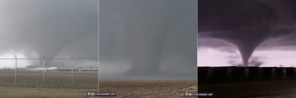 ABOVE: Tornadoes in Kankakee, Illinois and Wheatfield, Indiana on March 10, 2026


Web Site Design and Internet Marketing by CIS Internet