|
Storm Chasing Home | Tornado Intercepts | Storm Chasing FAQ | Expeditions by Year | Video Clips | Photo Gallery
April 24-25, 2009 Storm Event Log

Click any photo to enlarge
Plains 2009, Day 1: Friday, April 24, 2009
Some of my Plains trips happen like this - one minute I'm not going anywhere, the next minute I'm on the way to Oklahoma. Literally! Such was the case this time. Matt (my brother, in Raleigh, NC) had been planning on heading to the Plains with me sometime in May, and we had been talking about leaving to pursue the upcoming trough forecasted by the models for the week of April 27 and beyond. There were some good setups already happening over the weekend (the 25th and 26th), but my parents were visiting Matt and Beth in Raleigh over that weekend, so the earliest Matt could leave was Tuesday the 28th. That was the tentative plan anyway (chasing plans are ALWAYS tentative, by the way). As the weekend approached, the models kept showing the active pattern happening later in the week. With Matt having to work that next Saturday the 2nd, unfortunately that meant he wasn't going to be able to go this time. I had that phone conversation with him on Friday afternoon. Before that, I was thinking we'd be leaving on Tuesday. After the phone call, I decided that since I wasn't going to need to wait until Tuesday for Matt to be able to leave, that I'd jump on the weekend setups in the Plains. I literally hung up the phone, walked back to the parking garage to pick up my truck (I was at the office downtown), ran home to get some clothes and a toothbrush, and was on the road westbound 30 minutes later!
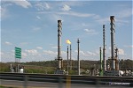
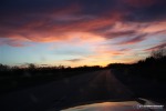
Heading west on I-64 in the spring is one of the great joys of my life. This was the 18th time in 9 years I've began that drive to the Plains (I've also driven I-64 many more times for midwest and Kentucky chases). While not much changes from year to year, I usually shoot a few photos on the way of just for the memories of each trip. Here are a couple. The first shot is the refinery at Catlettsburg on the KY/WV state line. The stack flames were pretty big today. When I was a kid, we'd pass this plant on the way to visit my Aunt Edie in Ashland. The flames were almost always being flattened sideways by the wind, so we always called this landmark the 'flat fires'. The second photo is the spectacular sunset driving west on I-64 near Corydon, Indiana. I almost always leave Charleston for the Plains in the afternoon, meaning I usually see sunset somewhere in Indiana or Illinois.
I passed through St. Louis just before midnight, stopping for some QuikTrip eggrolls, a storm chase expedition favorite! For those of you back east, QuikTrip is a midwestern convenience store chain in some of the larger cities that blows anything we have east out of the water. The place is usually very clean and has a big hot food and drink bar, including these egg rolls that I have to stop for every chance I get. QuickTrips are all over St. Louis and Tulsa. Too bad this type of thing can't catch on back home - our convenience stores here are places I avoid unless nothing else is open.
I started feeling a little tired near Springfield, so I parked on an onramp among some 18-wheelers to get a few hours of sleep. Onramps are my new preferred 'vehicle lodging' spots, they are safer than rest areas, and with the big trucks around, not much of a chance of being bothered. Some states don't allow this, but thankfully Missouri does as I'm usually ending up making my stopovers there.
Day 2: Saturday, April 25, 2009
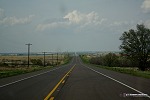
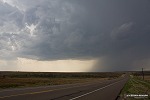
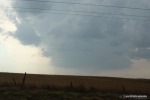
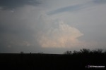
I stopped for a quick truck stop shower in Tulsa, and was on the Turner Turnpike by 10:30AM. Earlier, I did my morning forecast in Joplin, opting to target the triple point near the OK/TX border. I was ahead of schedule by a couple hours, so not in any hurry. After lunch in Yukon, I was on final approach to my target by late afternoon. I was watching the dryline/frontal intersection clearly visible on the Amarillo radar. The front sagged southward, but stalled at I-40 and started lifting back north. The dryline was between Shamrock and Amarillo, so I opted for Shamrock as the official 'target'. The first storm of the day went up at the triple point just west of Shamrock, so I jumped on it - intercepting near the town of Wheeler. A shot of the roads south of Wheeler:
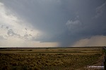
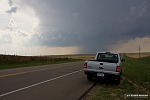
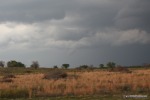
The storm was high-based, which is to be expected of a brand-new cell early in the day:
I'm having a problem with my GPS mapping software deleting old GPS points, so my locations/times from this point on are estimates. I followed the storm for the next hour or so, with not much happening. The storm seemed to be having trouble tapping moisture to the southeast. Somewhere near Reydon, OK the storm finally lowered its base and produced a decent wall cloud. Road options in this area are not great, with a river crossing to contend with. Since the roads were dry, I took a dirt road about a mile east of the highway to watch the storm. After a few minutes, I turned around and started heading back to the highway. Immediately I felt my right wheels sinking, with the truck pulling slowly to the right toward the ditch, leaning hard to the right side. Even though the road was dry, the dirt at the edges had the consistency of sand, about 4 inches deep - and when I turned around, I was just far enough to the side for my wheels to sink into it. I stopped immediately and got out, knowing that trying to drive out would get me into further trouble. The Lord provides, and this time in the form of an abundance of large, flat rocks, about 12 inches across, along the side of the road. I dug trenches (with my hands) in the soft dirt in front of the wheels, down to the harder dirt base, to give the front and back wheels a clear pathway back to the center of the road. I then placed about 10 of the big rocks in the rear wheel's trench, and got back in. I punched the gas and made it out! That was too close for comfort. I guess now I'll have to avoid the dirt roads even when they are dry.
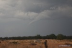
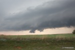
When I turned north on the highway toward the storm, the wall cloud lowered and tightened, spinning rapidly. I stopped just as it crossed the road and set up the cameras.
 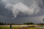 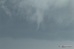
VIDEO CLIP: Rotating wall cloud and funnel near Reydon, OK (6x speed)
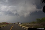
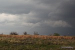
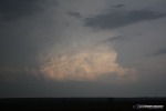
About this time, a new LP-ish storm to the west was visible:
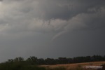
I kept up with my storm for some time later, at one point ending up right below a developing (yet still high based) RFD clear slot over Roll, OK. After this cycle appeared to be weakening, I dropped south to an east road option to get ahead of the storm again. The Canadian River crossing at this point was becoming problematic. I had to go fairly far south to get to the east option. While heading east, I looked north to see a well-developed funnel descending from the base. The funnel stretched and finally dissipated after about a minute. It was very high up, and I don't think there was a circulation on the surface.
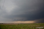
I continued east for a couple of miles, well ahead of the storm, and stopped on a hill to watch its progress. Supercell structure was evident.
At this time, new storms were visible firing to the south near I-40:
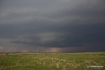
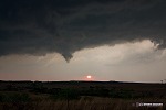
I witnessed one more brief funnel attempt on this storm, but was generally unimpressed by its continued failure to produce. My last view of the storm before I gave up on it near Leedey, OK was a long shelf cloud with the setting sun peeking through the rain curtains:
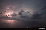
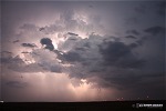
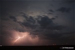
With the storm riding up the Canadian River, road options were terrible to keep up. Night was falling, and up to that point, the storm had failed to do much. So, I decided to call of the chase and head south to Elk City to get a hotel room before the town was overrun by storm chasers. The lightning on new storms to the south, west and east was pretty impressive, but rain and strong winds kept me from setting up outside. I made a few attempts nonetheless without much success, missing the best of the action. I discovered at this point that I didn't have my DSLR's cable release, so I had to do fixed-time exposures (couldn't really use bulb mode without the release). I did grab a few shots of a cell just north of Elk City, with lightning illuminating the cumulonimbus tower.
As it turned out, many storm chasers chose to stick with the storm despite the bad road network/nightfall problems. So I had no trouble getting a room in Elk City. The storm did go on to produce a tornado a couple of hours later, but I was happy to be in my room to rest up for the next day's event.
NEXT EVENT: Supercells in southern OK, OKC lightning show >
Storm Chasing Home | Tornado Intercepts | Storm Chasing FAQ | Expeditions by Year | Video Clips | Photo Gallery
GO: Home | Storm Chase Logs | Photography | Extreme Weather Library | Stock Footage | Blog
Featured Weather Library Article:
|