|
Home | Blog Index | Blog Archives | Christianity & Faith Essays | Storm Chasing Essays
Storm chasing forecast update 9, for April 26
This update is a couple of days later that I intended thanks to a full workweek, my apologies! The southern Great Plains/Texas panhandle region has seen a couple of good chase days this week - but good only in hindsight. All chase days aren't guaranteed tornado/structure bonanzas like that, true, but these were overperformers that I originally did not feel were worth expending a big chunk of my finite PTO and travel funds on. I'm not a "chase everything" chaser: I can't afford to be, in both time and money. And that's OK, most chasers aren't and have to be judicious and somewhat picky especially before the climatologically-favored peak in May and early June arrives. Sometimes that results in missing events like we saw this week, and I'm OK with that. So, let's look ahead and see what we have on the table in the coming period.
A trough has been sitting in the west, providing enough flow and inducing enough moisture return for the good chase days in the Texas panhandle. This trough will "eject" - meaning fully move east out over the Plains and Midwest - starting on Sunday. This will set the stage for a three-day period of good severe storm and tornado potential as this trough's strong upper level winds overspread good moisture at the surface.
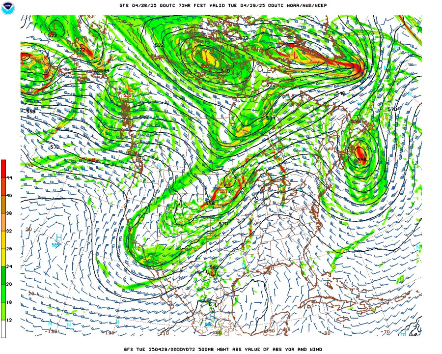
GFS 500mb forecast for Monday, April 28
Sunday's event looks the most conditional, thanks to a very strong cap (a layer of warm air just above the surface moist layer) that a lot of models have been consistent in completely preventing storms from forming along the dryline from Oklahoma into Nebraska. As models show now, the cap is too strong for any hope of storms forming and/or storms that do form surviving very long. If a storm defies that, however, it will be very good. It's a "boom or bust" setup that is a roll of the dice at this point. The plus is that it is setting up in prime chasing terrain in the High Plains of western Kansas and Nebraska, and it would be the first in a series of consecutive daily chase opportunities. The next day, Monday, is shown as another dryline event from Iowa southwest through central/eastern Kansas. Finally, Tuesday's event should be in the Midwest if not back home here in St. Louis as a cold front sinks southward.
As most chase setups do, all three of these days have some potential issues - mainly being the cap on Sunday and the positive-tilt orientation of the trough leading to boundary-parallel flow on Monday and Tuesday that could encourage early development into a squall line. That being said, logistically it isn't bad at all for a chase expedition: straight west on I-70 for Sunday, eastern Kansas into Missouri on Monday and back home Tuesday, requiring mileage/PTO cost on the low side for a 3-day Plains trip. I'm reasonably confident in this being enough for the first Great Plains chase trip of the season starting either tonight or Sunday night, depending on if confidence increases for sustained storms on Sunday in Kansas and Nebraska.
After this series of events, we'll be looking at another period of downtime that could last close to a week before another system might advance into the Plains.
The following table charts the probabilities for a Plains storm chase expedition taking place for the date ranges shown:
| 2025 Plains Chase Expeditions - Probabilities as of April 26 |
| April 27-29 | 85% | |
| April 30-May 3 | 10% | |
|
GO: Home | Storm Chase Logs | Photography | Extreme Weather Library | Stock Footage | Blog
Featured Weather Library Article:
|


