|
Home | Blog Index | Blog Archives | Christianity & Faith Essays | Storm Chasing Essays
Severe weather outbreak Tuesday
Update 5:37AM Monday: I was just awakened by lightning and thunder a few minutes ago from a weak storm passing over the house. Checking the radar, looks like some very active thunderstorms will be moving in at daybreak for some good photo ops. As for tomorrow's potential, the SPC has a moderate risk with very high severe probabilities from Mississippi to Kentucky. Could be a very interesting next couple of days.
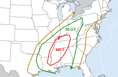
SPC severe storm risk for Tuesday
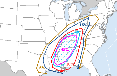
SPC tornado/wind/hail risk for Tuesday
6:51AM Sunday: Tuesday seems to be the weekday for this winter's severe weather events. We may be looking at a repeat performance of the January 29 wind event on this upcoming Tuesday, and possibly something much more significant. Models indicate that just like this last event, wind speeds look strong at all levels throughout the day Tuesday. The difference this time around is that the temperatures and dewpoints may be much higher, resulting in more instability (fuel) for strong storms. Temps in Charleston are expected to top 70F by midday!
Event potential looks fairly good with this system, but the nailing down a specific target area is way too early to call now. But, based on the latest model runs, I currently like southern Indiana as a combination of daylight storms, better terrain, just to the east of the low pressure track, decent deep-layer shear (turning with height), slightly backed surface winds and an easy drive from here in Charleston. Cloud cover (or the lack thereof), as with most winter severe weather events, will play a large role in tipping the scales on this being either another January 29 or a major tornado outbreak.
|


