
|
||||||||||||||||||||||||||||||||||||||
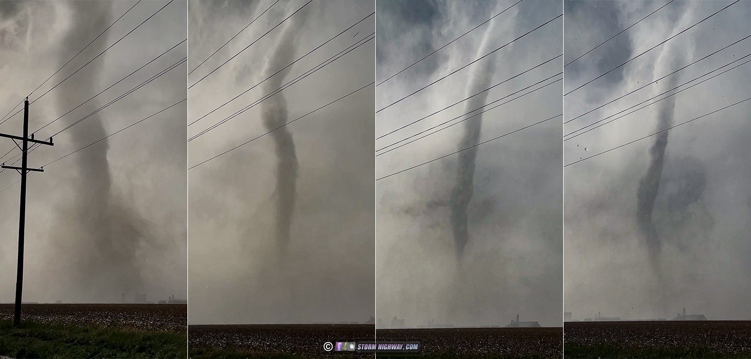
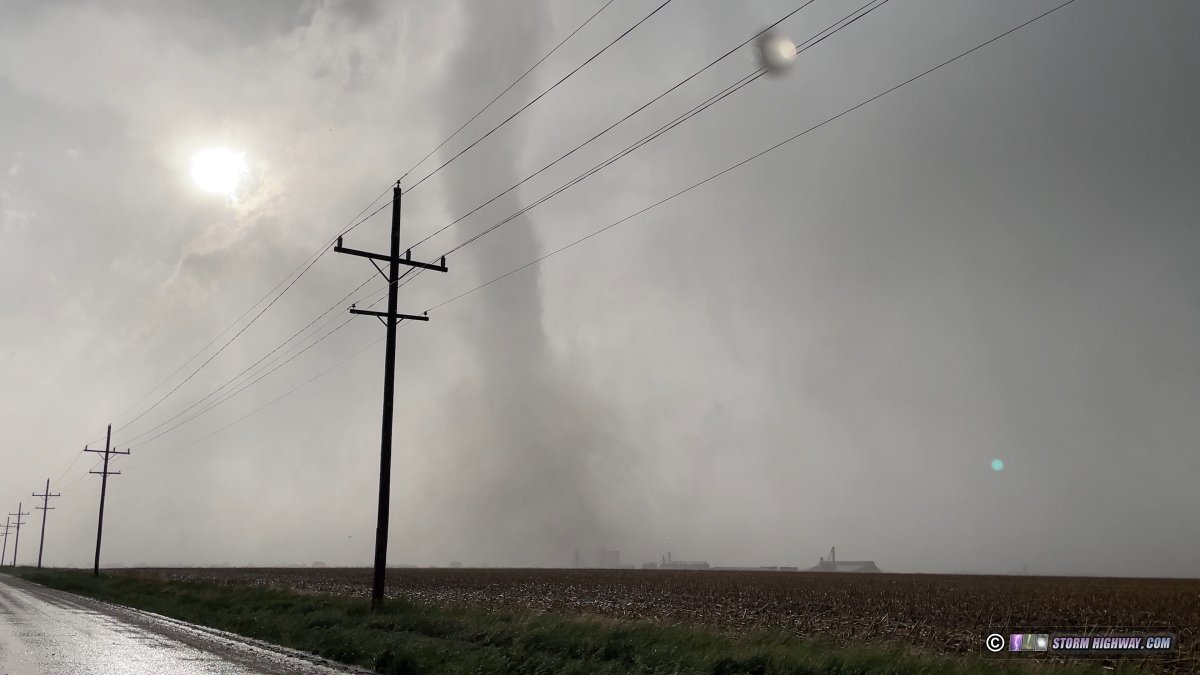
4K CHASE VIDEO: Tornado passes over Grinnell, Kansas GRINNELL, KS - I observed a strong tornado directly impacting the town of Grinnell, Kansas. The following is a log of the day's chase. I started the day in Junction City. Two main target areas were evident at first data check: the dryline bulge from Dodge City to Woodward, and the surface low vorticity region in northwest Kansas/southwest Nebraska. I liked the northern target better, as it was more of a secondary target (though still good) and I liked the idea of having storms more to myself (as most chasers were targeting the dryline bulge). The problem this day was that persistent low clouds, outflow and stable air were hanging out in all of these target areas through the morning. I decided to hedge between these two areas and position in Kinsley, Kansas to start out. Before I could begin this chase, I had a vehicle issue to take care of. I had realized right after leaving St. Louis the previous day that I was going to need an oil change soon, but I left too late to make it to any of the shops at home. So, my first order of business this day was to get the oil change done, hopefully in Junction City or Salina. But as it turned out, all of the quick oil change places in Junction City, Salina and McPherson were closed on Sundays. I stopped at the Salina Wal-Mart, but they were very busy and weren't going to be able to get to it for at least 2 hours. My only option was to drive the additional hour down to Wichita where there were several national-chain quick lube places open. I had enough time for this route diversion to not be a big concern. After the oil change, I headed back up to Newton and then west to Kinsley. Upon arriving there, I was still not out of the low clouds and cooler temperatures. I became concerned that the warm sector for storms to thrive would be too narrow here and to the south, which made the in-full-sunlight northern target area much more attractive. I made my final call for the northern target, making it to Kanorado (the Kansas/Colorado border town on I-70) right after storms began forming south of the interstate. The storms were high based and were not doing much with low-level organization. I also could not see any sign of an RFD developing anywhere among several of the updrafts. I stopped to do a data check at Goodland, initially intending to continue following the storms north into Nebraska. But then I saw the tornado warning go out for a storm near Scott City, about 50 miles to my southeast. This supercell, and others near it, all had strong-looking couplets on radar from their start, unlike the ones I was on up here. I quickly made the call to abandon the Goodland storms and intercept the better ones to the south. Right away, I realized I had a road problem for this maneuver. There were only north-south paved roads available at Goodland, Oakley and Grainfield. Between these was the unpaved rural road grid, but the forward flank cores of the supercells had been raining on them for almost an hour now. I considered those unpaved roads complete no-gos. Even the ones with gravel aggregate are treacherous when wet, and the gravel often ends suddenly at unpredictable spots the farther you go. The pure mud is a expensive chase-ender if you end up on it, no matter how big of a 4x4 behemoth you have! These mud roads are like driving on the slickest black ice from freezing rain. Not only can you get stuck on them right on their centerlines as your wheels gradually sink deeper, the bigger risk is losing control and sliding into the water-filled bar ditches. When that happens, you will need a farm tractor to get out - even professional tow companies won't even try. You also risk flooding your car if the water in the ditches is deep enough. And in this case, I'd be dealing with all of that in the vicinity of violent wedge tornadoes. It all adds up to a completely unacceptable risk to even attempt it. My point being, these unpaved roads are just out of the question for me when they are wet. Sure, some chasers risk it and do OK (sometimes) - but I just won't. Out of my paved options south from I-70, only one was viable for intercept. The storms were already east of Highway 37 out of Goodland. The mesos/tornadoes were already right on Highway 83 south of Oakley, and I would not make it there before they crossed that road and moved east of there onto the unpaved grid. That left Highway 23 south of Grainfield as the only one. But by the time I reached Grainfield, I was back in the stable low-level air with thick fog and stratus completely obscuring any view of the storms to the east. This did not improve as I headed south on Highway to Gove City. I figured that the storms would dissipate rapidly after encountering the stable air, and was resigned to a bust. But as the lead storm south of Grinnell continued north, the couplets on radar weren't showing any sign of slowing down. I decided it would be worth heading back to Grinnell to see if maybe the RFD would carve out a gap in the low clouds and fog so I could see something. I sat at the Grinnell I-70 interchange waiting for the storm. Eventually, I could see what looked like a forward flank shelf cloud emerging from the fog to my west, feeding south into the mesocyclone with bright skies behind it. To the southwest, a darker area emerged where the tornado should be, and radar showed it was still there and still quite strong. I was shocked to see how the stable air apparently was not hindering this storm at all. At this point I was getting an uneasy feeling. The couplet was only a couple miles south of me and moving north-northeast, which I initially judged to be heading east of Grinnell. I as of yet had no visual on the tornado. Should I go west or east to get out of its way? I initially chose to go west out of Grinnell on the first available road north of I-70 (I did not want to use the interstate as there is no safe place to stop or turn around if needed). But upon reaching the southwest corner of the town, east-southeasterly winds began ramping up continuously to alarming levels, and I looked south to finally see the tornado emerging out of the fog, coming right at me. I turned the car around, pausing for a moment to watch the tornado as I faced it, confirming its motion as my next move was of critical importance. East! East! As I made the move eastward, winds turned southerly as the tornado passed less than a half mile behind me. I kept going until I was out of that stronger wind field, at which point I watched it go through Grinnell as a tall, narrow stovepipe with an audible roar:
|
||||||||||||||||||||||||||||||||||||||


 ABOVE: Tornado moving through Grinnell, Kansas


Web Site Design and Internet Marketing by CIS Internet