|
Home | Blog Index | Blog Archives | Christianity & Faith Essays | Storm Chasing Essays
Great Plains 2025 Storm Chasing Expedition Logs
Season Epilogue: It feels a little strange publishing my end-of-season Plains recap on the same day as one of the better tornadoes of the decade in western Nebraska, but that's storm chasing for you. The upper-level pattern has not quite shifted completely into the summer "death ridge" yet, but the nebulous and subtle nature of the flow over the Plains has not been something I will typically make a mutiple-day trip for. These types of patterns can and do produce, sometimes big (as we saw today) but you just can't count on that with 99 percent of them. Models don't show much changing through the end of the month, so I feel confident that my Great Plains spring season for 2025 is finished.
So, how was it? Despite logging 8 "stat-padder" tornadoes for the season, it was a below-average spring for me. Season quality is subjective from chaser to chaser - it all depends on if the days you chose to go out produce spectacularly, and even if they do, you still have to make all of the right decisions on those good days. That means one chaser can be having the season of their lives, while others are struggling. The big and defining miss was the May 16 tornado in St. Louis, but after forensically recapping that day, I just don't see a scenario where I could have reasonably seen that coming in time. I did not come away with this season with a "wall hanger" tornado - but then again, I don't most years. The inverse of this was last year, when I added three all-time best tornado intercepts to my logs in a personal record-breaking season, one that not all chasers came away with great results in. I see my 2025 as simply the law of averages playing itself out, especially right after a bonanza year like 2024.
I try to make it a practice to focus on the things to be thankful for despite the misses. My season was free of major incidents or problems, and I *did* see a lot of tornadoes. I didn't have to use up a lot of PTO to make my trips. My gear all performed like it's supposed to. I'm looking forward to what the summer storm season in the Midwest has in store!
2025 Spring Plains Season Totals:
- Plains expedition trips: 2
- Plains days on the road: 5
- Plains chase days: 4
- Plains tornadoes: 3
- Midwest tornadoes: 5
- States covered: 4 (Nebraska, Kansas, Missouri Illinois)
2025 Great Plains Chase Day List
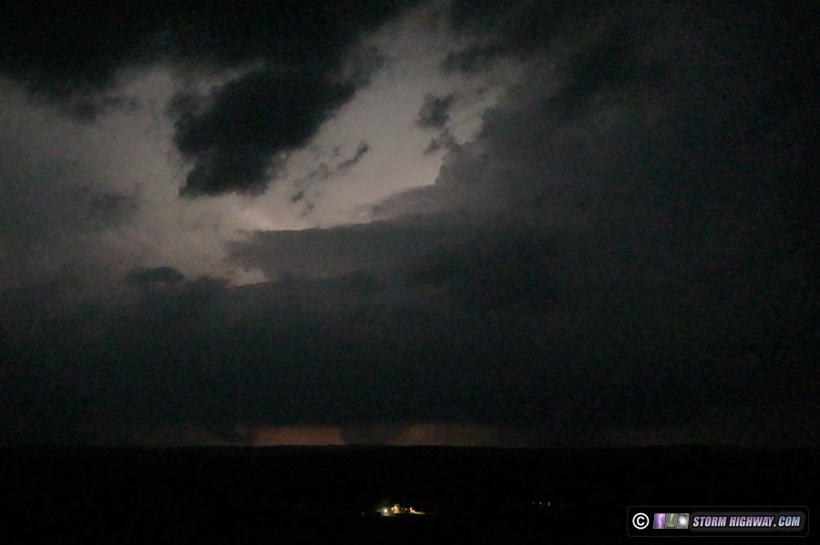
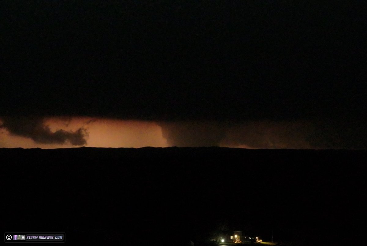
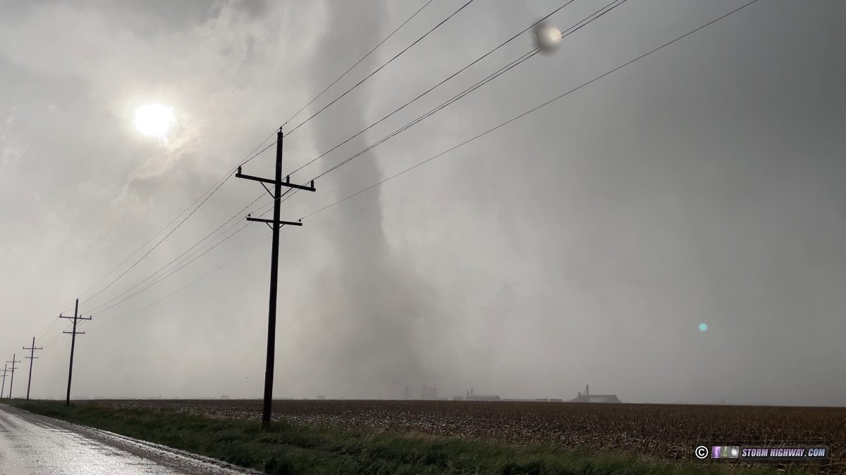
 Day 1: April 27: Cherry County, Nebraska tornado (Trip #1 Start) Day 1: April 27: Cherry County, Nebraska tornado (Trip #1 Start)
I observed a nighttime wedge tornado north of Mullen in the Sandhills of Cherry County, Nebraska with one of the more remarkable and prolific tornadic supercells of the decade. This log has its own page here.
 Day 2: April 28: Abilene, Kansas supercells (Trip #1 End) Day 2: April 28: Abilene, Kansas supercells (Trip #1 End)
I awoke early in Brady to do a data check. There were three possible dryline targets I had anticipated as the upper-level jet moved out into the Plains, and wanted to start early enough that I could get to any of them if needed.
The first was the moderate risk area in northern/central Iowa that had the most volatile parameters, then two other areas that would see slightly less-but-still-good shear/instability overlaps: one in northeastern Kansas and another down in southwest Oklahoma and the Texas panhandle. The Kansas one was the most appealing - it barely wasn't a secondary target, with volatile parameters increasing through the evening and models all agreeing on supercells there. Kansas would mean I'd only be 4 hours from home at the end of the chase. Texas had similar potential as Kansas, certainly nothing that would warrant the long haul to get there and the extra day on the road to get home. Iowa looked decent enough, but models were waffling on storm coverage and squall line evolution for storms there - plus, the entire state was clouded over and would not clear out until afternoon. Iowa would also mean another overnight stop necessary before getting home. I decided the Kansas option was more than good enough, and it was a short drive that allowed me to go back to bed for a few more hours.
I was back on the road at 11am, opting to drop south at Lincoln and stop to watch things evolve at Clay Center, Kansas. Eventually, a storm rapidly fired down at Salina with other updrafts starting to get established near me as well. The I-70 storm was the healthiest of all of them, and models had agreed on this area seeing the better parameters into the evening. So, I made the short jump to this storm at Abilene.
As I approached the storm, it had already began lining out with additional strong convection firing on its western flank. The original updraft fought to maintain itself, but it was a losing battle as the outflow was just too much. I awaited the tail-end cell to the southwest that appeared to be organizing and avoiding the squall line transition. This storm did manage to develop a good RFD surge that cut into the updraft:
But it was all for naught, as outflow from the lead storm had already undercut the second storm's updraft. Radar showed this outflow pushing south ahead of both storms updrafts, spelling a long-term cessation of the tornado potential. I decided to stay on I-70 just ahead of these storms in case the updrafts managed to catch up to the outflow and re-establish surface inflow, but this never happened. The storms were also moving much faster than I'd anticipated. I wasn't gaining much ground on the lead storm despite 75mph speeds on I-70. The storm developed strong flanking line convection on its RFD, which made for a dramatic sight even from a distance on I-70 near Topeka:
Meanwhile, a portion of the trailing end of the squall line to the west was getting established. It was south of the pesky outflow, but it would require an hour-long backtrack to intercept and it was already linear, with no apparent look to defy that. After one supercell RFD cycle in that line failed to persist, I decided I was done with it. The last potential option was to try and get in front of the lead storm on I-35 northeast of Kansas City, but with its current speed, its failure to wrap up any strong, persistent circulation and its diminishing radar structure, I decided that wasn't going to be worth it. I called the chase, continued east and made it home just after midnight.
 Day 3: May 17: Western Missouri/eastern Kansas thunderstorms (Trip #2 Start) Day 3: May 17: Western Missouri/eastern Kansas thunderstorms (Trip #2 Start)
I departed St. Louis during the late afternoon on Saturday and drove to my overnight stopover at Junction City, Kansas to begin the second Great Plains chase trip of the season. On the way, thunderstorms persisted for several hours in western Missouri and eastern Kansas, with the lightning visible from I-70. Models suggested that this would not get much closer to my travel route, but some new cells developed right along the interstate near Concordia, MO and produced a couple of nice clear-air bolts. I turned on the high speed camera and prepared to stop and shoot for a while, but the storm didn't produce any further bolts. Between Kansas City and Topeka, some nice bolts were visible with storms about 20 miles to the south, but the terrain and lack of easy pull-offs made it not worth stopping and postponing my late-hour arrival in Junction City. No photos or video captured.
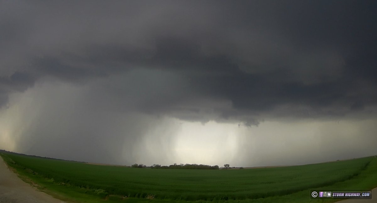
Day 4: May 18: Grinnell, Kansas tornado
I observed a strong tornado directly impacting the town of Grinnell, Kansas. This event has its own page here.
Day 5: May 19: Du Bois, Nebraska tornado (Trip #2 End)
I started the day at 10am in Junction City. I didn't do much of a proper forecast today beyond looking at satellite and mesoanalysis. Three dryline targets seemed apparent to me during my first data check: a dryline bulge down near the Red River, another along the Kansas/Nebraska border and the moisture tongue curving back into the vorticity-rich surface low in central Nebraska. The CAMs (convective-allowing models like the HRRR and RRFS) showed wildly varying depictions on how the day would evolve with each new run, so I did not put much stock in what they were saying. The only insight they gave was that the day looked potentially messy with likely a lot of storms going up everywhere. On most days in the Plains, dryline bulges, triple points and dryline/outflow boundary intersections are usually the beacons for chasers on where to go, regardless of what models say. Models can easily lead chasers astray from those fundamentals.
Storms had already fired at the early hour down in southern Oklahoma, so I feared the cap was too weak there. That left the KS/NE border dryline bulge and the surface low. I chose the former, as satellite showed an encouraging picture of a broad zone of clearing between the dryline and cloud cover/precip to the east in Missouri. I headed up to Marysville, Kansas as my initial target.
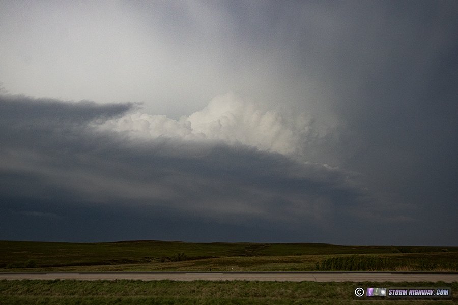
I sat and waited near Marysville for about 90 minutes before storms began forming on the dryline immediately to my west and southwest:
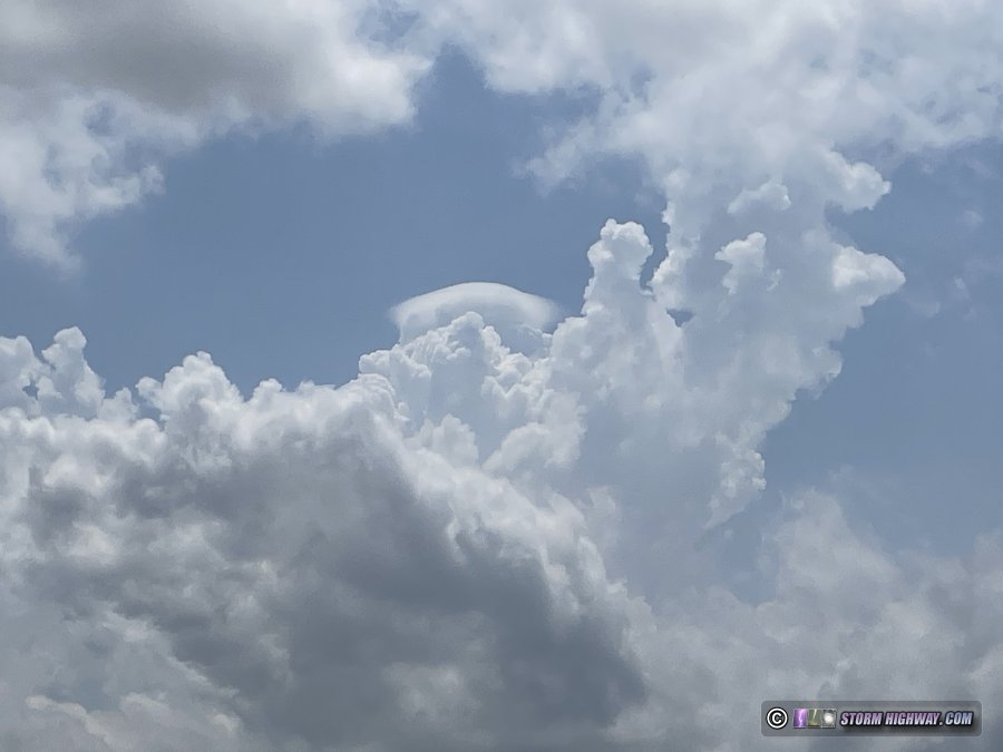
Pileus cap on developing convection
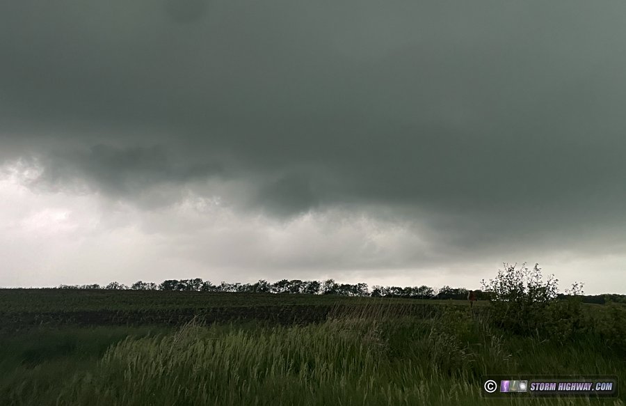
As I waited for a dominant updraft, things were not taking off as fast as expected. It took a long time for a coherent storm to emerge, and even then, it did not last long. Several other updrafts fizzled out as they passed by me. Finally, a storm just to my south looked like it was finally getting itself together. I dropped south of Home, Kansas for about 5 miles to watch this approach. It was producing a nice RFD, but inflow at the surface seemed weak. Finally, a wall cloud with a better look began organizing near Beattie, KS as I moved north and east to stay with the storm. Cloud tags on the south end of the wall cloud were spinning rapidly, and this motion indicated a tornado could be minutes away.
Unfortunately, I had a road problem at this point. I initially took Deer Trail Road eastward toward St. Bridget, but 2 miles in, the road dead-ended into a three-way intersection with pure dirt roads going north, east and south. With the RFD precip right behind me, those roads were absolute no-gos: they would all be impassable mud within minutes of the rain arriving. I turned around and headed back to the paved main road as the RFD precip passed overhead. I waited for the VIL core (hail) to cross to my north, then headed north across the state line at Summerfield, then east again through Pawnee City hoping to beat the hail before it overtook that road. The storm had slowed some and turned right more, allowing me to make this move without incident. I finally was back in position in the inflow notch of the storm at Du Bois.
Here, the storm was fighting outflow, but surface inflow was countering and making it into several areas along the north side of the RFD gust front, each spinning rapidly. Finally one of those became dominant, and managed to wrap up and produce a weak tornado consisting of a debris cloud under a funnel about a mile northeast of Du Bois:
The outflow was too overpowering for this to last long. A second RFD surge wrapped in about 3 miles to the east of this area, with a visible clear slot:
There may have been something going on back in there, but the precip rapidly filled in and prevented any good view. Radar data did not indicate that anything was likely happening there at that point.
After this, the storm began a long, slow downturn in intensity. In the distant east, a harbinger of the storms' doom loomed: a long arcus cloud marking the edge of outflow from earlier storms in Missouri. This meant the storms here and to the south (in the form of a squall line heading for the St. Joseph and Kansas City areas) would soon hit that stable air and fizzle. That was enough for me to call the chase and begin heading home.
That non-chase mode did not last long! I had initially wanted to beat the heavy rain in the line to I-70 in order to have a mostly downpour-free drive east to St. Louis. But as soon as I passed Platte City, tornado warnings lit up on two very strong-looking couplets on the now-bowing squall line to my north. These were both too close to I-29 for me to make it back up there in time. I considered an intercept on I-35 north, but I felt that there would be no way these would last that far into the stable air. I was right about that (for a change).
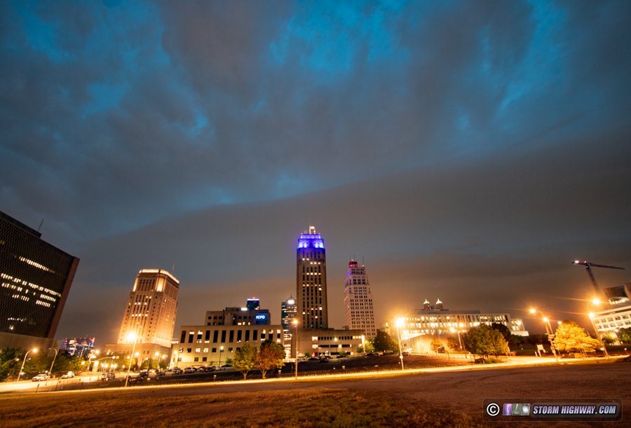
Continuing south toward I-70, a structured shelf cloud became visible on the line's outflow heading into Kansas City. Shooting this would only divert me a few hundred feet off of my route, so I stopped on the east side of downtown. The shelf was not very dramatic as it arrived overhead, at least not as good as it had looked from a distance. As a note: this is a bad spot to shoot downtown KC, as the ground slopes upward from left to right and makes it look like the horizon isn't level. I didn't have time to find something better.
My next play was to get to towers in the Columbia, MO area to shoot lightning in stratiform precip that radar showed was moving that way. But it was about this time that I noticed the tornado warnings starting to go off in the St. Louis area. Though missing the May 16 St. Louis tornado had forced me to essentially give up my home target bias (since it had failed so spectacularly and cost me many good events elsewhere over the last 15 years), I was still filled with anxiety watching this evening's events unfold back home from 3 and a half hours away. It appeared there was a boundary (either the warm front or an old outflow) south of the metro area that caused every storm that crossed it to spin up a strong circulation. The first one that happened during the daylight hours was highly visible and photogenic, as Twitter reports showed. To the southwest of all of this, numerous mesovortices along the main squall line were also potentially producing tornadoes. As all of this continued, it looked as if St. Louis might be getting its own "night of the twisters" if whatever boundary was causing this managed to lift into the city. And there was no way I'd make it in time.
I pressed on eastbound, but with resignation. I would miss all of the supercellular tornadoes ahead of the line, but it looked like I had a shot of beating the squall line into downtown. Resignation slowly turned to relief as radar showed surrounding convection enveloping the supercells and disrupting them. It also appeared the tornadogenic boundary was not moving north with the rest of the system, as further spinups were not occurring any closer to the metro area. As I got to within an hour away, the lead supercells had been completely absorbed by competing convection, ending that threat. I managed to beat the squall line into downtown by minutes, but it had also weakened considerably and no longer had any circulations on its leading edge. I was not even seeing much lightning as I drove through the metro area.
I made it home ahead of the line, again with minutes to spare. I had just enough time to unpack the car before it arrived in a virtually completely-weakened state. This chase - lasting right up until my arrival home - brought Plains chase trip #2 for the year to a close.
GO: Home | Storm Chase Logs | Photography | Extreme Weather Library | Stock Footage | Blog
Featured Weather Library Article:
|


