|
Home | Blog Index | Blog Archives | Christianity & Faith Essays | Storm Chasing Essays
Storm chasing forecast update 10, for May 9
As models begin entering the peak season time of late May, anticipation ramps up into what period usually produces the best storm chasing events in the Great Plains. As is typical for early May in most seasons, we are seeing a lull in the action as the relative southward position of the jet has kept moisture and severe weather confined mostly south of Interstate 20 in deep south Texas and even northern Mexico. Unfortunately, this general pattern looks to continue, with most upper-level waves traversing the southern half of the country. These repeated waves to our south will prevent moisture from making it much farther north than the Interstate 40 latitudes.
The biggest event shown in the coming week is a potent shortwave trough overspreading strong southwesterly flow aloft over the Great Plains starting on Wednesday the 14th:
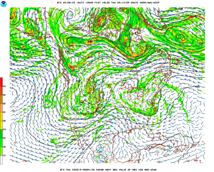
GFS 500mb forecast for Wednesday evening, May 14
The problem now is 700mb temperatures are shown in the 12 to 13°C range, which translates to a very strong cap above the surface moisture layer that models show preventing storms from forming this day. It's similar to the late April event this year where if storms do manage to form, they will be good. But this time, the cap is portrayed as stronger and much more formidable obstacle to overcome. As such, I'm much less optimistic about this prompting the second Plains trip of the year.
This same trough will bring supercell and tornado chances to the Midwest as it moves overhead on Thursday and Friday as the jet remains overtop of good moisture at the surface. The 700mb temperatures are cooler over the Midwest on those days, and there are better signals for storms forming where the best shear/instability overlaps are.
Beyond that, things don't look all that great as we move into the last half of May. Models indicate a risk for passing troughs to stagnate in the eastern US, blocking future western troughs from making it far east enough for reliable Plains supercell/tornado setups. That being said, we should have upper level flow/low level mositure overlaps *somewhere* in the Plains and Midwest on many if not most of those days. It's just that none of them are standing out as potential trip-worthy sequences right now for the type of chaser like me who can't chase everything all season. The Plains potential during that period certainly change as we get closer in time, so as always, we'll just wait and see.
The following table charts the probabilities for a Plains storm chase expedition taking place for the date ranges shown:
| 2025 Plains Chase Expeditions - Probabilities as of May 9 |
| May 10-14 | 30% | |
| May 15-19 | 15% | |
|
GO: Home | Storm Chase Logs | Photography | Extreme Weather Library | Stock Footage | Blog
Featured Weather Library Article:
|


