|
Home | Blog Index | Blog Archives | Christianity & Faith Essays | Storm Chasing Essays
Connecting safe cycling routes in the St. Louis metro east: Scott AFB, O'Fallon, Shiloh and Mascoutah, Illinois
UPDATE (July 2026): The bike/pedestrian trail across Silver Creek to MidAmerica Airport is now OPEN! Click for details.
The St. Louis metro area has one of the best network of bike trails in the Midwest. This is particularly true of the Illinois side of the metro area (the STL "Metro-East") with the expansive and growing Madison County Transit and MetroBikeLink trail systems [10].
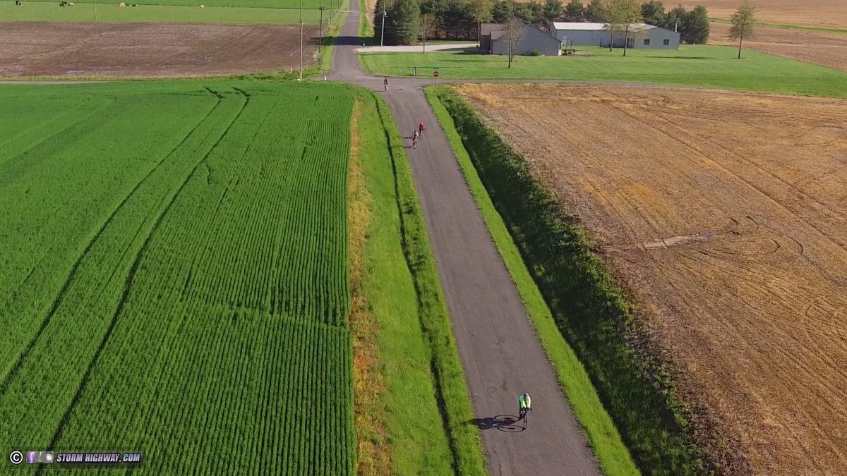
I have been a regular cyclist on the county roads mainly east of Illinois Highway 4 in eastern St. Clair and western Clinton Counties. These lesser-traveled, straight, flat and open paved roads (Fig. 1) offer a web of relatively safe cycling route options around the rural eastern fringes of the St. Louis metro in between Mascoutah, Summerfield, Highland, New Baden, Trenton and beyond.
With knowledge of the local road network and cycling experience on many of them, I created this map of the region (map updated for July 2026). The main points of this map are to show the current "gaps" in cycling-safe routes around the region along with the existing and officially-planned dedicated trails. Roads shaded in red are ones that I do not consider to be safe options for cycling due to combinations of high speed, heavy traffic and/or prohibited access. The roads shown in black are relatively safe to use as part of a cycling route due to low speed limits and/or sparser traffic. Click on the map to view the full-size version in a new tab. |

Please Note:
- The trails shown in purple on this map are purely conceptual and have NOT been officially proposed or surveyed.
- Not all streets and roads are shown. Most of the unmapped residential streets in the towns and cities shown can be assumed to be "cyclist friendly" (shaded black on the map).
Trail descriptions (Updated July 2026)
- Air Mobility Drive Trail: A completed trail along Highway 158 (Scott-Troy Road) connecting the Seibert Road Trail with the mainline MetroBikeLink trail.
- Apple Street Trail: A short trail under construction from O'Fallon Community Park to East 1st Street in O'Fallon, on schedule to be completed this year.
- Berm Trail: A completed paved trail running east-west across nearly the full width of the town of Mascoutah between Lake Road and North Jefferson Street (State Route 4).
- Brandywine Trail: An under-construction trail extending east along I-64 from South Lincoln Avenue in O'Fallon, expected to be open in 2027. The planned Main Street Trail will connect the Brandywine Trail with North Main Street.
- College Road Trail: An officially-proposed trail and bridge across Silver Creek connecting the west end of College Road in Lebanon to Reider Road.
- CSX Railroad: In 2015, CSX took their "Illinois Subdivision", their designation for the St. Louis to Vincennes, Indiana line, out of service due to the lack of on-line shipping customers and through traffic. This included the deactivation of all grade crossing signals, removing sidings, spurs and switches and physically cutting the rails at either end of the out-of-service portion of track.
These events prompted speculation that the line could be formally abandoned at some point in the future, and accordingly, state and local officials have expressed interest in using the line as a major rails-to-trails project across southern Illinois if that occurs. However, CSX has gone on the record stating they have no intention of selling or abandoning the line, and there have been talks with short line rail operators taking over the line's operation, returning it to service and growing its on-line customer base.
Should the Illinois Subdivision ever be abandoned, the implications would be far-reaching and transformative for the trail network in St. Clair County as well as in southern Illinois. A continuous east-west trail across the state would be a major development, no doubt becoming a centerpiece of the trail network in O'Fallon, Lebanon, Trenton and beyond. Lebanon's long-sought-after connection to the west would be accomplished without the need for costly new bridges across Silver Creek, additional right-of-way acquisition and the complexities of a trail along Highway 50. O'Fallon and Lebanon would become destinations for cross-counrty riders.
While some rumors surfaced in late 2025 suggesting the line could be reactivated between Shattuc (just east of Carlyle) and Vincennes, no official news or any substantiating information from CSX has been publicly announced. Even if that were true, it's unlikely that the west end of the line would be affected by such a change. At this time, it appears unlikely that CSX will relinquish the line. Notwithstanding, this situation is one that cyclists and trail advocates in our region should be keeping an eye on.
- Highway 50 Trail: An officially-planned trail along Highway 50 from O'Fallon Community Park to at least Quarry Road or the future Trolley Trail [12]. Construction on the portion of the trail between O'Fallon Community Park and Scott-Troy Road (Highway 158) is expected to get underway soon, with an expected completion in 2027.
- Lebanon Connector: A conceptual trail along the yet-to-be-announced new segment of the Highway 50 bypass from Highway 4 to Rieder Road. A short section of this connector road has been built and signalled at Rieder Road, but no timeline for the connection to the eastern bypass segment in Lebanon has been announced.
- Lebanon Trail: A conceptual (not yet officially proposed) path beginning at MidAmerica Airport, paralleling Illinois Route 4 northward across Interstate 64 and on to Lebanon.
- L&N Railway Trail: An officially-planned trail along the old Louisville and Nashville railroad grade linking Mascoutah with the SWIC (Southwestern Illinois College) campus. The segment of the trail in the town of Mascoutah is currently under construction with a planned completion in 2027. No further plans for the rest of the trail have been made public. [12]
- Main Street Trail: An officially-planned trail along North Main Street in O'Fallon extending from Highway 50 to the Shiloh village limits just south of I-64. A branch of the trail will extend west to the Brandywine Trail.
- Mascoutah Trail: A conceptual (not yet officially proposed) continuation of the MetroBikeLink Trail from MidAmerica Airport to Mascoutah, following Illinois Route 4 on the east side of MidAmerica Airport.
- MidAmerica Trail* (now open!): The extension of the MetroBikeLink trail along the light rail tracks from the Shiloh/Scott station to MidAmerica Airport. Like most of the MetroBikeLink trail, the MidAmerica Trail* shares the right-of-way with the light rail tracks, including road, bike and rail bridges across Silver Creek. Silver Creek was the costliest obstacle to overcome in constructing a cycling path accessible to communities east of Scott AFB.
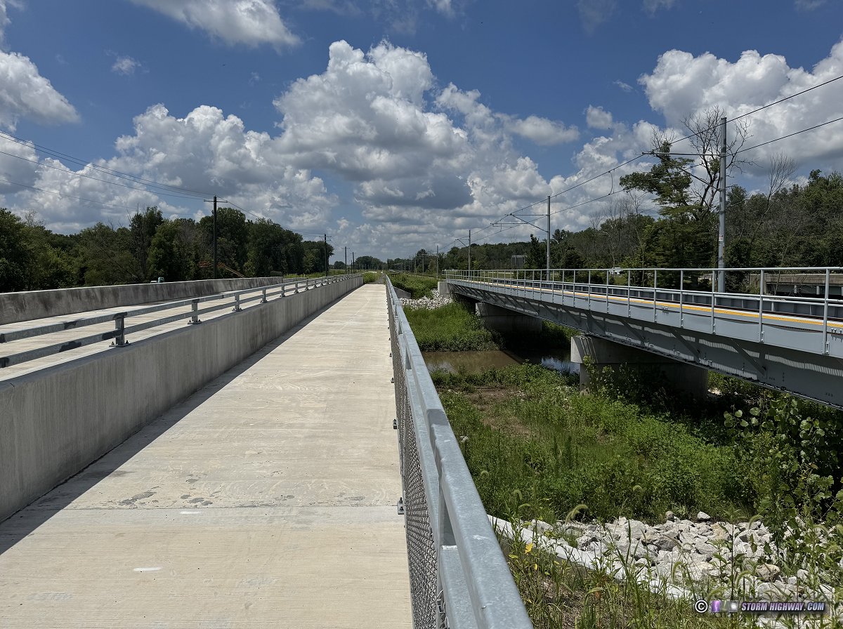 Silver Creek bridges on the new MetroBikeLink trail extension to MidAmerica airport Silver Creek bridges on the new MetroBikeLink trail extension to MidAmerica airport
- MetroBikeLink Connector: A conceptual (not yet officially proposed) path connecting the Route 161 Boardwalk and Trail with the MetroBikeLink trail. The connector would begin at the Route 161/Route 158 intersection and continue west along the south side of Scott AFB to Section Line Road. Cyclists would then use Section Line Road to reach the MetroBikeLink trail at Shiloh Station Road. The connector, along with the Route 161 Boardwalk and Trail, would give Mascoutah cyclists access to Belleville and its system of trails.
- MetroBikeLink Trail: A completed, paved, dedicated bike/pedestrian path built along the Metrolink light rail tracks from Belleville to MidAmerica Airport. The trail parallels the tracks for most of its length [7].
- North County Road Trail: A conceptual trail along North County Road in Mascoutah connecting the Route 161 Boardwalk and Trail with the residential street grid in Mascoutah.
- O'Fallon Connectors: Connecting the existing trail network to O'Fallon is a priority, but I-64 and Highway 158 are significant obstacles presenting high costs for a trail route to cross. These three options are conceptual routes:
- Option A would likely be the simplest, lowest-cost route to connect the core of O'Fallon's population to the Seibert Road trail and the rest of the network, with a single bridge across I-64 (or widening of the existing South Lincoln Avenue bridge). Current official plans for part of this route include a bike lane on South Lincoln Avenue to extend to Frank Scott Parkway. The Village of Shiloh has officially proposed trails between Main Street and Seibert Road that could also serve as the connection to the existing network.
- Option B would involve a single new bridge (or widening of the North Main Street bridge) to trail segments along the new Frank Scott Parkway Extension and Highway 158. Official trail plans for parts of this segment include the Main Street Trail and the trail along the new Frank Scott Parkway extension.
- Option C would be the costliest, but safest, of the three, with bridges across both Highway 158 and I-64 to use the rest of the abandoned Old Highway 158 to reach Seibert Road.
Options A and B would still require riders to navigate a risky at-grade crossing of Highway 158, so those would likely require a bridge across that highway at some point for the safest transit.
- Rieder Road trail: An officially-proposed bike and pedestrian path from Wherry Road and I-64 northward to US Highway 50, paralleling its namesake road [1].
- Route 161 Boardwalk and Trail: An officially-proposed bike and pedestrian path from Mascoutah to the southern gate of Scott AFB, paralleling its namesake highway and including a dedicated bridge across Silver Creek [1].
- Shiloh Station Road Trail: A completed trail connecting Englemann Park with the mainline MetroBikeLink trail.
- Siebert Road Trail: A paved trail running from Scott-Troy Road (Highway 158) along Siebert Road to South Main Street in Shiloh. Official plans are to extend the trail east across Route 158 to the Scott AFB gate.
- St. Vincennes Trail: An officially-proposed bike and pedestrian path built parallel to Old Vincennes Trail, a street on the east side of O'Fallon. [1].
- Trestle Trail (currently closed): A completed trail on the southeastern edge of the town of Lebanon, IL, named for the CSX railroad bridge it passes under. This short but important trail connects the dead-ends of East McAllister Street and Korte Sewald Road, providing the first cycling-safe link to the county road network south and east of Lebanon. The trail closed in 2026 pending acquisition of new insurance coverage. No date for its reopening has been made public.

Fig 7: Trestle Trail in Lebanon (currently closed), connecting the town with the cycling-safe county road grid to the south and east.
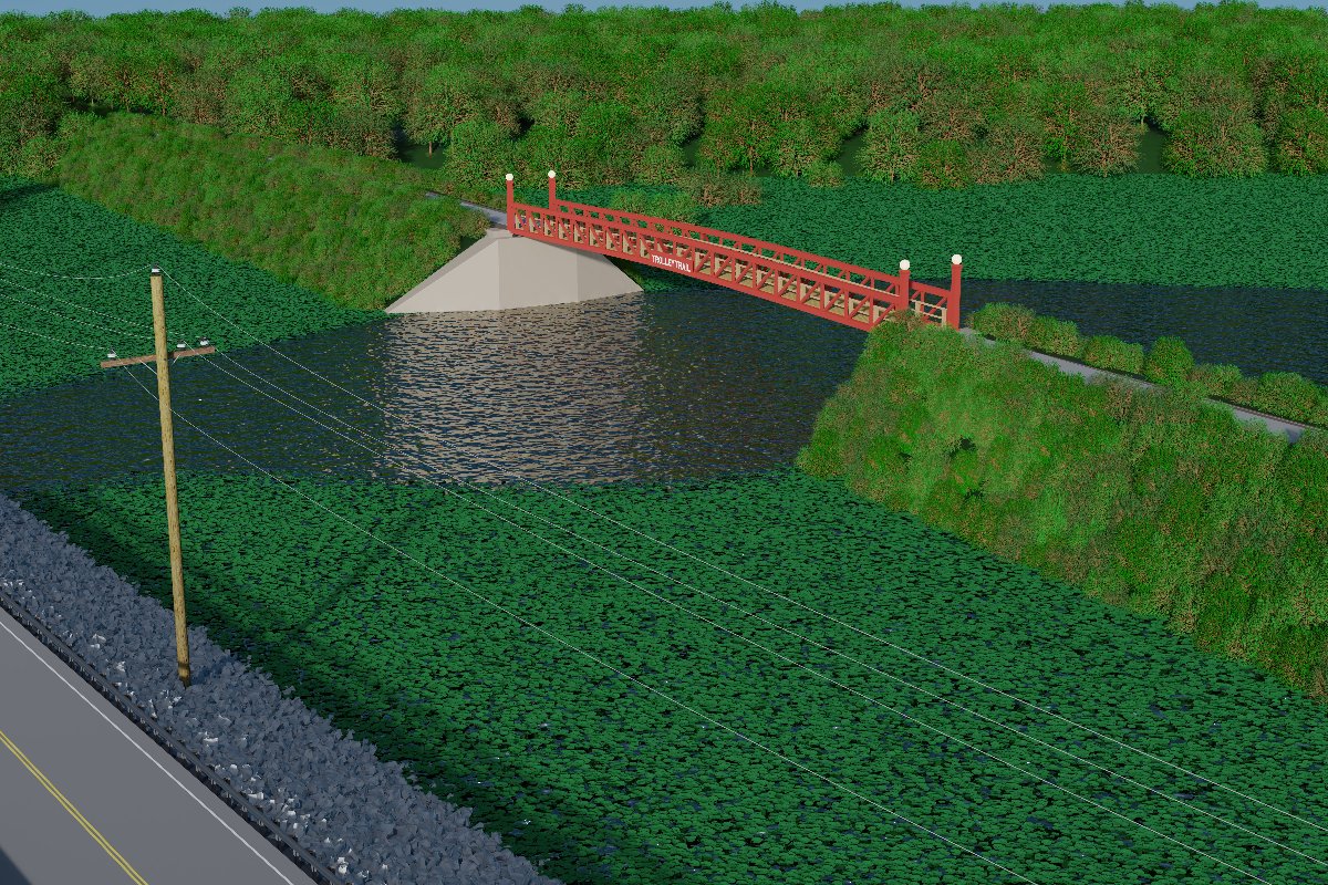
- Trolley Trail: An officially-planned bike and pedestrian path from Borchers Lane east of O'Fallon to Belleville Street in Lebanon, paralleling US Highway 50. Also referred to as the US 50 Bypass Trail on some maps, this path follows an old interurban trolley line. This trail would provide a safe cycling connection from Lebanon to O'Fallon via Borchers Lane and the proposed St. Vincennes trail. The conceptual Trolley Trail Connector would parallel Highway 50 to True Value Drive, a frontage road along Highway 50 and Highway 4 on the south side of Lebanon.
Several attempts have been made to begin the initial surveying and design work on the Trolley Trail, with a $900,000 grant secured from the state of Illinois in 2023. However, no local, county, city or regional government entities were willing to accept the funds and the adjacent liabilities and responsibilities of managing the project, so the grant was put on hold. As of July 2026, no plans for any further progress on this trail have been made public.
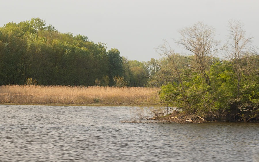
Fig 8: Silver Creek at the location of the planned Trolley Trail and bridge, west of Lebanon. The old interurban line roadbed embankment that the trail is based on is visible at right.
BELOW: Official 3D concept renderings of the Trolley Trail along Highway 50.
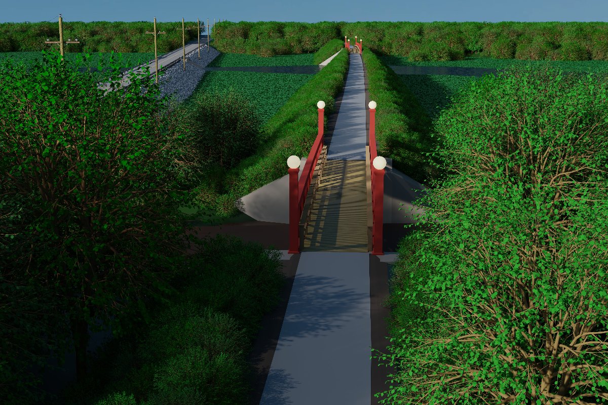
MidAmerica Trail* Highlights
This trail has been built and is now open!
- Right-of-way acquisition from private landowners is one of the biggest hurdles for trail development, and this was minimal for virtually the entire trail length to MidAmerica Airport. The segment from Shiloh/Scott station to MidAmerica Airport will be completely contained within the light rail right-of-way similar to the rest of the MetroBikeLink trail. The Mascoutah Trail around MidAmerica Airport is on land already owned by St. Clair County, eliminating right-of-way acquisition costs and complications.
- A bike path bridge built at the same time as the light rail bridge, possibly even using the same (slightly widened) approaches, abutments and piers, was a much less expensive way to cross Silver Creek than a dedicated trail bridge.
- The MidAmerica trail* alignment brings the MetroBikeLink/MidAmerica dedicated bike path route closer to O'Fallon. O'Fallon cyclists are now able to use the lightly-traveled Shiloh Valley Township Line Road to reach the I-64 crossing at Rieder Road.
Priority Trails
At minimum, trails connecting the residential street grids of O'Fallon, Lebanon and Mascoutah to the existing network are the essential pieces remaining to complete a safe commuting and long-distance cycling infrastructure for the local population.
With that goal in mind, priority trails for funding would be:
- Priority #1: O'Fallon Connection: Any one of the three O'Fallon Connector options shown on the map above would be the most impactful new trail route, giving the greatest number of people safe access to the MetroBikeLink trail network and to Scott AFB.
- Priority #2: Mascoutah Connection: The Route 161 Boardwalk & Trail across Silver Creek would serve the entire population of Mascoutah with a safe connection to Scott AFB. The MetroBikeLink Connector would complete Mascoutah's link to the rest of the trail network.
- Priority #3: Lebanon Connection: Either the Trolley Trail or the College Road Trail would accomplish the vital Silver Creek crossing for Lebanon cyclists, with any of the proposed O'Fallon trails (namely the Highway 50 trail extension to Reider Road) providing the rest of the connection to O'Fallon.
Regional bike/pedestrian trail notes
- The closest Madison County Trail network connections [8] to Scott AFB and the areas east of Silver Creek are the Goshen Trail in O'Fallon (about 10 miles from the base) and the Madison County Transit Heritage Trail in Marine (22 miles north of Mascoutah). As this article has already covered in detail, prior to 2026 there was no safe cycling route to reach the Goshen Trail from Scott AFB nor the communities east of Silver Creek. East of Silver Creek, prior to 2026 the Goshen and Heritage Trails could be reached safely by bike only via a lengthy route on county roads. Before the MidAmerica trail connection, from Mascoutah, the shortest county road (cycle friendly) route to the Heritage Trail was about 30 miles, while the closest safe route to the Goshen Trail was 27-mile path via the Trestle Trail and county roads north and south of Lebanon.
Now that the MidAmerica trail* has been built, the connection to the Madison County trail network has been reduced in length by nearly 20 miles (coming from Mascoutah)!
- Dedicated pedestrian/cycling bridges across Interstate 64 and Route 158 may eventually be needed to complete cycle-safe commuting routes. Route 158 is a busy, high-speed four-lane highway that is not safe to cross as a cyclist or pedestrian, even at signaled intersections.
For O'Fallon, the ideal location of the I-64 crossing would be just east of the Highway 158 interchange, with the Highway 158 bridge crossing just north of the interchange. As these bridges would need to be long enough to span the 6 lanes of I-64 and the 4 lanes and wide median of Route 158, they would be significant expenses, possibly exceeding the combined cost of most of the existing and future trail system around Scott AFB.
- The Katy Trail's eastern terminus at Machens, Missouri can be reached via the Madison County Trail network, though some short-distance riding on surface roads west of Edwardsville and in West Alton, MO are required. O'Fallon cyclists can start a ride to the Katy Trail from the Illini Trail to the Goshen Trail. Cyclists starting east of Silver Creek can reach the Katy Trail using the following route:
- Use Perrin Road west of New Baden to reach Highway 4.
- Turn south on Highway 4 across Interstate 64 (caution: this is a busy 2-lane road with a 55mph speed limit, but shoulders are wide).
- Turn right (west) onto Airport Boulevard and continue to the MetroBikeLink trail entrance.
- Continue west on the MetroBikeLink trail across Silver Creek to Rieder Road.
- Go north (right) on Rieder Road across Interstate 64 to Shiloh Valley Township Line Road.
- Turn left to go west/north on Shiloh Valley Township Line Road to Highway 50.
- Turn left (west) on Highway 50 into O'Fallon (caution: the is a busy 2-lane road with a 45mph speed limit. The signalled Highway 158 intersection is the most hazardous portion of this route for cyclists).
- Use the O'Fallon street grid to reach the Illini Trail.
- Follow the marked bike route to the Goshen Trail.
- Go north on the Goshen Trail to Edwardsville.
- Use the New Poag Road bike route connection to reach the Confluence Trail along the Mississippi River (Caution: New Pag Road is a busy two-lane road with a 45mph speed limit).
- Go north on the Confluence Trail to the Clark Bridge (US Route 67).
- Go west on US 67 across the bridge using the bike lane.
- At the end of the bridge bike lane, take the West Alton Trail along US 67 (Caution: vegetation overgrowth may partially or completely block the trail, which will necessitate riding on the US 67 shoulder instead).
- The West Alton Trail will end at Machens Club Drive, at which point a short ride on the shoulder of US 67 is required to reach St. Charles Street.
- Turn right onto St. Charles Street and continue west to Missouri Route 94.
- Turn right onto Missouri Route 94 and continue to Dwiggins Road (you can also choose to stay on Route 94).
- Turn left onto Dwiggins Road and continue west until the road ends at Missouri Route 94.
- Turn left onto Missouri Route 94 and continue to Machens Road.
- Turn left (south) onto Machens Road. The Katy Trail entrance will be less than a half mile south, on the left, just across the railroad tracks.
Conclusions
The Heartlands Conservancy study made a thorough and convincing case for developing cycling and pedestrian routes around Scott AFB. Closing the cycling-unfriendly route gaps between these communities and the robust trail systems in the Metro-East would provide not only attractive bicycle-commuting options for residents, but could effectively make the Metro-East the new eastern terminus for internationally-renowned Katy Trail through-rides.
Update: MidAmerica Trail is OPEN!
In July 2021, the St. Clair County Transit District confirmed as part of a news report (1, 2) that the MetroBikeLink trail will be extended across Silver Creek to MidAmerica Airport (marked as the "MidAmerica Trail" on the map above) as part of the Metrolink extension to the airport. This trail was completed in 2026 and is now open.
* The "MidAmerica Trail", now that it has been built, is officially an extension of the MetroBikeLink trail system and not a separately-named trail.
Sources and References
- Scott Air Force Base Bicycle & Pedestrian Commuter Plan (Heartlands Conservancy)
- City of O'Fallon, Illinois Bicycle Facilities Plan (City of O'Fallon, IL)
- O'Fallon Bicycle Plan Map (City of O'Fallon, IL)
- Heartlands Conservancy
- Trailnet: St. Louis Area Trail Development
- OneSTL Bicycle and Pedestrian Planning
- St. Clair County Transit District: MetroBikeLink Trail System
- Madison County Transit Trails
- Katy Trail
- Metro-East Parks and Recreation District Trail Map
- Metrolink expansion to MidAmerica Airport funded
- Interactive map of all completed, in-progress and future trails and bike routes in the St. Louis Metro-East
GO: Home | Storm Chase Logs | Photography | Extreme Weather Library | Stock Footage | Blog
Featured Weather Library Article:
|
|